
Restr:Aztec Empire 1519 map-fr.svg

Ment rakwel PNG ar restr SVG : 778 × 599 piksel. pizhderioù all : 312 × 240 piksel | 623 × 480 piksel | 997 × 768 piksel | 1 280 × 986 piksel | 2 560 × 1 972 piksel | 1 898 × 1 462 piksel.
Restr orin (restr SVG file, pizhder 1 898 × 1 462 piksel, ment ar restr : 303 Kio)
![]()
| Tennet eo ar restr-mañ eus Wikimedia Commons ha gallout a ra bezañ implijet evit raktresoù all. Diskouezet eo deskrivadur he fajenn zeskrivañ amañ dindan. |
Diverradur
| Deskrivadur |
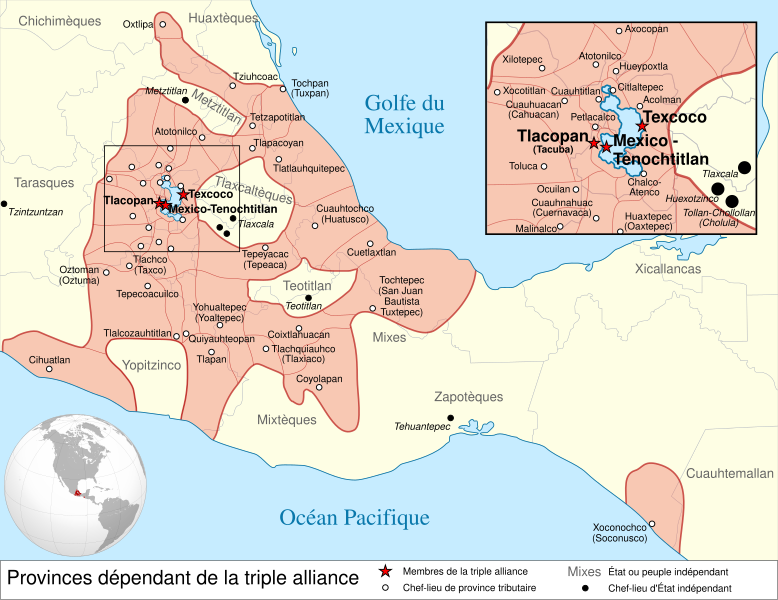
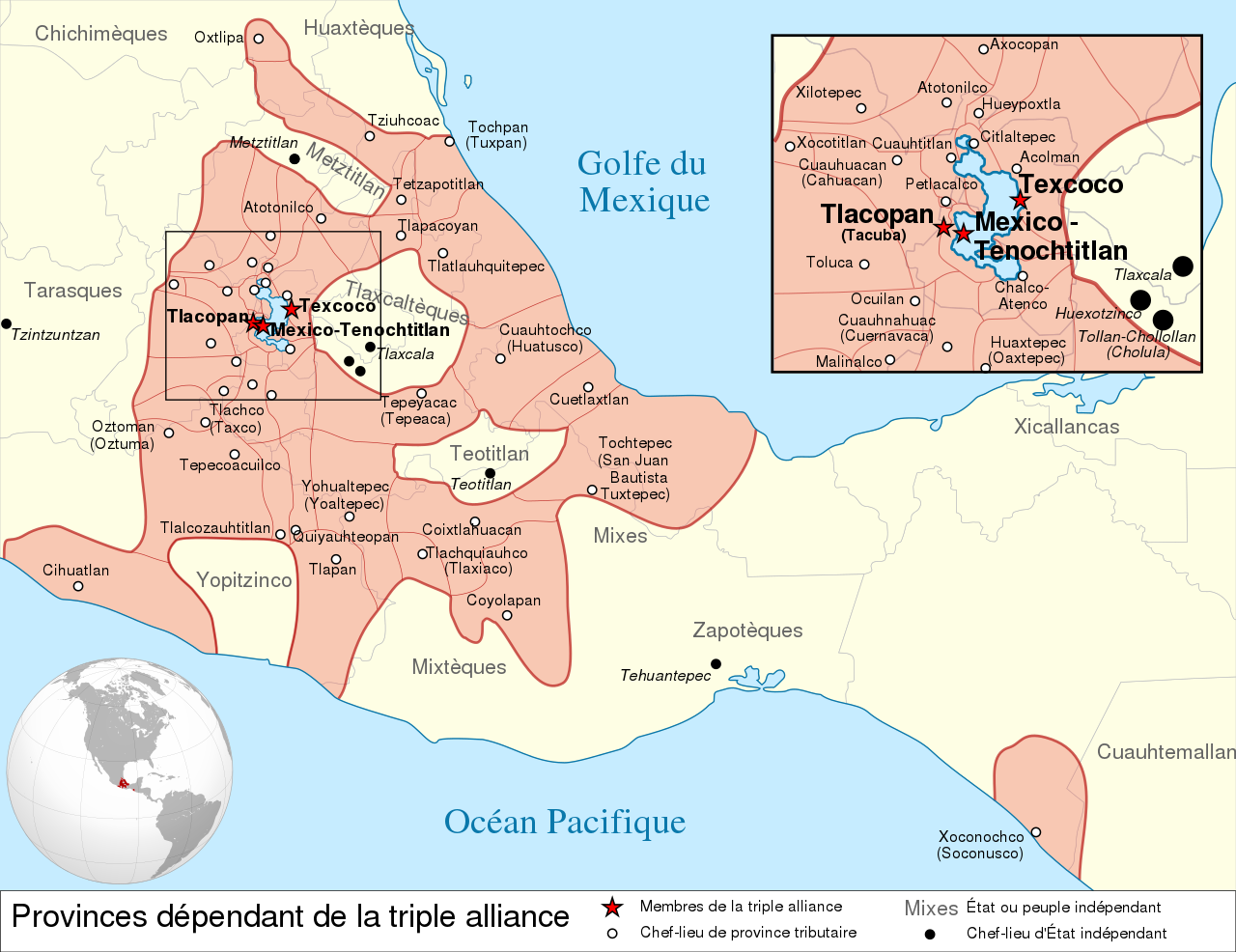
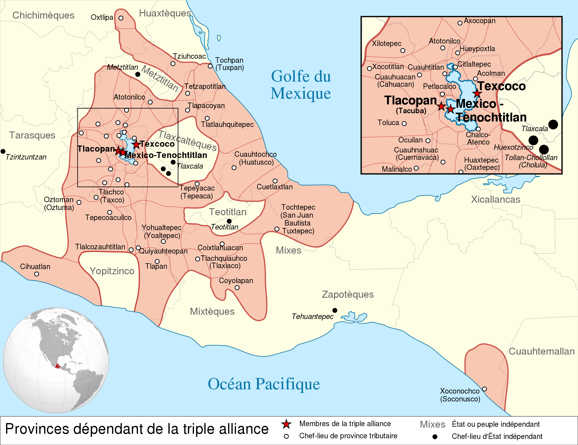
Español: Provincias tributarias de la Triple Alianza encabezada por Tenochtitlan antes de la llegada de los españoles en 1519.
English: Map of the Aztec Empire lead by Tenochtitlan circa 1519, before the arrival of the Spanish.
Français : Étendue de l'empire Aztèque soumis à la Triple Alliance, dirigée par Tenochtitlan, à l'arrivée des Espagnols en 1519. |
| Deiziad | (UTC) |
| Mammenn |
|
| Aozer | |
| Stummoù all |
[] Detailed maps
Simple maps
|


.svg)
.svg)
.svg)
| Lec’h luc’hskeudennerez | | Gwelet al lec’h-se e : OpenStreetMap |
|---|

|
This SVG file contains embedded text that can be translated into your language, using any capable SVG editor, text editor or the SVG Translate tool. For more information see: About translating SVG files. |
This W3C-unspecified vector image was created with Inkscape .
Aotre-implijout
Emañ ar restr-mañ dindan an aotre-implijout Creative Commons Deroadenn-Kenrannañ 3.0 Unported
- Gallout a rit :
- eskemm – eilañ, skignañ ha treuzkas an oberenn-mañ
- kemmañ – azasaat an oberenn-mañ
- diouzh ma heuilhit kement-mañ :
- deroadenn – Rankout a rit reiñ an titouroù perc'henniezh rekis diwar-benn an aozer, pourchas ul liamm war-zu an aotre-implijout ha merkañ hag-eñ ez eus bet graet kemmoù. Gallout a rit en ober en un doare reizh met hep lakaat da grediñ ez oc'h bet aprouet gantañ pe ez eo aprouet gantañ implij an oberenn-mañ.
- eskemmañ rik-ha-rik – Ma tegasit kemmoù, ma treuzfurmit pe ma savit un dra bennak diwar an oberenn-mañ e rankit skignañ an oberenn krouet ganeoc'h dindan an hevelep aotre-implijout pe un aotre-implijout kar-tost d'an hini orin.
Marilh orin ar pellgargadurioù
This image is a derivative work of the following images:
- File:Provincias_tributarias_de_la_Triple_Alianza_(s._XVI).svg licensed with Cc-by-sa-3.0-migrated, FAL, GFDL
- 2008-12-13T03:29:16Z Yavidaxiu 949x731 (878329 Bytes) {{Information |Description={{es|1=Provincias tributarias de la Triple Alianza encabezada por Tenochtitlan antes de la llegada de los españoles. Fuente: ''Atlas del México prehispánico'', edición especial de ''Arqueología
- File:Aztec_Empire_(orthographic_projection).svg licensed with Cc-by-sa-3.0, GFDL
- 2010-02-11T12:23:41Z Sémhur 550x550 (104628 Bytes) Update with data from a sourced map.
- 2010-01-10T20:34:52Z Keepscases 550x550 (284361 Bytes) {{Information |Description={{en|1=Aztec Empire (orthographic projection)}} |Source={{own}} |Author=[[User:Keepscases|Keepscases]] |Date= |Permission= |other_versions= }} [[Category:SVG - Orthographic projections]]
Uploaded with derivativeFX
Istor ar restr
Klikañ war un deiziad/eur da welet ar restr evel ma oa da neuze.
| Deiziad/Eur | Munud | Mentoù | Implijer | Notenn | |
|---|---|---|---|---|---|
| red | 23 Meu 2010 da 15:01 | | 1 898 × 1 462 (303 Kio) | El Comandante | État tarasque->Tarasques + Royaumes mixtèques->Mixtèques + Correction du positionnement de 2 textes |
| 7 Meu 2010 da 17:58 |  | 1 898 × 1 462 (303 Kio) | El Comandante | More readable fonts | |
| 25 C'hwe 2010 da 18:06 |  | 1 898 × 1 462 (306 Kio) | Sémhur | Font : Nimbus Sans L | |
| 24 C'hwe 2010 da 17:29 |  | 949 × 731 (305 Kio) | Sémhur | 2 - Encart de la région centrale | |
| 11 C'hwe 2010 da 12:55 |  | 949 × 731 (262 Kio) | Sémhur | == {{int:filedesc}} == {{Information |Description={{es|1=Provincias tributarias de la Triple Alianza encabezada por Tenochtitlan antes de la llegada de los españoles en 1519.}} {{en|1=Map of the [[:en:Aztec Empire[Aztec Empire]] lead by Tenochtitlan circ |
Implij ar restr
Implijout a ra an 19 pajenn da heul ar restr-mañ :
Implij hollek ar restr
Ober a ra ar wikioù da-heul gant ar restr-mañ :
- Implij war af.wikipedia.org
- Implij war ar.wikipedia.org
- Implij war azb.wikipedia.org
- Implij war el.wikipedia.org
- Implij war en.wikipedia.org
- Aztecs
- List of conflicts in North America
- Aztec Empire
- Wikipedia:WikiProject Aztec/Backup 2006-07-17
- Tlaxcala (Nahua state)
- Aztec architecture
- User:Maunus/sandbox
- Template:Aztec
- List of conflicts in Mexico
- User:Bobo.03/sandbox
- User:Tisquesusa/sandbox9
- Xihuitl Temoc
- User:SomeGuyWhoRandomlyEdits/List of conflicts in Mexico
- Talk:Aztec Empire/Archive 1
- Implij war en.wikibooks.org
- Implij war fi.wikipedia.org
- Implij war fr.wikipedia.org
- Implij war hy.wikipedia.org
- Implij war id.wikipedia.org
- Implij war id.wikibooks.org
- Implij war it.wikipedia.org
- Implij war ja.wikipedia.org
- Implij war la.wikipedia.org
- Implij war lfn.wikipedia.org
- Implij war li.wikipedia.org
- Implij war lv.wikipedia.org
- Implij war no.wikipedia.org
- Implij war nv.wikipedia.org
- Implij war pt.wikipedia.org
- Implij war ro.wikipedia.org
- Implij war ru.wikipedia.org
- Implij war simple.wikipedia.org
- Implij war sl.wikipedia.org
- Implij war ta.wikipedia.org
- Implij war uk.wikipedia.org
- Implij war vi.wikipedia.org