
Restr:Beauplan Poland XVII map.jpg
Restr orin (6 674 × 5 244 piksel, ment ar restr : 25,99 Mio, seurt MIME : image/jpeg)
![]()
| Tennet eo ar restr-mañ eus Wikimedia Commons ha gallout a ra bezañ implijet evit raktresoù all. Diskouezet eo deskrivadur he fajenn zeskrivañ amañ dindan. |
Diverradur
| Deskrivadur |
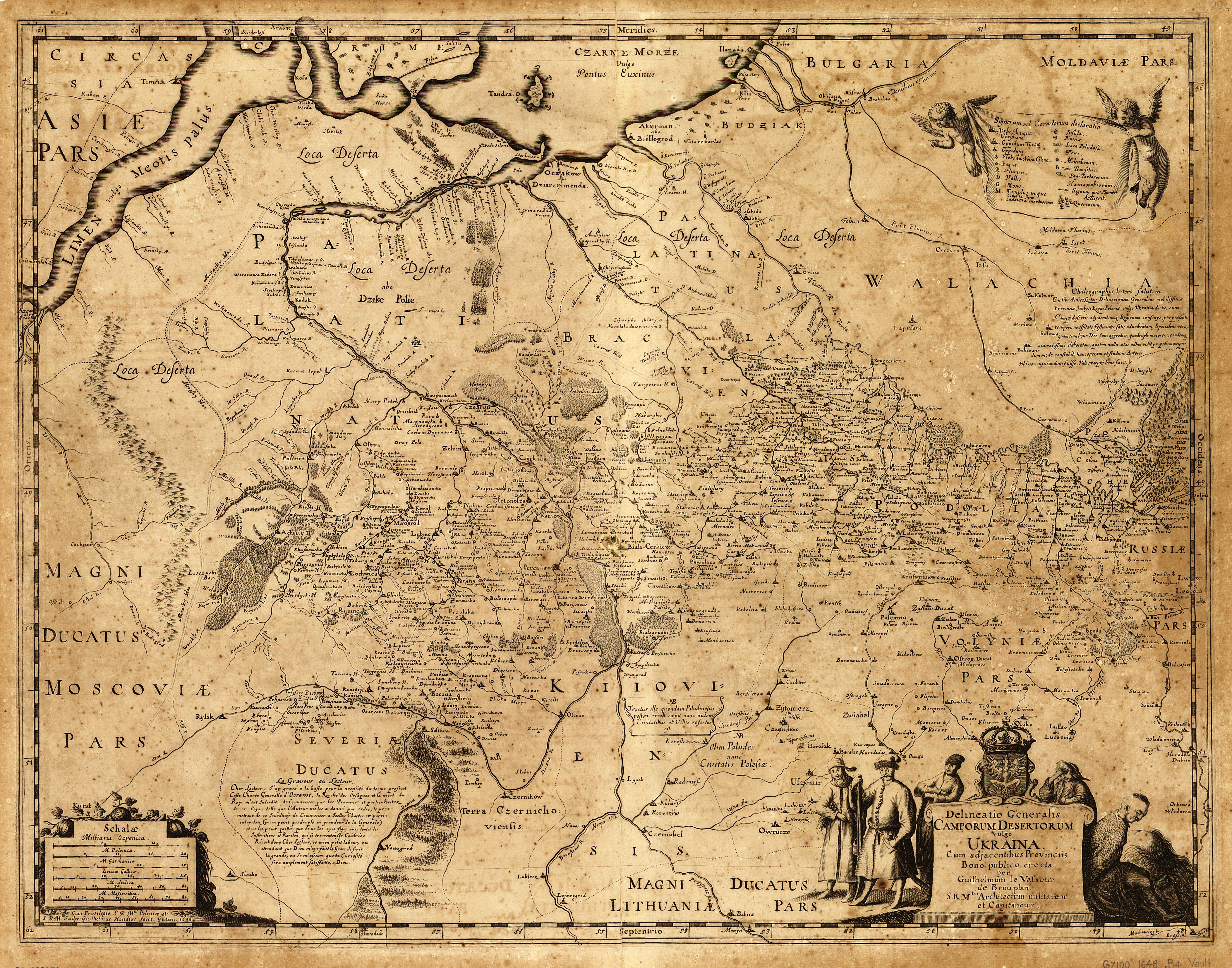
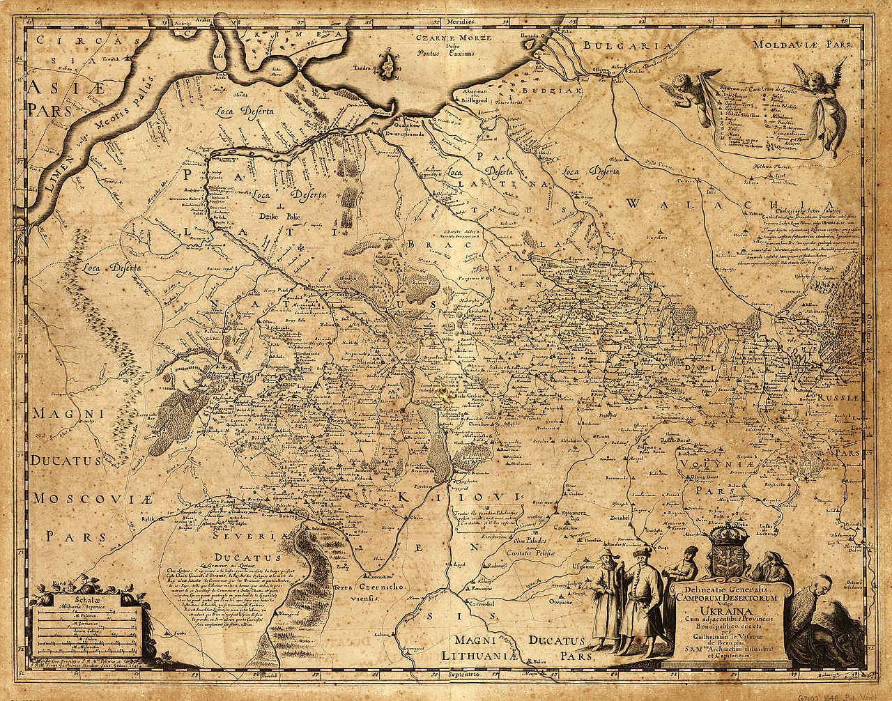
English: «Delineatio Generalis Camporum Desertorum vulgo Ukraina. Cum adjacentibus Provinciis».
Latina: Delineatio generalis Camporum Desertorum vulgo Ukraina: cum adjacentibus provinciis / bono publico erecta per Guilhelmum le Vasseur de Beauplan, S. R. M'tis architectum militarem et capitaneum ; sculpt. Guilhelmus Hondius fecit, Gedani, 1648.
Polski: Mapa Dzikich Pól inaczej Ukrainy, z przyległymi prowincjami. Sporządzona dla dobra publicznego przez Wilhelma de Beauplana w 1648 w Gdańsku na polecenie Władysława IV, Króla Polski
|
| Deiziad | |
| Mammenn | Description de l'Ukrainie, qui sont plusieurs provinces du Royaume de Pologne, Contenuës depuis les confins de la Moscovie, jusques aux limites de la Transilvanie. Ensemble leurs moeurs, façcons de vivres et de faire la Guerre. Par le Sieur de Beauplan |
| Aozer | Vasseur de Beauplan |
NOTES Scale ca. 1:1,750,000.
Relief shown pictorially.
Oriented with north to the bottom.
Includes text in Latin and French and ill.
SUBJECTS Ukraine--Maps--Early works to 1800. Ukraine.
RELATED NAMES Hondius, Willem.
MEDIUM 1 map ; 43 x 55 cm.
CALL NUMBER G7100 1648 .B4 Vault
REPOSITORY Library of Congress Geography and Map Division Washington, D.C. 20540-4650 USA http://memory.loc.gov/cgi-bin/query/h?ammem/gmd:@field%28NUMBER+@band%28g7100+ct000383%29%29
Aotre-implijout
|
This work is in the public domain in its country of origin and other countries and areas where the copyright term is the author's life plus 100 years or fewer. This work is in the public domain in the United States because it was published (or registered with the U.S. Copyright Office) before January 1, 1929. | |
| Rummet eo bet ar restr-mañ e-touez ar restroù hep strishadurioù implij anavezet evit ar pezh a sell ouzh ar gwirioù aozer, ha kement-se evit an holl wirioù kar ha stag. | |
Istor ar restr
Klikañ war un deiziad/eur da welet ar restr evel ma oa da neuze.
| Deiziad/Eur | Munud | Mentoù | Implijer | Notenn | |
|---|---|---|---|---|---|
| red | 15 Mez 2014 da 12:10 | | 6 674 × 5 244 (25,99 Mio) | Gerodian | Карта с большим разрешением и в лучшем качестве |
| 13 Her 2013 da 13:51 |  | 3 000 × 2 357 (2,52 Mio) | Andros64 | better quality | |
| 24 Gen 2011 da 10:02 |  | 3 000 × 2 357 (1,95 Mio) | Bornholm | {{Information |Description ={{en|1=The map Kingdom of Poland (es. "Wild Fields") near the Black Sea from 17 c. made on order King of Poland Władysław IV Vasa by Guillaume le Vasseur de Beauplan. Original latin name: Delineatio generalis Camporum Dese |
Implij ar restr
Implijout a ra ar bajenn da heul ar restr-mañ :
Implij hollek ar restr
Ober a ra ar wikioù da-heul gant ar restr-mañ :
- Implij war ar.wikipedia.org
- Implij war az.wikipedia.org
- Implij war be-tarask.wikipedia.org
- Implij war ca.wikipedia.org
- Implij war ce.wikipedia.org
- Implij war cs.wikipedia.org
- Implij war de.wikipedia.org
- Implij war en.wikipedia.org
- Implij war es.wikipedia.org
- Implij war et.wikipedia.org
- Implij war fr.wikipedia.org
- Implij war it.wikipedia.org
- Implij war la.wikipedia.org
- Implij war lt.wikipedia.org
- Implij war nl.wikipedia.org
- Implij war pl.wikipedia.org
- Implij war ro.wikipedia.org
- Implij war ru.wikipedia.org
Gwelet muioc'h eus implij hollek ar restr-mañ.