
Restr:Situationsplan von Cadiz.jpg
Ment ar rakweled-mañ : 495 × 600 piksel. pizhderioù all : 198 × 240 piksel | 500 × 606 piksel.
Restr orin (500 × 606 piksel, ment ar restr : 97 Kio, seurt MIME : image/jpeg)
![]()
| Tennet eo ar restr-mañ eus Wikimedia Commons ha gallout a ra bezañ implijet evit raktresoù all. Diskouezet eo deskrivadur he fajenn zeskrivañ amañ dindan. |
Diverradur
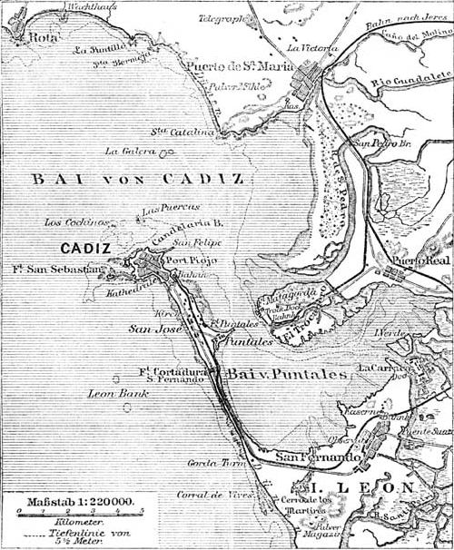
Español: Mapa histórico de la bahía
Quelle: Meyers Konversationslexikon von 1888, Band 3, Seite 718
| This image comes from the 4th edition of Meyers Konversationslexikon (1885–90). The copyrights have expired and this image is in the public domain. |
|
This work is in the public domain in its country of origin and other countries and areas where the copyright term is the author's life plus 100 years or fewer. This work is in the public domain in the United States because it was published (or registered with the U.S. Copyright Office) before January 1, 1929. | |
| Rummet eo bet ar restr-mañ e-touez ar restroù hep strishadurioù implij anavezet evit ar pezh a sell ouzh ar gwirioù aozer, ha kement-se evit an holl wirioù kar ha stag. | |
Istor ar restr
Klikañ war un deiziad/eur da welet ar restr evel ma oa da neuze.
| Deiziad/Eur | Munud | Mentoù | Implijer | Notenn | |
|---|---|---|---|---|---|
| red | 15 Gen 2005 da 18:32 | | 500 × 606 (97 Kio) | ¡0-8-15! | {{PD-Meyers}} |
Implij ar restr
Implijout a ra ar bajenn da heul ar restr-mañ :
Implij hollek ar restr
Ober a ra ar wikioù da-heul gant ar restr-mañ :
- Implij war ca.wikipedia.org
- Implij war ceb.wikipedia.org
- Implij war de.wikipedia.org
- Implij war en.wikipedia.org
- Implij war es.wikipedia.org
- Implij war eu.wikipedia.org
- Implij war fa.wikipedia.org
- Implij war fr.wikipedia.org
- Implij war it.wikipedia.org
- Implij war ja.wikipedia.org
- Implij war ko.wikipedia.org
- Implij war nl.wikipedia.org
- Implij war nn.wikipedia.org
- Implij war pt.wikipedia.org
- Implij war ru.wikipedia.org
- Implij war sv.wikipedia.org
- Implij war uk.wikipedia.org
- Implij war www.wikidata.org
- Implij war zh.wikipedia.org