
Restr:Pano-fl.jpg

Ment ar rakweled-mañ : 800 × 198 piksel. pizhderioù all : 320 × 79 piksel | 640 × 158 piksel | 1 024 × 253 piksel | 1 280 × 317 piksel | 2 560 × 633 piksel | 9 409 × 2 327 piksel.
Restr orin (9 409 × 2 327 piksel, ment ar restr : 17,45 Mio, seurt MIME : image/jpeg)
![]()
| Tennet eo ar restr-mañ eus Wikimedia Commons ha gallout a ra bezañ implijet evit raktresoù all. Diskouezet eo deskrivadur he fajenn zeskrivañ amañ dindan. |
Diverradur
| Deskrivadur |
|
||||||||||||||||||||||
| Deiziad | |||||||||||||||||||||||
| Mammenn |
|
||||||||||||||||||||||
| Aozer |
Thomas Bresson from Belfort, France
|
||||||||||||||||||||||


| Lec’h luc’hskeudennerez | | Gwelet al lec’h-se e : OpenStreetMap |
|---|
Aotre-implijout
Emañ ar restr-mañ dindan an aotre-implijout Creative Commons Deroadenn 2.0 Hollek
- Gallout a rit :
- eskemm – eilañ, skignañ ha treuzkas an oberenn-mañ
- kemmañ – azasaat an oberenn-mañ
- diouzh ma heuilhit kement-mañ :
- deroadenn – Rankout a rit reiñ an titouroù perc'henniezh rekis diwar-benn an aozer, pourchas ul liamm war-zu an aotre-implijout ha merkañ hag-eñ ez eus bet graet kemmoù. Gallout a rit en ober en un doare reizh met hep lakaat da grediñ ez oc'h bet aprouet gantañ pe ez eo aprouet gantañ implij an oberenn-mañ.
| This image, originally posted to Flickr, was reviewed on January 20, 2010 by the administrator or reviewer File Upload Bot (Magnus Manske), who confirmed that it was available on Flickr under the stated license on that date. |
| Annotations | This image is annotated: View the annotations at Commons |
This image has been assessed using the Quality image guidelines and is considered a Quality image.
|
Istor ar restr
Klikañ war un deiziad/eur da welet ar restr evel ma oa da neuze.
| Deiziad/Eur | Munud | Mentoù | Implijer | Notenn | |
|---|---|---|---|---|---|
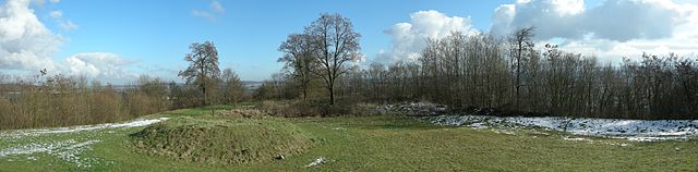
| red | 20 Gen 2010 da 12:17 | 9 409 × 2 327 (17,45 Mio) | File Upload Bot (Magnus Manske) | {{Information |Description=Panorama vu depuis la table d'orientation de l'enveloppe du Fort Lachaux. Lachaux fortifications. |Source=[http://www.flickr.com/photos/36519414@N00/4285061221/ Fort Lachaux] * Uploaded by [[User:ComputerHotline|ComputerHotline |
Implij ar restr
Implijout a ra ar bajenn da heul ar restr-mañ :
Implij hollek ar restr
Ober a ra ar wikioù da-heul gant ar restr-mañ :
- Implij war fr.wikipedia.org