
Restr:Italy 1000 AD-de.svg

Ment rakwel PNG ar restr SVG : 419 × 600 piksel. pizhderioù all : 167 × 240 piksel | 335 × 480 piksel | 536 × 768 piksel | 715 × 1 024 piksel | 1 430 × 2 048 piksel | 572 × 819 piksel.
Restr orin (restr SVG file, pizhder 572 × 819 piksel, ment ar restr : 334 Kio)
![]()
| Tennet eo ar restr-mañ eus Wikimedia Commons ha gallout a ra bezañ implijet evit raktresoù all. Diskouezet eo deskrivadur he fajenn zeskrivañ amañ dindan. |
Diverradur
| Deskrivadur |
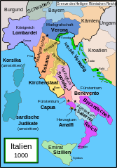
English: Political map of Italy in 1000 AD (CE). German translation of Image:Italy_1000_AD.svg which was created by MapMaster.
Part of a series of maps on the history of Italy:
|
| Deiziad | 20 Kerzu 2007 (original upload date) |
| Mammenn | La source n’a pas pu être reconnue automatiquement. « Travail personnel » supposé (étant donné la revendication de droit d’auteur). |
| Aozer | L’auteur n’a pas pu être identifié automatiquement. Il est supposé qu'il s'agit de : Bamse (étant donné la revendication de droit d’auteur). |
| Stummoù all |
[]
SVG:
PNG:
|


|
This SVG file contains embedded text that can be translated into your language, using any capable SVG editor, text editor or the SVG Translate tool. For more information see: About translating SVG files. |
References
- Bjorklund, Oddvar; Holmboe, Haakon; Rohr, Anders (1970) Historical Atlas of the World, Barnes & Noble, NY, SBN: 389-00253-4.
- This map from Allyn & Bacon, Longman, textbook publishers.
- This map of the w:en:Holy Roman Empire
- A map from Attilios
- This map of 1050 AD Italy, from the 1923 The Historical Atlas by William R. Shepherd
- This map of 1000 AD Italy from Fordham University, adapted from Muir's Historical Atlas, (1911).
In addition, a number of other sources were consulted in an effort to determine the following matters:
- The extent of Venetian control over the cities of Dalmatia such as Zara and Spalato. Although the Venetians had been pushed off the mainland earlier, in the period around the year 1000, the Venetians made an effort to recover these cities.
- The extent of Saracen control over Corsica and Sardinia. Information is sparse. The apparent situation is that the Muslims had several bases on the coasts of these islands, but did not control the countryside (such as they did in Sicily).
- Whether or not the principalities of Capua and Benevento were separate states in the year 1000. Based on lists of their rulers (various Pandulfs and Landulfs), the answer seems to be "yes".
- Who controlled the Balkans on the southeastern border of the Kingdom of Croatia. Candidates include Bulgaria, the Byzantine Empire, Croatia, and Serbia.
As noted, there is significant disagreement among sources on these questions.
This map was commissioned by Attilios, and there is also a discussion to be found on MapMaster's English talk page.
Aotre-implijout
Evel perc'henn eus ar gwirioù oberour, e embannan an oberenn-mañ dindan an aotre-implijout da-heul :

|
Aotre zo da eilañ, skignañ ha kemmañ an teul-mañ dindan termennoù ar GNU Free Documentation License, stumm 1.2 pe stummoù nevesoc'h embannet gant ar Free Software Foundation; hep rannoù digemm, na testenn pajenn golo 1 pe golo 4 ebet. Kavet e vo un eilskrid eus an aotre-implijout er rannbennad anvet GNU Free Documentation License. |
| Emañ ar restr-mañ dindan an aotre-implijout Creative Commons Deroadenn-Kenrannañ 3.0 Unported | ||
| ||
| Ouzhpennet eo bet an dikedenn aotre-implijout-mañ d'ar restr-mañ evel darn eus hizivadur aotreoù-implijout ar GFDL. |
Istor ar restr
Klikañ war un deiziad/eur da welet ar restr evel ma oa da neuze.
| Deiziad/Eur | Munud | Mentoù | Implijer | Notenn | |
|---|---|---|---|---|---|
| red | 11 Ebr 2009 da 16:36 | | 572 × 819 (334 Kio) | Rhegion | aggiunta Reggio |
| 20 Kzu 2007 da 08:05 |  | 572 × 819 (332 Kio) | Bamse | == Summary == '''de:''' Political map of Italy in 1000 AD (CE). German translation of Image:Italy_1000_AD.svg which was created by MapMaster. Part of a series of maps on the history of Italy: <gallery> Image:Italy and Illyria 1084 v2.svg|1084 AD Im |
Implij ar restr
Pajenn ebet ne implij ar restr-mañ.
Implij hollek ar restr
Ober a ra ar wikioù da-heul gant ar restr-mañ :
- Implij war da.wikipedia.org
- Implij war de.wikipedia.org
- 1011
- 1016
- 1018
- 1000
- Korsika
- Mark (Territorium)
- Etrurien
- Pietro II. Orseolo
- Herzogtum Benevent
- Herzogtum Spoleto
- Pietro II. Candiano
- Markgrafschaft Verona
- Pietro Orseolo
- Fürstentum Capua
- Pietro Badoer
- Vitale Candiano
- Tribuno Memmo
- Wikipedia:Kartenwerkstatt/Archiv/2007-12
- Herzogtum Amalfi
- Normannische Eroberung Süditaliens
- Katepanat Italien
- Abu l-Qasim (Emir)
- Hassan al-Kalbi
- Ottone Orseolo
- Pietro III. Candiano
- Pietro IV. Candiano
- Civita
- Nikephoros Phokas der Ältere
- Pandulf I.
- Italien-Runensteine
- Benutzer:Methodios/Boioannes
- Giovanni Orseolo
- Emirat von Sizilien
- Markgrafschaft Tuscien
- Waldrada (ductrix)
- Cesina
- Liste der historischen Staaten in Italien
- Maria (ductrix)
- Johanna (ductrix)
- Italienische Münzgeschichte
- Implij war de.wikibooks.org
- Implij war de.wikiversity.org
- Implij war eo.wikipedia.org
- Implij war nl.wikipedia.org
- Implij war uk.wikipedia.org