
Restr:Carte de France 1789 Bretagne.jpg
Carte_de_France_1789_Bretagne.jpg (300 × 299 piksel, ment ar restr : 88 Kio, seurt MIME : image/jpeg)
![]()
| Tennet eo ar restr-mañ eus Wikimedia Commons ha gallout a ra bezañ implijet evit raktresoù all. Diskouezet eo deskrivadur he fajenn zeskrivañ amañ dindan. |
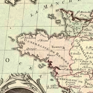
| Deskrivadur | Partie bretonne de la carte intitulée "La France divisée en ses généralités ou intendances et pays d'Etats avec les chefs-lieux des élections, bailliages, territoires, prévôtés, subdélégations etc. Pour être insérée dans la lettre du roi pour la convocation des Etats généraux, du 24 janvier 1789." Gravure rehaussée de couleurs. Hors carte, à droite, liste des villes administratives des zones frontières du Nord et de l'Est, et à gauche, portrait anonyme du ministre Necker en médaillon, souligné de quatre vers de P.-L. Moline. "A Paris, chez Desnos, ingénieur géographe du roi, rue Saint-Jacques, au Globe" |
| Deiziad | (UTC) |
| Mammenn | |
| Aozer |
|
| This is a retouched picture, which means that it has been digitally altered from its original version. Modifications: Cropped to focus on Brittany, slightly enhanced colours.. The original can be viewed here: Carte de France 1789.jpg:
|
|
This work is in the public domain in its country of origin and other countries and areas where the copyright term is the author's life plus 70 years or fewer.
| |
| Rummet eo bet ar restr-mañ e-touez ar restroù hep strishadurioù implij anavezet evit ar pezh a sell ouzh ar gwirioù aozer, ha kement-se evit an holl wirioù kar ha stag. | |
Marilh orin ar pellgargadurioù
This image is a derivative work of the following images:
- Image:Carte_de_France_1789.jpg licensed with PD-old
- 2005-06-27T22:21:38Z Yann 1789x1240 (281673 Bytes) Carte intitulée "La France divisée en ses généralités ou intendances et pays d'Etats avec les chefs-lieux des élections, bailliages, territoires, prévôtés, subdélégations etc. Pour être insérée dans la lettre du
Uploaded with derivativeFX
Istor ar restr
Klikañ war un deiziad/eur da welet ar restr evel ma oa da neuze.
| Deiziad/Eur | Munud | Mentoù | Implijer | Notenn | |
|---|---|---|---|---|---|
| red | 16 Gou 2008 da 17:09 | | 300 × 299 (88 Kio) | QuartierLatin1968 | {{Information |Description=Partie bretonne de la carte intitulée "La France divisée en ses généralités ou intendances et pays d'Etats avec les chefs-lieux des élections, bailliages, territoires, prévôtés, subdélégations etc. Pour être inséré |
Implij ar restr
Implijout a ra ar bajenn da heul ar restr-mañ :
Implij hollek ar restr
Ober a ra ar wikioù da-heul gant ar restr-mañ :
- Implij war eu.wikipedia.org
- Implij war fi.wikipedia.org
- Implij war fr.wikipedia.org
- Implij war ja.wikipedia.org
- Implij war kw.wikipedia.org