
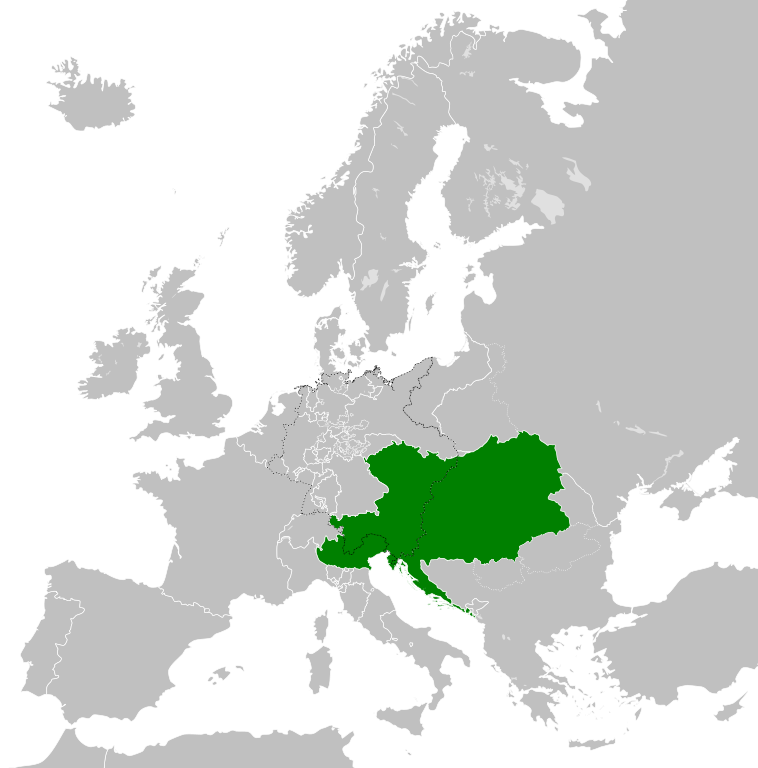
Restr:Austrian Empire (1815).svg

Ment rakwel PNG ar restr SVG : 450 × 456 piksel. pizhderioù all : 237 × 240 piksel | 474 × 480 piksel | 758 × 768 piksel | 1 011 × 1 024 piksel | 2 021 × 2 048 piksel.
Restr orin (restr SVG file, pizhder 450 × 456 piksel, ment ar restr : 691 Kio)
![]()
| Tennet eo ar restr-mañ eus Wikimedia Commons ha gallout a ra bezañ implijet evit raktresoù all. Diskouezet eo deskrivadur he fajenn zeskrivañ amañ dindan. |
Diverradur


.svg)
.svg)
.svg)
.svg)
.svg)


.svg)
.svg)
.svg)


.png)
.png)


.svg)


.svg)

.svg)


.svg)
.svg)
.svg)
.svg)


.svg)
.png)


.svg)


.svg)
.svg)


.svg)


.svg)


.svg)
.svg)
.svg)
.svg)
.svg)
.svg)
.svg)
.svg)
_cropped.svg)
.svg)
.svg)
.svg)
.svg)
.svg)
.svg)
.svg)
.svg)
.svg)
.svg)
.svg)
.svg)
.svg)
.svg)
.svg)
.svg)
.svg)
.svg)
.svg)
.svg)
.svg)
.svg)
.svg)
.svg)
.svg)
.svg)
.svg)
.svg)
.svg)
.svg)
.svg)
.svg)
.svg)
.svg)
.svg)
.svg)
.svg)
.svg)
.svg)
.svg)
.svg)
.svg)
.svg)
.svg)
.svg)
Istor ar restr
Klikañ war un deiziad/eur da welet ar restr evel ma oa da neuze.
| Deiziad/Eur | Munud | Mentoù | Implijer | Notenn | |
|---|---|---|---|---|---|
| red | 16 Ebr 2019 da 09:58 | | 450 × 456 (691 Kio) | TRAJAN 117 | +++ |
| 12 Eos 2013 da 21:20 |  | 450 × 456 (654 Kio) | TRAJAN 117 | Update | |
| 12 Eos 2013 da 05:47 |  | 450 × 456 (1 Mio) | TRAJAN 117 | {{Information |Description ={{en|1=The Austrian Empire in 1815.}} |Source ={{own}} {{AttribSVG|Blank map of Europe 1815.svg|Alphathon}} |Author =TRAJAN 117 {{created with Inkscape}} |Date =2013-08-12 |Pe... |
Implij ar restr
Implijout a ra ar bajenn da heul ar restr-mañ :
Implij hollek ar restr
Ober a ra ar wikioù da-heul gant ar restr-mañ :
- Implij war af.wikipedia.org
- Implij war ast.wikipedia.org
- Implij war azb.wikipedia.org
- Implij war ba.wikipedia.org
- Implij war bg.wikipedia.org
- Implij war ce.wikipedia.org
- Implij war cs.wikipedia.org
- Implij war cy.wikipedia.org
- Implij war de.wikipedia.org
- Implij war el.wikipedia.org
- Implij war en.wikipedia.org
- Implij war es.wikipedia.org
- Implij war fi.wikipedia.org
- Implij war frr.wikipedia.org
- Implij war fr.wikipedia.org
- Implij war ga.wikipedia.org
- Implij war gd.wikipedia.org
- Implij war gl.wikipedia.org
- Implij war he.wikipedia.org
- Implij war hi.wikipedia.org
- Implij war hr.wikipedia.org
- Implij war hy.wikipedia.org
- Implij war id.wikipedia.org
- Implij war id.wikibooks.org
- Implij war incubator.wikimedia.org
- Implij war is.wikipedia.org
- Implij war it.wikipedia.org
- Implij war jam.wikipedia.org
- Implij war ja.wikipedia.org
- Implij war ka.wikipedia.org
- Implij war km.wikipedia.org
- Implij war ko.wikipedia.org
- Implij war ky.wikipedia.org
- Implij war lmo.wikipedia.org
- Implij war lt.wikipedia.org
- Implij war lv.wikipedia.org
- Implij war mk.wikipedia.org
- Implij war mn.wikipedia.org
- Implij war nap.wikipedia.org
- Implij war nl.wikipedia.org
- Implij war pa.wikipedia.org
Gwelet muioc'h eus implij hollek ar restr-mañ.
.svg)
.svg)