
Restr:Waldseemuller map 2.jpg

Restr orin (13 708 × 7 590 piksel, ment ar restr : 19,65 Mio, seurt MIME : image/jpeg)
![]()
| Tennet eo ar restr-mañ eus Wikimedia Commons ha gallout a ra bezañ implijet evit raktresoù all. Diskouezet eo deskrivadur he fajenn zeskrivañ amañ dindan. |
Diverradur
| Warning | The original file is very high-resolution. It might not load properly or could cause your browser to freeze when opened at full size. |
|---|
| Deskrivadur |
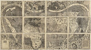
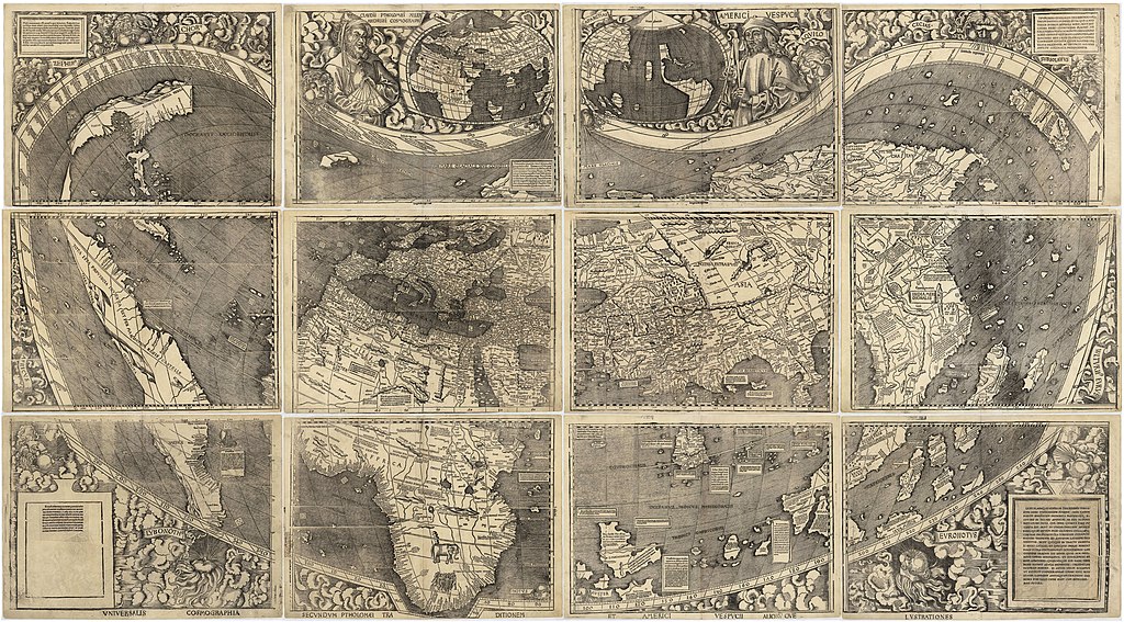
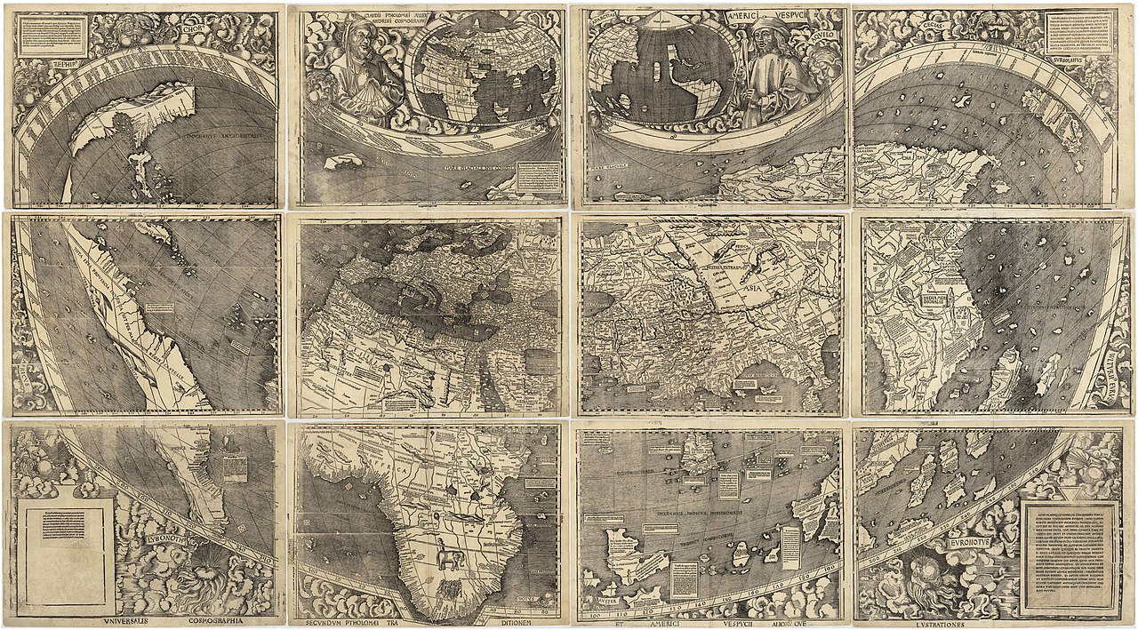
العربية: خريطة ڤالدسيمولير العائدة لِسنة 1507م. هذه الخريطة هي الأولى التي أوردت اسم «أمريكا» وأوَّل خريطة فصلت الأمريكتين عن آسيا. هذه النسخة هي الوحيدة الباقية، وقد اشترتها مكتبة الكونغرس سنة 2001م مُقابل 10 ملايين دولار أمريكي.
English: Waldseemüller map from 1507 is the first map to include the name "America" and the first to depict the Americas as separate from Asia. There is only one surviving copy of the map, which was purchased by the Library of Congress in 2001 for $10 million.
Français : Le planisphère de Waldseemüller de 1507 est la première carte mentionnant le nom "America" et la première à décrire les Amériques séparées de l'Asie. Il ne reste plus qu'une seule copie du planisphère encore existante à ce jour, acquise par la bibliothèque du Congrès en 2001 pour la somme de 10 millions de dollars. |
|||||||||||||||||||||||
| Deiziad | ||||||||||||||||||||||||
| Mammenn | https://www.loc.gov/resource/g3200.ct000725 | |||||||||||||||||||||||
| Aozer |
|
|||||||||||||||||||||||
| Stummoù all |
|
|||||||||||||||||||||||


Assessment
|

Aotre-implijout
|
This work is in the public domain in its country of origin and other countries and areas where the copyright term is the author's life plus 100 years or fewer. This work is in the public domain in the United States because it was published (or registered with the U.S. Copyright Office) before January 1, 1929. | |
| Rummet eo bet ar restr-mañ e-touez ar restroù hep strishadurioù implij anavezet evit ar pezh a sell ouzh ar gwirioù aozer, ha kement-se evit an holl wirioù kar ha stag. | |
Istor ar restr
Klikañ war un deiziad/eur da welet ar restr evel ma oa da neuze.
| Deiziad/Eur | Munud | Mentoù | Implijer | Notenn | |
|---|---|---|---|---|---|
| red | 27 Her 2008 da 17:37 | | 13 708 × 7 590 (19,65 Mio) | Jackaranga | {{Information |Description={{en|1=waldseemuller map, full page from http://memory.loc.gov/cgi-bin/map_item.pl?data=/home/www/data/gmd/gmd3/g3200/g3200/ct000725.jp2&style=gmd&itemLink=r?ammem/gmd:@field(NUMBER+@band(g3200+ct000725))&title=Universalis%20cos |
Implij ar restr
Implijout a ra ar bajenn da heul ar restr-mañ :
Implij hollek ar restr
Ober a ra ar wikioù da-heul gant ar restr-mañ :
- Implij war af.wikipedia.org
- Implij war als.wikipedia.org
- Implij war ar.wikipedia.org
- الأمريكتان
- العصر الحديث
- خريطة فالدسيمولير
- استكشاف أمريكا الشمالية
- بوابة:جغرافيا/صورة مختارة/أرشيف
- ويكيبيديا:صور مختارة/رسومات وجداول وخرائط/خرائط
- ويكيبيديا:ترشيحات الصور المختارة/خريطة فالدسيمولير
- ويكيبيديا:صورة اليوم المختارة/مارس 2018
- قالب:صورة اليوم المختارة/2018-03-24
- بوابة:جغرافيا/صورة مختارة/13
- ويكيبيديا:صورة اليوم المختارة/سبتمبر 2022
- قالب:صورة اليوم المختارة/2022-09-03
- Implij war ast.wikipedia.org
- Implij war az.wikipedia.org
- Implij war bg.wikipedia.org
- Implij war bn.wikipedia.org
- Implij war ca.wikipedia.org
- Implij war cs.wikipedia.org
- Implij war cy.wikipedia.org
- Implij war da.wikipedia.org
- Implij war de.wikipedia.org
- 16. Jahrhundert
- Christoph Kolumbus
- Neuzeit
- Martin Waldseemüller
- Weltkarte
- Benutzer:Mondamo/karten
- Liste historischer Weltkarten
- UNESCO-Kultur- und -Naturerbe
- Benutzer:GiFontenelle/Entwurf/Q131454, bibliothek
- Benutzer:Muhali/Waldseemüller Karte
- Benutzer:Springen/Waldseemüller-Karte
- Benutzer:Cupkake4Yoshi/History of geography
- Cosmographiae Introductio
- Implij war el.wikipedia.org
- Implij war en.wikipedia.org
Gwelet muioc'h eus implij hollek ar restr-mañ.