
Restr:Polynesia.png
Ment ar rakweled-mañ : 600 × 600 piksel. pizhderioù all : 240 × 240 piksel | 480 × 480 piksel | 768 × 768 piksel | 1 024 × 1 024 piksel | 2 000 × 2 000 piksel.
Restr orin (2 000 × 2 000 piksel, ment ar restr : 605 Kio, seurt MIME : image/png)
![]()
| Tennet eo ar restr-mañ eus Wikimedia Commons ha gallout a ra bezañ implijet evit raktresoù all. Diskouezet eo deskrivadur he fajenn zeskrivañ amañ dindan. |

|
This locator map image could be re-created using vector graphics as an SVG file. This has several advantages; see Commons:Media for cleanup for more information. If an SVG form of this image is available, please upload it and afterwards replace this template with
{{vector version available|new image name}}.
It is recommended to name the SVG file “Polynesia.svg”—then the template Vector version available (or Vva) does not need the new image name parameter. |
| Deskrivadur |
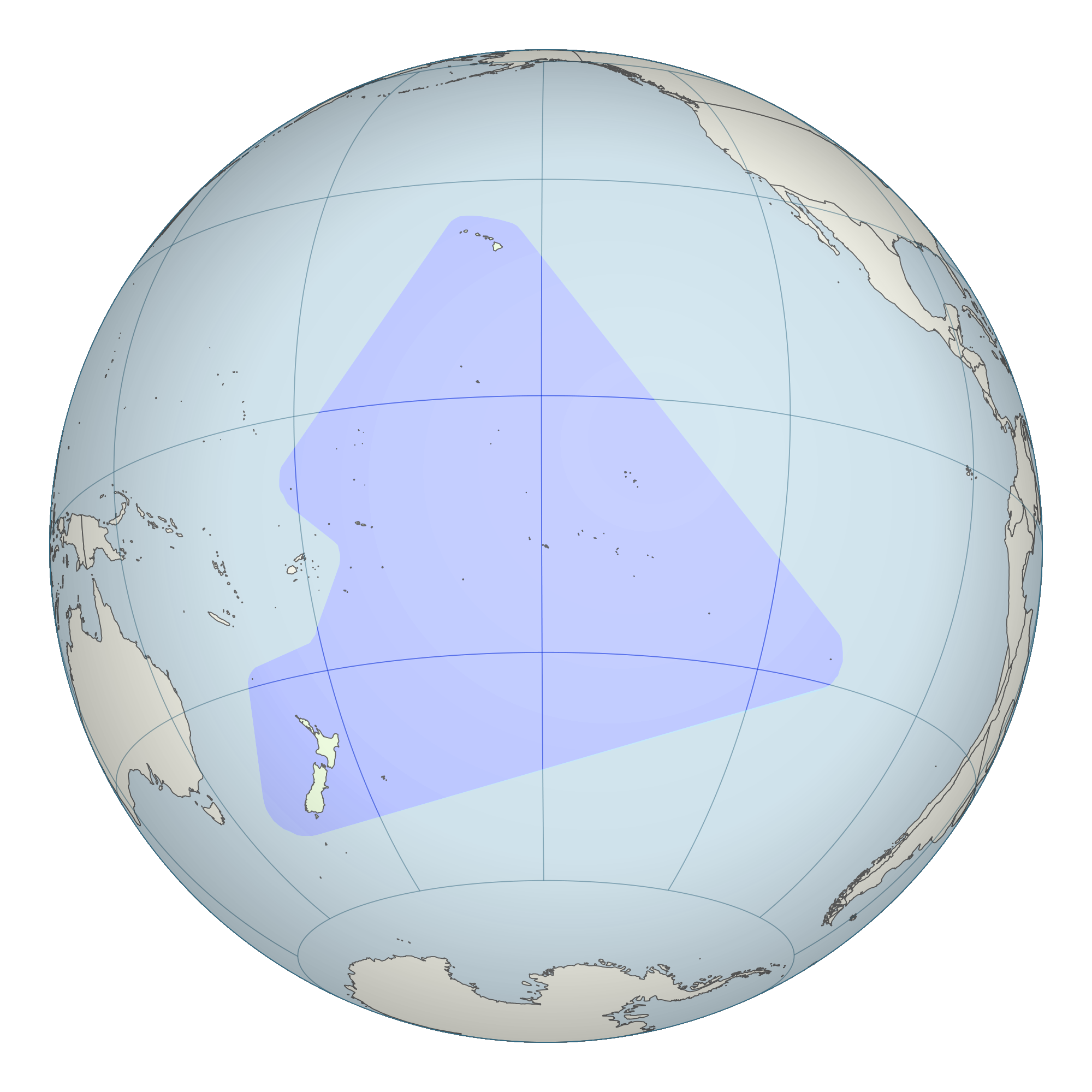
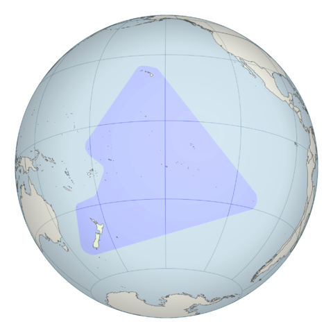
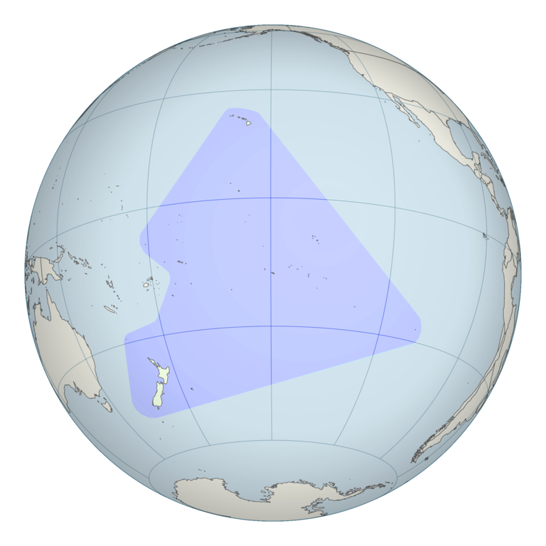
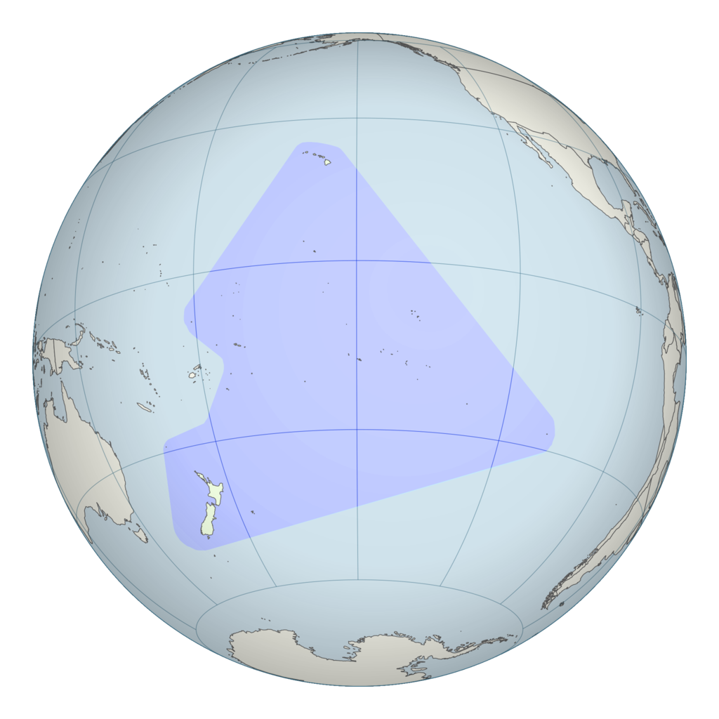
English: Polynesian triangle stretching from New Zealand in the south to Easter Island in the east and Hawaii in the north. This is a modification of File:French Polynesia (orthographic projection, yellowblue).svg. |
||
| Deiziad | ( | ||
| Mammenn | See File:French Polynesia (orthographic projection, yellowblue).svg; Map information based on Vaka Moana: Voyages of the Ancestors - the discovery and settlement of the Pacific, ed K.R. Howe, 2008, p57. | ||
| Aozer | User:Kahuroa | ||
| Aotre (Adimplij ar restr-mañ) |
|
.svg)
| Annotations | This image is annotated: View the annotations at Commons |
Istor ar restr
Klikañ war un deiziad/eur da welet ar restr evel ma oa da neuze.
| Deiziad/Eur | Munud | Mentoù | Implijer | Notenn | |
|---|---|---|---|---|---|
| red | 26 Her 2010 da 20:43 | | 2 000 × 2 000 (605 Kio) | Kahuroa | include Norfolk Island |
| 26 Her 2010 da 05:15 |  | 2 000 × 2 000 (615 Kio) | Kahuroa | more colour for background | |
| 26 Her 2010 da 04:15 |  | 2 000 × 2 000 (573 Kio) | Kahuroa | new version - corrects gross geographic errors of previous one. | |
| 23 Eos 2007 da 08:43 |  | 386 × 298 (4 Kio) | Quizimodo~commonswiki | updated; removing NZ (c.f. Australasia) | |
| 3 Ebr 2007 da 13:32 |  | 386 × 298 (36 Kio) | TadejM | {{Information |Description=This is a simple modification of en:Image:BlankMap-World.png. |Source=Originally from [http://en.wikipedia.org en.wikipedia]; description page is/was [http://en.wikipedia.org/w/index.php?title=Image%3APolynesia.png here]. | |
Implij ar restr
Pajenn ebet ne implij ar restr-mañ.
Implij hollek ar restr
Ober a ra ar wikioù da-heul gant ar restr-mañ :
- Implij war ar.wikipedia.org
- Implij war bpy.wikipedia.org
- মার্শাল দ্বীপমালার চিনত্হান
- ওশেনিয়ার চিনত্হান
- নাউরুর চিনত্হান
- নিউজিল্যান্ডর চিনত্হান
- পালাউর চিনত্হান
- পাপুয়া নিউগিনির চিনত্হান
- সামোয়ার চিনত্হান
- সলোমন দ্বীপমালার চিনত্হান
- টঙ্গার চিনত্হান
- টুভালুর চিনত্হান
- ভানুয়াতুর চিনত্হান
- ফিজির চিনত্হান
- কিরিবাতির চিনত্হান
- অস্ট্রেলিয়ার চিনত্হান
- মাইক্রোনেশিয়া তিলপারাষ্ট্রর চিনত্হান
- মডেল:ওশেনিয়ার বারে
- অস্ট্রেলিয়ার ফিরালহান
- ফিজির ফিরালহান
- কিরিবাতির ফিরালহান
- মার্শাল দ্বীপমালার ফিরালহান
- মাইক্রোনেশিয়া তিলপারাষ্ট্রর ফিরালহান
- নাউরুর ফিরালহান
- নিউজিল্যান্ডর ফিরালহান
- পালাউর ফিরালহান
- পাপুয়া নিউগিনির ফিরালহান
- সামোয়ার ফিরালহান
- সলোমন দ্বীপমালার ফিরালহান
- টঙ্গার ফিরালহান
- টুভালুর ফিরালহান
- ভানুয়াতুর ফিরালহান
- অস্ট্রেলিয়া
- ফিজি
- কিরিবাতি
- মার্শাল দ্বীপমালা
- মাইক্রোনেশিয়া তিলপারাষ্ট্র
- নাউরু
- নিউজিল্যান্ড
- পালাউ
- পাপুয়া নিউগিনি
- সামোয়া
- সলোমন দ্বীপমালা
- টঙ্গা
- টুভালু
Gwelet muioc'h eus implij hollek ar restr-mañ.