
Restr:Old map of Vietnam.jpg

Restr orin (3 024 × 2 179 piksel, ment ar restr : 1,99 Mio, seurt MIME : image/jpeg)
![]()
| Tennet eo ar restr-mañ eus Wikimedia Commons ha gallout a ra bezañ implijet evit raktresoù all. Diskouezet eo deskrivadur he fajenn zeskrivañ amañ dindan. |
Diverradur
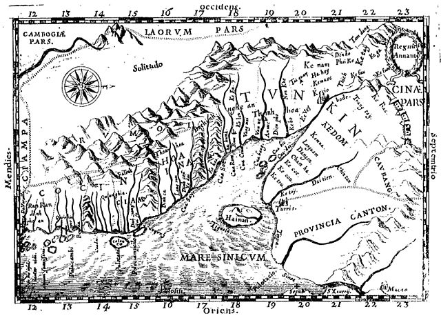
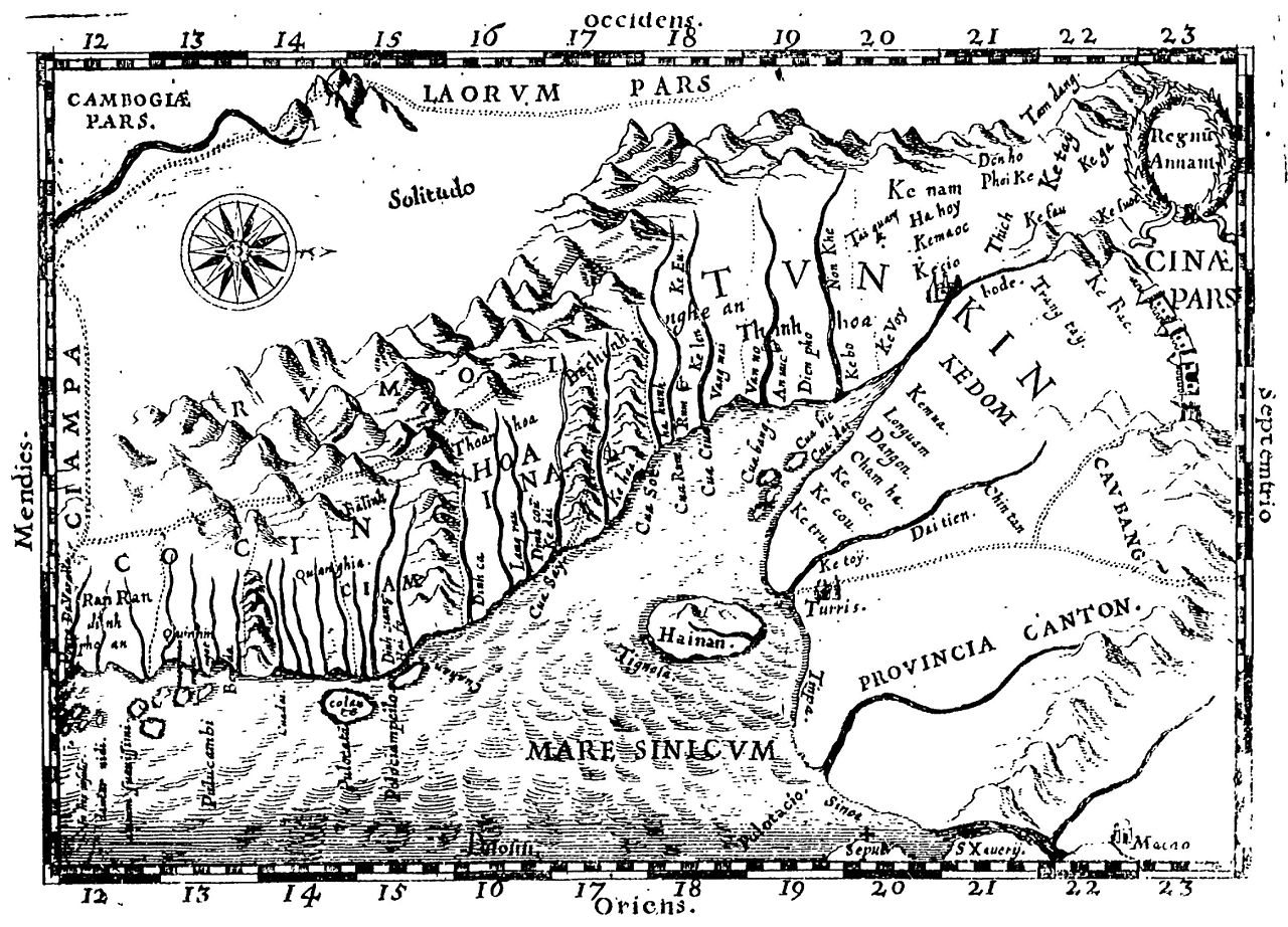
Early Western Map of Tonkin (1651). One of the earliest Western maps showing details of northern and central Vietnam appeared in Father Alexander de Rhodes's Histoire dv royavme de Tvnqvin, published in Rome in 1650. This map is from the French edition, published a year later in Lyon. Oriented with the north to the right, "Regnu Annam" shows the extent of seventeenth-century Vietnam, then divided between two rival dynasties, one in the north and the other in central Vietnam. Remnants of the Cham kingdom, eventually destroyed by the Vietnamese, still exist in the south. To the west, are the highlands occupied by "Rumoi" (upland minority groups, later called "montagnards" by the French). The limited Western knowledge of the interior is illustrated by the large region labeled "Solitudo."
(originally from https://www.loc.gov/rr/asian/guide/guide-southern.html) High-resolution version from The BNF
Aotre-implijout
|
This work is in the public domain in its country of origin and other countries and areas where the copyright term is the author's life plus 70 years or fewer.
| |
| Rummet eo bet ar restr-mañ e-touez ar restroù hep strishadurioù implij anavezet evit ar pezh a sell ouzh ar gwirioù aozer, ha kement-se evit an holl wirioù kar ha stag. | |
Istor ar restr
Klikañ war un deiziad/eur da welet ar restr evel ma oa da neuze.
| Deiziad/Eur | Munud | Mentoù | Implijer | Notenn | |
|---|---|---|---|---|---|
| red | 20 Ebr 2011 da 20:28 | | 3 024 × 2 179 (1,99 Mio) | Dragfyre | cropped to center the map image |
| 22 Mae 2009 da 11:52 |  | 3 298 × 2 581 (1,4 Mio) | DHN | updating high-res version | |
| 9 Gwe 2006 da 12:39 |  | 640 × 473 (105 Kio) | DHN | Early Western Map of Tonkin (1651). One of the earliest Western maps showing details of northern and central Vietnam appeared in Father Alexander de Rhodes's Histoire dv royavme de Tvnqvin, published in Rome in 1650. This map is from the French edition, |
Implij ar restr
Implijout a ra ar bajenn da heul ar restr-mañ :
Implij hollek ar restr
Ober a ra ar wikioù da-heul gant ar restr-mañ :
- Implij war ast.wikipedia.org
- Implij war azb.wikipedia.org
- Implij war az.wikipedia.org
- Implij war bn.wikipedia.org
- Implij war ca.wikipedia.org
- Implij war ceb.wikipedia.org
- Implij war da.wikipedia.org
- Implij war de.wikipedia.org
- Implij war en.wikipedia.org
- Implij war en.wiktionary.org
- Implij war eo.wikipedia.org
- Implij war es.wikipedia.org
- Implij war fr.wikipedia.org
- Implij war gl.wikipedia.org
- Implij war id.wikipedia.org
- Implij war it.wikipedia.org
- Implij war ja.wikipedia.org
- Implij war km.wikipedia.org
- Implij war ms.wikipedia.org
- Implij war no.wikipedia.org
- Implij war pl.wikipedia.org
- Implij war pt.wikipedia.org
- Implij war sl.wikipedia.org
- Implij war sv.wikipedia.org
- Implij war vi.wikipedia.org