
Restr:Map of Operation Eagle Pull evacuation sites.jpg
N'haller ket gwellaat ar pizhder.
Map_of_Operation_Eagle_Pull_evacuation_sites.jpg (600 × 552 piksel, ment ar restr : 95 Kio, seurt MIME : image/jpeg)
![]()
| Tennet eo ar restr-mañ eus Wikimedia Commons ha gallout a ra bezañ implijet evit raktresoù all. Diskouezet eo deskrivadur he fajenn zeskrivañ amañ dindan. |
Diverradur
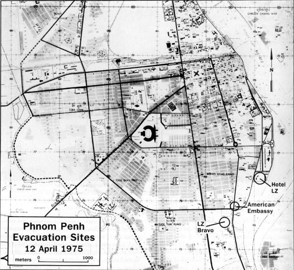
| Deskrivadur |
English: Map of possible helicopter landing zones for use in Operation Eagle Pull |
| Deiziad | |
| Mammenn | http://www.history.navy.mil/index.html |
| Aozer | US Navy |
Aotre-implijout
This file is a work of a sailor or employee of the U.S. Navy, taken or made as part of that person's official duties. As a work of the U.S. federal government, it is in the public domain in the United States.
|
 | |
| Rummet eo bet ar restr-mañ e-touez ar restroù hep strishadurioù implij anavezet evit ar pezh a sell ouzh ar gwirioù aozer, ha kement-se evit an holl wirioù kar ha stag. | ||
Istor ar restr
Klikañ war un deiziad/eur da welet ar restr evel ma oa da neuze.
| Deiziad/Eur | Munud | Mentoù | Implijer | Notenn | |
|---|---|---|---|---|---|
| red | 7 C'hwe 2010 da 09:11 | | 600 × 552 (95 Kio) | Mztourist | {{Information |Description={{en|1=Map of possible helicopter landing zones for use in Operation Eagle Pull}} |Source=http://www.history.navy.mil/index.html |Author=US Navy |Date=1975-04 |Permission= |other_versions= }} Category:Operation Eagle Pull [ |
Implij ar restr
Implijout a ra ar bajenn da heul ar restr-mañ :
Implij hollek ar restr
Ober a ra ar wikioù da-heul gant ar restr-mañ :
- Implij war de.wikipedia.org
- Implij war en.wikipedia.org
- Implij war ru.wikipedia.org
- Implij war vi.wikipedia.org
- Implij war zh.wikipedia.org