
Restr:Lizars Mexico & Guatimala 1831 UTA.jpg
Ment ar rakweled-mañ : 708 × 600 piksel. pizhderioù all : 283 × 240 piksel | 567 × 480 piksel | 907 × 768 piksel | 1 209 × 1 024 piksel | 2 418 × 2 048 piksel | 6 185 × 5 238 piksel.
Restr orin (6 185 × 5 238 piksel, ment ar restr : 11,59 Mio, seurt MIME : image/jpeg)
![]()
| Tennet eo ar restr-mañ eus Wikimedia Commons ha gallout a ra bezañ implijet evit raktresoù all. Diskouezet eo deskrivadur he fajenn zeskrivañ amañ dindan. |
Diverradur
| Titl |
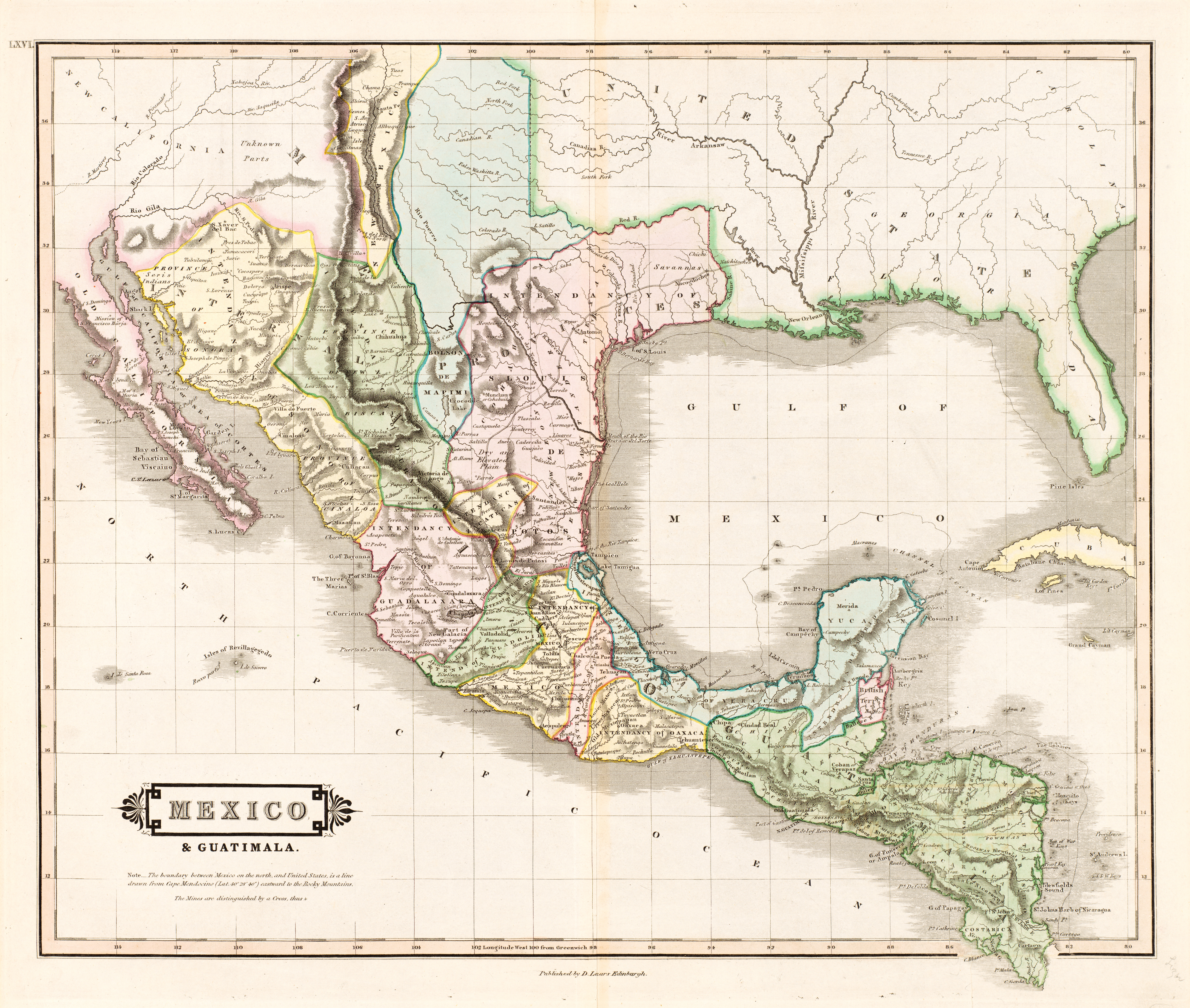
English: Mexico & Guatimala [sic] |
||||||||||||||||||||||||||
| Deskrivadur |
English: The creator of this map was probably Daniel Lizars II (1793-1875), the son of Edinburgh map engraver and publisher Daniel Lizars I (1754-1812) and younger brother of William Home Lizars (1788-1859). Shortly after producing the map, Daniel II went bankrupt in 1832 and emigrated to Canada in 1833. Lizars' map shows Mexico's administrative districts as Intendencies (Intendencias) and Internal Provinces (Provincias Internas) dating from the Spanish era. His depiction of the area that became Texas is notably jarring to modern viewers because his map further exaggerated some of the cartographic errors of his predecessors and contemporaries: particularly, a southerly "dip" of the middle Red River and the southerly courses of the Trinity, Brazos, and Colorado Rivers (which actually flow southeasterly). Settlements shown include Nacogdoches, "St." Antonio, and "Loredo". Interestingly, Lizars included the "British Territory" that became British Honduras or Belize. British logging settlements existed in the territory by the late eighteenth century and, although the British government had been hesitant to create a colony for fear of provoking the Spanish, settlers there were largely self-governing. |
||||||||||||||||||||||||||
| Deiziad | circa 1831 | ||||||||||||||||||||||||||
| Mammenn | UTA Libraries Cartographic Connections: kartenn / text | ||||||||||||||||||||||||||
| Krouet gant |
|
||||||||||||||||||||||||||
| Akuizitadur |
English: The University of Texas at Arlington Libraries Special Collections, Gift of Virginia Garrett |
||||||||||||||||||||||||||
| Geotemporal data | |||||||||||||||||||||||||||
| Map location |
Mec'hiko Guatemala Texas |
||||||||||||||||||||||||||
| Georeferencing | If inappropriate please set warp_status = skip to hide. | ||||||||||||||||||||||||||
| Bibliographic data | |||||||||||||||||||||||||||
| Embannadenn |
The Edinburgh Geographical and Historical Atlas |
||||||||||||||||||||||||||
| Aozer |
John Hamilton |
||||||||||||||||||||||||||
| Lec'h an embannadur |
Dinedin Londrez Dulenn |
||||||||||||||||||||||||||
| Embanner |
John Hamilton Whittaker, Treacher & Co. W. Curry, Jun. & Co. |
||||||||||||||||||||||||||
| Archival data | |||||||||||||||||||||||||||
| Dastumad |
|
||||||||||||||||||||||||||
| Mentoù | uhelder: 42 cm; led: 51,5 cm | ||||||||||||||||||||||||||
| Mod | gravure colorée sur papier | ||||||||||||||||||||||||||
| artwork-references |
Worms, Laurence; Ashley Baynton-Williams (2011) British Map Engravers, Londrez: Rare Book Society, pp. 406–409 |
||||||||||||||||||||||||||
| Stummoù all | |||||||||||||||||||||||||||
.jpg)
Aotre-implijout

|
This file was provided to Wikimedia Commons by the University of Texas at Arlington Libraries as part of a cooperation project. The University of Texas at Arlington Libraries is part of the University of Texas at Arlington, a public research university located in Arlington, Texas.
|
|
The author died in 1875, so this work is in the public domain in its country of origin and other countries and areas where the copyright term is the author's life plus 100 years or fewer. This work is in the public domain in the United States because it was published (or registered with the U.S. Copyright Office) before January 1, 1929. | |
| Rummet eo bet ar restr-mañ e-touez ar restroù hep strishadurioù implij anavezet evit ar pezh a sell ouzh ar gwirioù aozer, ha kement-se evit an holl wirioù kar ha stag. | |
Istor ar restr
Klikañ war un deiziad/eur da welet ar restr evel ma oa da neuze.
| Deiziad/Eur | Munud | Mentoù | Implijer | Notenn | |
|---|---|---|---|---|---|
| red | 13 Gou 2019 da 13:26 | | 6 185 × 5 238 (11,59 Mio) | Michael Barera | == {{int:filedesc}} == {{Map |title = ''Mexico & Guatimala'' [sic] |description = {{en|The creator of this map was probably Daniel Lizars II (1793-1875), the son of Edinburgh map engraver and publisher Daniel Lizars I (1754-1812) and younger brother of William Home Lizars (1788-1859). Shortly after producing the map, Daniel II went bankrupt in 1832 and emigrated to Canada in 1833. Lizars' map shows Mexico's administrative districts as Intendencies (''Intendencias'') and In... |
Implij ar restr
Pajenn ebet ne implij ar restr-mañ.
Implij hollek ar restr
Ober a ra ar wikioù da-heul gant ar restr-mañ :
- Implij war en.wikipedia.org
- Implij war es.wikipedia.org
- Implij war hr.wikipedia.org
- Implij war sh.wikipedia.org