
Restr:EasternRomanEmpire.png
N'haller ket gwellaat ar pizhder.
EasternRomanEmpire.png (250 × 175 piksel, ment ar restr : 7 Kio, seurt MIME : image/png)
![]()
| Tennet eo ar restr-mañ eus Wikimedia Commons ha gallout a ra bezañ implijet evit raktresoù all. Diskouezet eo deskrivadur he fajenn zeskrivañ amañ dindan. |

|
This map has been uploaded by Electionworld from en.wikipedia.org to enable the |

|
The copyright holder of this work allows anyone to use it for any purpose including unrestricted redistribution, commercial use, and modification.
|
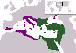
The territory in green represents the core areas held by the Eastern Roman Empire before the Muslim conquests The territory in purple represents the greatest extent of the Byzantine Empire under Emperor Justinian I
Istor ar restr
Klikañ war un deiziad/eur da welet ar restr evel ma oa da neuze.
| Deiziad/Eur | Munud | Mentoù | Implijer | Notenn | |
|---|---|---|---|---|---|
| red | 13 Kzu 2006 da 18:27 | | 250 × 175 (7 Kio) | Electionworld | {{ew|en|24630}} {{CopyrightedFreeUse-User|24630}} The territory in green represents the core areas held by the Eastern Roman Empire before the Muslim conquests The territory in purple represents the greatest extent of the Byzantine Empire unde |
Implij ar restr
Pajenn ebet ne implij ar restr-mañ.
Implij hollek ar restr
Ober a ra ar wikioù da-heul gant ar restr-mañ :
- Implij war da.wikipedia.org
- Implij war en.wiktionary.org
- Implij war gd.wikipedia.org
- Implij war lv.wikipedia.org
- Implij war no.wikipedia.org
- Implij war ru.wiktionary.org
- Implij war sl.wikipedia.org
- Implij war sq.wikipedia.org
- Implij war sv.wikipedia.org
- Implij war vi.wikipedia.org
- Implij war zh.wiktionary.org