
Restr:Duchy of Prussia.svg

Ment rakwel PNG ar restr SVG : 610 × 588 piksel. pizhderioù all : 249 × 240 piksel | 498 × 480 piksel | 797 × 768 piksel | 1 062 × 1 024 piksel | 2 125 × 2 048 piksel.
Restr orin (restr SVG file, pizhder 610 × 588 piksel, ment ar restr : 55 Kio)
![]()
| Tennet eo ar restr-mañ eus Wikimedia Commons ha gallout a ra bezañ implijet evit raktresoù all. Diskouezet eo deskrivadur he fajenn zeskrivañ amañ dindan. |
Diverradur
| Deskrivadur |
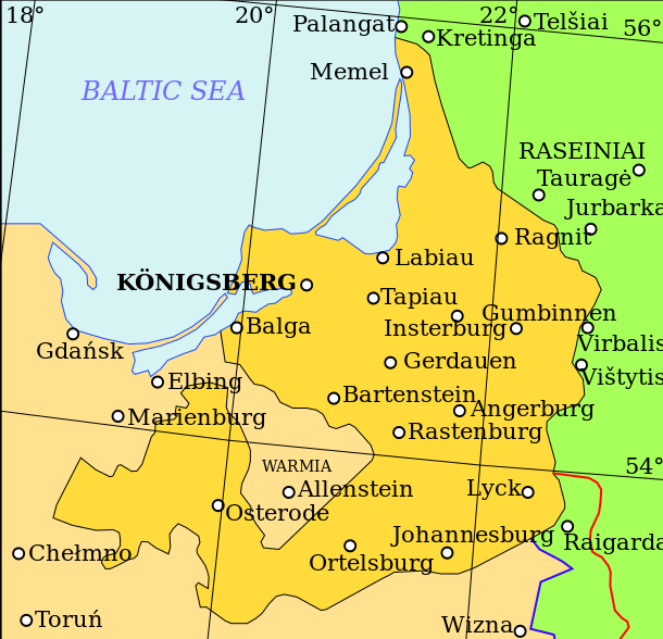
English: Map showing the Duchy of Prussia, at an indeterminable date. Place names inside the Duchy are given in German, as are Elbing and Marienburg. Other names are modern.
Territory of the Duchy of Prussia Territory of the Kingdom of Poland before the Union of Lublin Territory of the Grand Duchy of Lithuania before the Union of Lublin Polish-Lithuanian border before the Union of Lublin Polish-Lithuanian border after the Union of Lublin |
| Deiziad | |
| Mammenn | Own work based on: (lituaneg) (2001) Lietuvos istorijos atlasas, Vilnius: Vaga, pp. 16—17 |
| Aozer | Grandiose |
| Stummoù all |
|
| SVG genesis |

| File | Type | Details |
|---|---|---|
| File:Polish-Lithuania map (1450-1600).svg | Large SVG | Map showing conflicts and territorial changes on the Polish-Lithuanian—Russian border, 1450–1600 |
| File:Duchy of Prussia.svg | Small SVG | Map of the Duchy of Prussia |
| File:Livonian war map (1558-1560).svg | Small SVG | Map showing campaigns in Livonia, 1558–1560. |
| File:Map of Poland and Lithuania after the Union of Lublin (1569).svg | Large SVG | Map of the w:Polish-Lithuanian Commonwealth after the Union of Lublin in 1569. |
| File:Livonian war map (1570-1577).svg | Small SVG | Map showing areas of Russian and Polish-Lithuanian forces, 1570–1577. |
| File:Campaigns of Stefan Batory.svg | Small SVG | Map of the campaign of Stefan Batory in Livonia (1575–1580). |
| File:Map of Poland and Lithuania in 1600.svg | Small SVG | Map of Livonia in 1600 |
| See also: User:Halibutt/maps, by Halibutt (kaozeal · degasadennoù). | ||
.svg)
.svg)
.svg)
.svg)
Aotre-implijout
Evel perc'henn eus ar gwirioù oberour, e embannan an oberenn-mañ dindan an aotre-implijout da-heul :
Emañ ar restr-mañ dindan an aotre-implijout Creative Commons Deroadenn-Kenrannañ 3.0 Unported
- Gallout a rit :
- eskemm – eilañ, skignañ ha treuzkas an oberenn-mañ
- kemmañ – azasaat an oberenn-mañ
- diouzh ma heuilhit kement-mañ :
- deroadenn – Rankout a rit reiñ an titouroù perc'henniezh rekis diwar-benn an aozer, pourchas ul liamm war-zu an aotre-implijout ha merkañ hag-eñ ez eus bet graet kemmoù. Gallout a rit en ober en un doare reizh met hep lakaat da grediñ ez oc'h bet aprouet gantañ pe ez eo aprouet gantañ implij an oberenn-mañ.
- eskemmañ rik-ha-rik – Ma tegasit kemmoù, ma treuzfurmit pe ma savit un dra bennak diwar an oberenn-mañ e rankit skignañ an oberenn krouet ganeoc'h dindan an hevelep aotre-implijout pe un aotre-implijout kar-tost d'an hini orin.
Istor ar restr
Klikañ war un deiziad/eur da welet ar restr evel ma oa da neuze.
| Deiziad/Eur | Munud | Mentoù | Implijer | Notenn | |
|---|---|---|---|---|---|
| red | 20 Ebr 2011 da 10:07 | | 610 × 588 (55 Kio) | Grandiose | Correct spelling |
| 19 Ebr 2011 da 12:44 |  | 610 × 588 (54 Kio) | Grandiose | Lines on longitude and latitude; other important fixes. | |
| 19 Ebr 2011 da 12:36 |  | 610 × 588 (1,1 Mio) | Grandiose | Fix text locations | |
| 19 Ebr 2011 da 12:33 |  | 610 × 588 (1,1 Mio) | Grandiose |
Implij ar restr
Implijout a ra ar bajenn da heul ar restr-mañ :
Implij hollek ar restr
Ober a ra ar wikioù da-heul gant ar restr-mañ :
- Implij war ar.wikipedia.org
- Implij war ast.wikipedia.org
- Implij war ca.wikipedia.org
- Implij war cs.wikipedia.org
- Implij war de.wikipedia.org
- Implij war el.wikipedia.org
- Implij war en.wikipedia.org
- Implij war eu.wikipedia.org
- Implij war fa.wikipedia.org
- Implij war fi.wikipedia.org
- Implij war gl.wikipedia.org
- Implij war he.wikipedia.org
- Implij war hr.wikipedia.org
- Implij war hu.wikipedia.org
- Implij war is.wikipedia.org
- Implij war it.wikipedia.org
- Implij war ja.wikipedia.org
- Implij war ko.wikipedia.org
- Implij war lt.wikipedia.org
- Implij war mk.wikipedia.org
- Implij war rue.wikipedia.org
- Implij war ru.wikipedia.org
- Implij war sc.wikipedia.org
- Implij war sh.wikipedia.org
- Implij war sv.wikipedia.org
- Implij war th.wikipedia.org
- Implij war tr.wikipedia.org
- Implij war uk.wikipedia.org
- Implij war vi.wikipedia.org
- Implij war www.wikidata.org
- Implij war zh.wikipedia.org