
Restr:Alpes.jpg

Restr orin (1 108 × 724 piksel, ment ar restr : 233 Kio, seurt MIME : image/jpeg)
![]()
| Tennet eo ar restr-mañ eus Wikimedia Commons ha gallout a ra bezañ implijet evit raktresoù all. Diskouezet eo deskrivadur he fajenn zeskrivañ amañ dindan. |
Diverradur
| Deskrivadur |
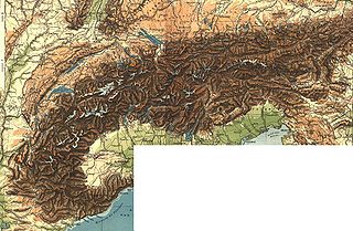
Français : Carte géographique des Alpes. |
| Deiziad | |
| Mammenn | Scan de Diercke Schul-Atlas für Höhere Lehranstalten de 1907 par Yann Forget. |
| Aozer | Diercke Schul-Atlas für Höhere Lehranstalten |

|
This old map image could be re-created using vector graphics as an SVG file. This has several advantages; see Commons:Media for cleanup for more information. If an SVG form of this image is available, please upload it and afterwards replace this template with
{{vector version available|new image name}}.
It is recommended to name the SVG file “Alpes.svg”—then the template Vector version available (or Vva) does not need the new image name parameter. |


Aotre-implijout
This image is in the public domain because it is a mere mechanical scan or photocopy of a public domain original, or – from the available evidence – is so similar to such a scan or photocopy that no copyright protection can be expected to arise. The original itself is in the public domain for the following reason:
This tag is designed for use where there may be a need to assert that any enhancements (eg brightness, contrast, colour-matching, sharpening) are in themselves insufficiently creative to generate a new copyright. It can be used where it is unknown whether any enhancements have been made, as well as when the enhancements are clear but insufficient. For known raw unenhanced scans you can use an appropriate {{PD-old}} tag instead. For usage, see Commons:When to use the PD-scan tag.  | ||||
Marilh orin ar pellgargadurioù
Transferred from fr.wikipedia to Commons.
Légende : (actu) = ceci est l'image actuelle, (suppr) = supprimer cette ancienne version, (rétab) = rétablir cette ancienne version.
Cliquez sur la date pour voir l'image copiée à cette date.
- (suppr) (actu) 1 février 2004 à 15:50 . . fr:Utilisateur:Yann Yann ( fr:Discussion_Utilisateur:Yann Discuter) . . 1108x724 (238784 octets) (Carte géographique des Alpes (grand format))
Istor ar restr
Klikañ war un deiziad/eur da welet ar restr evel ma oa da neuze.
| Deiziad/Eur | Munud | Mentoù | Implijer | Notenn | |
|---|---|---|---|---|---|
| red | 28 Gen 2006 da 20:30 | | 1 108 × 724 (233 Kio) | Maksim | La bildo estas kopiita de wikipedia:fr. La originala priskribo estas: == Description == Carte géographique des Alpes (grand format) == Source == Scan de ''Diercke Schul-Atlas für Höhere Lehranstalten'' de 1907 par Yann. == Lic |
Implij ar restr
Pajenn ebet ne implij ar restr-mañ.
Implij hollek ar restr
Ober a ra ar wikioù da-heul gant ar restr-mañ :
- Implij war es.wikipedia.org