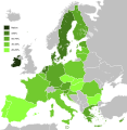
Restr:Knowledge of English EU map.svg

N’eus ket eus endalc’had ar bajenn e yezhoù all.
Eus Wikipedia

Restr orin(restr SVG file, pizhder 590 × 603 piksel, ment ar restr : 671 Kio)

Restr Wikimedia Commons

Tennet eo ar restr-mañ eus Wikimedia Commons ha gallout a ra bezañ implijet evit raktresoù all. Diskouezet eo deskrivadur he fajenn zeskrivañ amañ dindan.
This image is an information graphic created by a computer program from data sets or formulas that have not been fully provided on this page. In order to allow other editors to improve or build such images, and to ensure compliance with free content licenses such as the GFDL, the following should be provided:
  • Software package(s) used
  • Data sets used (if any), including pre-processing instructions
  • Sequence of commands used to create the graphic
  • Short description of any post-processing stages
Once all the above are included in the image's description page(s), please remove this template.

Deutsch  English  français  magyar  Nederlands  Plattdüütsch  suomi  македонски  русский  日本語  中文  中文(简体)‎  +/−

Diverradur

Deskrivadur
English: Map, in English of the knowledge of English language in EU.
Deutsch: Karte, die auf Englisch Kenntnisse der englischen Sprache in der EU zeigt.
Français : Carte des connaissances de l'anglais, en anglais, dans l'Union européenne.
Deiziad (UTC)
Mammenn
Aozer
Stummoù all


This is a retouched picture, which means that it has been digitally altered from its original version. Modifications: Hybridised to make vector version of English map. The original can be viewed here: Knowledge English EU map.png. Modifications made by Alphathon.

w:br:Creative Commons
deroadenn eskemmañ rik-ha-rik
Emañ ar restr-mañ dindan an aotre-implijout Creative Commons Deroadenn-Kenrannañ 3.0 Unported
Gallout a rit :
  • eskemm – eilañ, skignañ ha treuzkas an oberenn-mañ
  • kemmañ – azasaat an oberenn-mañ
diouzh ma heuilhit kement-mañ :
  • deroadenn – Rankout a rit reiñ an titouroù perc'henniezh rekis diwar-benn an aozer, pourchas ul liamm war-zu an aotre-implijout ha merkañ hag-eñ ez eus bet graet kemmoù. Gallout a rit en ober en un doare reizh met hep lakaat da grediñ ez oc'h bet aprouet gantañ pe ez eo aprouet gantañ implij an oberenn-mañ.
  • eskemmañ rik-ha-rik – Ma tegasit kemmoù, ma treuzfurmit pe ma savit un dra bennak diwar an oberenn-mañ e rankit skignañ an oberenn krouet ganeoc'h dindan an hevelep aotre-implijout pe un aotre-implijout kar-tost d'an hini orin.

Marilh orin ar pellgargadurioù

This image is a derivative work of the following images:

  • File:Knowledge_of_German_EU_map.png licensed with PD-self
    • 2009-05-23T22:36:14Z HernauMan 1218x1245 (56214 Bytes) {{Information |Description={{en|1=Knowledge of German language in EU with Croatia, Bosnia and Herzegovina, Switzerland and Turkey. }} |Source=Own work by uploader |Author=[[User:HernauMan|HernauMan]] |Date=2009-05-15 |Permiss
  • File:Knowledge_English_EU_map.png licensed with PD-self
    • 2010-08-13T09:57:14Z RoseAphro 1218x1245 (78412 Bytes) Reverted to version as of 11:13, 2 January 2009 See Discussion
    • 2009-11-10T09:34:49Z Scooter20 1218x1245 (85789 Bytes) Reverted to version as of 10:56, 13 March 2009
    • 2009-07-07T03:55:09Z Kombie2 1218x1245 (61153 Bytes) Corrected wrong text colour in the "NA" in the legend; in an informational map, text colours should be consistent to maximize readability. Also, customarily, a forward slash is entered between the letter 'N' and the letter
    • 2009-03-13T10:56:15Z MacedonianBoy 1218x1245 (85789 Bytes) Since Croatia and Turkey are not part of the EU and they shown, and Macedonia should be since it is candidate
    • 2009-01-02T11:13:54Z The Duke of Waltham 1218x1245 (78412 Bytes) Reverted to version as of 23:47, 15 February 2008 (FYROM is not in the EU)
    • 2008-12-11T12:35:26Z MacedonianBoy 1218x1245 (85789 Bytes)
    • 2008-02-15T23:47:46Z RedCoat 1218x1245 (78412 Bytes) Add Gibraltar.
    • 2006-12-19T09:56:40Z Hoshie 1218x1245 (85776 Bytes) Added Montenegro. Under same license as orginal
    • 2006-11-12T13:50:19Z Aaker 1218x1245 (85716 Bytes) Knowledge of English in the European Union, according to: "Special Eurobarometer 243" of the European Commission with the title "Europeans and their Languages" Made by myself

Uploaded with derivativeFX

Captions

Add a one-line explanation of what this file represents

Items portrayed in this file

diskouez a ra

27 Eos 2010

Istor ar restr

Klikañ war un deiziad/eur da welet ar restr evel ma oa da neuze.

Deiziad/EurMunudMentoùImplijerNotenn
red3 C'hwe 2020 da 10:36Munud eus stumm an 3 C'hwe 2020 da 10:36590 × 603 (671 Kio)DarrancUpdate since UK left the EU
15 C'hwe 2015 da 23:30Munud eus stumm an 15 C'hwe 2015 da 23:30590 × 603 (671 Kio)LeftcryUpdate layout and information
17 Her 2011 da 11:49Munud eus stumm an 17 Her 2011 da 11:491 212 × 1 242 (552 Kio)Treehilldeletion of Turkey, I let only candidate country with an accession date planned (Croatia and Iceland).
7 Gwe 2011 da 06:34Munud eus stumm an 7 Gwe 2011 da 06:341 212 × 1 242 (552 Kio)Treehill(norway was not deleted before, maybe an error)
6 Gwe 2011 da 20:58Munud eus stumm an 6 Gwe 2011 da 20:581 212 × 1 242 (552 Kio)Treehilldeletion of Norway, as explained previously. Not an EU country (note that the name of the file is "Knowledge_of_English_EU_map.svg").
6 Gwe 2011 da 19:50Munud eus stumm an 6 Gwe 2011 da 19:501 212 × 1 242 (552 Kio)TreehillI deleted Switzerland which is neither in the EU nor a candidate country.
12 Gou 2011 da 11:12Munud eus stumm an 12 Gou 2011 da 11:121 212 × 1 242 (552 Kio)J intelaAdded Norway and Switzerland http://en.wikipedia.org/wiki/List_of_countries_by_English-speaking_population
8 Ebr 2011 da 19:08Munud eus stumm an 8 Ebr 2011 da 19:081 212 × 1 242 (552 Kio)AlphathonImproved British Isles
27 Eos 2010 da 17:42Munud eus stumm an 27 Eos 2010 da 17:421 212 × 1 242 (520 Kio)Alphathon{{Information |Description={{en|1=Knowledge of English language in EU}} |Source=*File:Knowledge_of_German_EU_map.png *File:Knowledge_English_EU_map.png |Date=2010-08-27 17:41 (UTC) |Author=*File:Knowledge_of_German_EU_map.png: [[User:Her

Pajenn ebet ne implij ar restr-mañ.

Implij hollek ar restr

Ober a ra ar wikioù da-heul gant ar restr-mañ :

Gwelet muioc'h eus implij hollek ar restr-mañ.

Metaroadennoù