
Restr:Territorio libero di Trieste carta.png
Restr orin (511 × 804 piksel, ment ar restr : 104 Kio, seurt MIME : image/png)
![]()
| Tennet eo ar restr-mañ eus Wikimedia Commons ha gallout a ra bezañ implijet evit raktresoù all. Diskouezet eo deskrivadur he fajenn zeskrivañ amañ dindan. |
Diverradur
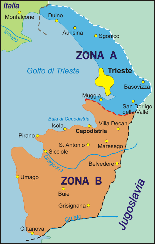
Map of the Free Territory of Trieste (1947-1954), with zone delimitation, in Italian. Own adaptation of http://sl.wikipedia.org/wiki/Slika:STO.png from the Slovene Wikipedia, by kind permission of the original author.
Carta del Territorio libero di Trieste (1947-1954), con delimitazione delle zone, versione italiana. Adattamento proprio di http://sl.wikipedia.org/wiki/Slika:STO.png dalla Wikipedia slovena, con permesso cortese del autore originario.
English version: Image:Free_Territory_of_Trieste_map.png German version: Image:Freies_Territorium_Triest_Karte.png
Aotre-implijout
| Me, perc'henn war gwirioù an oberenn-mañ, a laka anezhi en domani foran. Talvezout a ra kement-mañ evit ar bed a-bezh. E broioù zo e c'hall kement-mañ bezañ dibosupl ent lezennel; mard emañ kont evel-se : Reiñ a ran aotre d'an holl da implijout an oberenn-mañ evit ober ne vern petra, hep tamm bevenn ebet estreget hini al lezenn. |

|
This historical map image could be re-created using vector graphics as an SVG file. This has several advantages; see Commons:Media for cleanup for more information. If an SVG form of this image is available, please upload it and afterwards replace this template with
{{vector version available|new image name}}.
It is recommended to name the SVG file “Territorio libero di Trieste carta.svg”—then the template Vector version available (or Vva) does not need the new image name parameter. |
Istor ar restr
Klikañ war un deiziad/eur da welet ar restr evel ma oa da neuze.
| Deiziad/Eur | Munud | Mentoù | Implijer | Notenn | |
|---|---|---|---|---|---|
| red | 6 Her 2005 da 17:04 | | 511 × 804 (104 Kio) | Alib | Map of the Free Territory of Trieste (1947-1954), with zone delimitation, in Italian. Own adaptation of http://sl.wikipedia.org/wiki/Slika:STO.png from the Slovene Wikipedia, by kind permission of the original author. Carta del Territorio libero di Tries |
Implij ar restr
Implijout a ra an 2 pajenn da heul ar restr-mañ :
Implij hollek ar restr
Ober a ra ar wikioù da-heul gant ar restr-mañ :
- Implij war be.wikipedia.org
- Implij war ca.wikipedia.org
- Implij war da.wikipedia.org
- Implij war et.wikipedia.org
- Implij war he.wikipedia.org
- Implij war it.wikipedia.org
- Implij war ka.wikipedia.org
- Implij war ko.wikipedia.org
- Implij war li.wikipedia.org
- Implij war lt.wikipedia.org
- Implij war no.wikipedia.org
- Implij war pl.wikipedia.org
- Implij war pt.wikipedia.org
- Implij war ru.wikipedia.org
- Implij war sc.wikipedia.org
- Implij war sh.wikipedia.org
- Implij war sl.wikipedia.org
- Implij war sr.wikipedia.org
- Implij war www.wikidata.org
- Implij war wuu.wikipedia.org