
Restr:Tangier Zone txu-oclc-6949452-ni30-1.jpg

Ment ar rakweled-mañ : 410 × 599 piksel. pizhderioù all : 164 × 240 piksel | 329 × 480 piksel | 949 × 1 386 piksel.
Restr orin (949 × 1 386 piksel, ment ar restr : 1,2 Mio, seurt MIME : image/jpeg)
![]()
| Tennet eo ar restr-mañ eus Wikimedia Commons ha gallout a ra bezañ implijet evit raktresoù all. Diskouezet eo deskrivadur he fajenn zeskrivañ amañ dindan. |
Diverradur
| Deskrivadur |
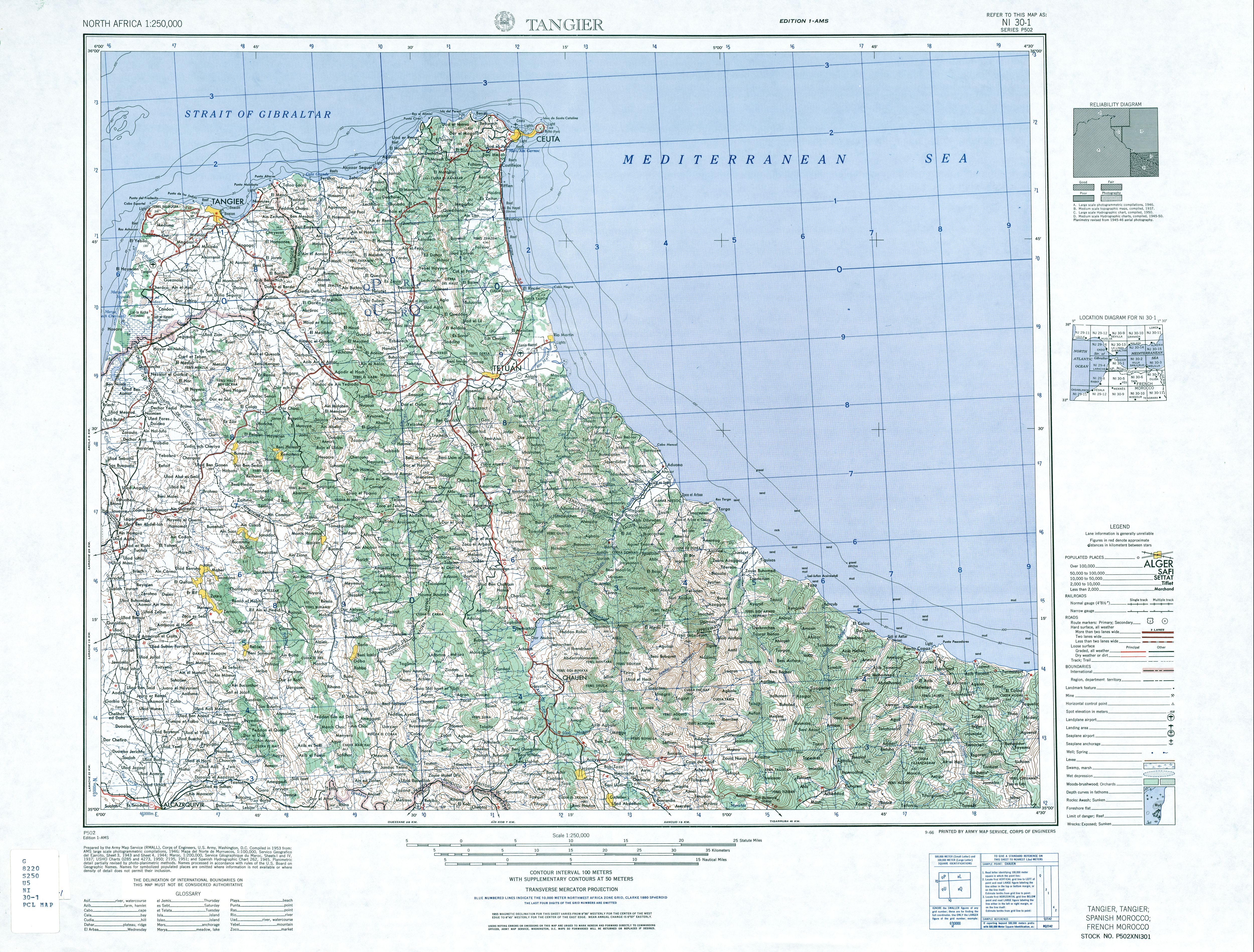
English: map of the area of the former International Zone of Tangier, Morocco |
| Deiziad | |
| Mammenn | http://www.lib.utexas.edu/maps/ams/north_africa/txu-oclc-6949452-ni30-1.jpg |
| Aozer | Army Map Service |
Aotre-implijout
This file is a work of a U.S. Army soldier or employee, taken or made as part of that person's official duties. As a work of the U.S. federal government, it is in the public domain in the United States.
|
 |
-
Istor ar restr
Klikañ war un deiziad/eur da welet ar restr evel ma oa da neuze.
| Deiziad/Eur | Munud | Mentoù | Implijer | Notenn | |
|---|---|---|---|---|---|
| red | 29 Du 2017 da 07:14 | | 949 × 1 386 (1,2 Mio) | ديفيد عادل وهبة خليل 2 | Removed border by cropping 3 % horizontally and 2 % vertically using CropTool with precise mode. |
| 6 Mez 2010 da 19:40 |  | 976 × 1 419 (1,26 Mio) | Ratzer | {{Information |Description={{en|1=map of the area of the former International Zone of Tangier, Morocco}} |Source=http://www.lib.utexas.edu/maps/ams/north_africa/txu-oclc-6949452-ni30-1.jpg |Author=Army Map Service |Date=1953 |Permission= |other_versions= |
Implij ar restr
Implijout a ra ar bajenn da heul ar restr-mañ :
Implij hollek ar restr
Ober a ra ar wikioù da-heul gant ar restr-mañ :
- Implij war ar.wikipedia.org
- Implij war de.wikipedia.org
- Implij war en.wikipedia.org
- Implij war fr.wikipedia.org
- Implij war id.wikipedia.org
- Implij war it.wikipedia.org
- Implij war ja.wikipedia.org
- Implij war nl.wikipedia.org
- Implij war pl.wikipedia.org
- Implij war pt.wikipedia.org
- Implij war ru.wikipedia.org
- Implij war simple.wikipedia.org
- Implij war uk.wikipedia.org
- Implij war ur.wikipedia.org
- Implij war zh.wikipedia.org