
Restr:SyltSat.jpg
Ment ar rakweled-mañ : 445 × 600 piksel. pizhderioù all : 178 × 240 piksel | 356 × 480 piksel | 668 × 900 piksel.
Restr orin (668 × 900 piksel, ment ar restr : 40 Kio, seurt MIME : image/jpeg)
![]()
| Tennet eo ar restr-mañ eus Wikimedia Commons ha gallout a ra bezañ implijet evit raktresoù all. Diskouezet eo deskrivadur he fajenn zeskrivañ amañ dindan. |
Diverradur
| Deskrivadur |
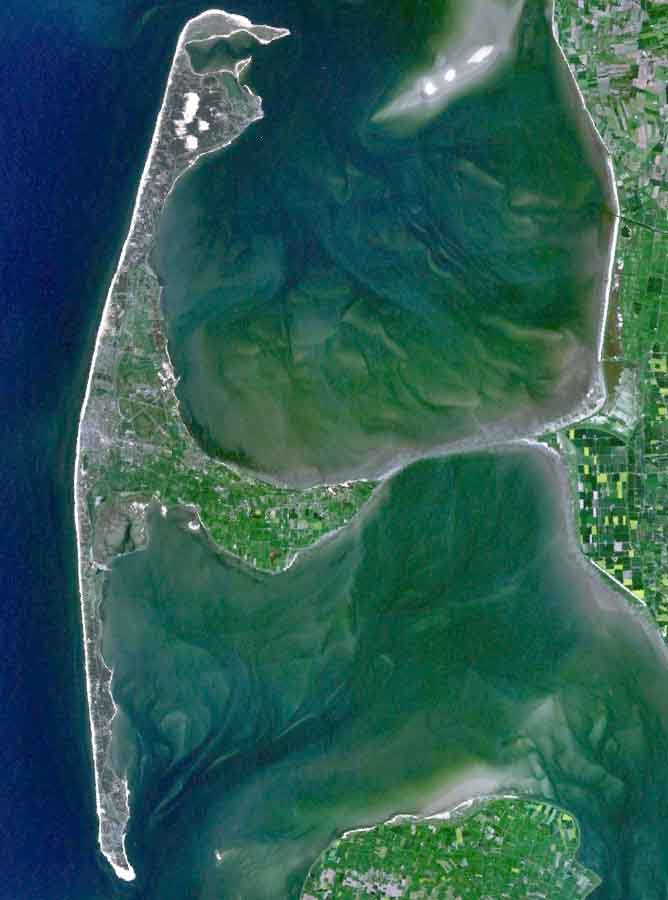
English: The Island of Sylt in Northern Germany from the South. Satellite view. |
| Deiziad | 24 Ebrel 2005 (upload date) |
| Mammenn | Satellite imagery taken from NASA World Wind software (by screenshot) |
| Aozer | NASA |
Aotre-implijout
| This image is in the public domain because it is a screenshot from NASA’s globe software World Wind using a public domain layer, such as Blue Marble, MODIS, Landsat, SRTM, USGS or GLOBE.
|
 |
| Annotations | This image is annotated: View the annotations at Commons |
Istor ar restr
Klikañ war un deiziad/eur da welet ar restr evel ma oa da neuze.
| Deiziad/Eur | Munud | Mentoù | Implijer | Notenn | |
|---|---|---|---|---|---|
| red | 4 Eos 2006 da 19:39 | | 668 × 900 (40 Kio) | Ollio | original work of NASA - public domain picture made brigther by O. Lippuner (User --~~~~), without changing public domain status |
| 24 Ebr 2005 da 14:01 |  | 668 × 900 (350 Kio) | SeballaOne~commonswiki | The Island of Sylt in Northern Germany from the South. Created with World Wind {{PD-USGov-NASA}} Category:Islands Category:Satellite photos |
Implij ar restr
Implijout a ra ar bajenn da heul ar restr-mañ :
Implij hollek ar restr
Ober a ra ar wikioù da-heul gant ar restr-mañ :
- Implij war af.wikipedia.org
- Implij war ar.wikipedia.org
- Implij war ca.wikipedia.org
- Implij war da.wikipedia.org
- Implij war de.wikipedia.org
- Implij war en.wikipedia.org
- Implij war eo.wikipedia.org
- Implij war es.wikipedia.org
- Implij war fa.wikipedia.org
- Implij war frr.wikipedia.org
- Implij war fr.wikipedia.org
- Implij war fy.wikipedia.org
- Implij war is.wikipedia.org
- Implij war it.wikipedia.org
- Implij war ko.wikipedia.org
- Implij war ksh.wikipedia.org
- Implij war mk.wikipedia.org
- Implij war nds.wikipedia.org
- Implij war nn.wikipedia.org
- Implij war no.wikipedia.org
- Implij war pnb.wikipedia.org
- Implij war pt.wikipedia.org
- Implij war stq.wikipedia.org
- Implij war sv.wikipedia.org
- Implij war xmf.wikipedia.org
- Implij war zh.wikipedia.org