
Restr:Sunda strait map v3.png
N'haller ket gwellaat ar pizhder.
Sunda_strait_map_v3.png (489 × 600 piksel, ment ar restr : 310 Kio, seurt MIME : image/png)
![]()
| Tennet eo ar restr-mañ eus Wikimedia Commons ha gallout a ra bezañ implijet evit raktresoù all. Diskouezet eo deskrivadur he fajenn zeskrivañ amañ dindan. |
Diverradur
| Deskrivadur |
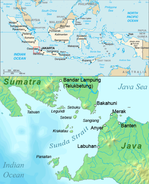
English: Map of the Sunda Strait, Indonesia. |
|||||||
| Deiziad | ||||||||
| Mammenn | Combination of CIA World Factbook map and Demis Map Server (http://www2.demis.nl/mapserver/mapper.asp) data with additional annotations and modifications by self. | |||||||
| Aozer | ChrisO | |||||||
| Aotre (Adimplij ar restr-mañ) |
|
|||||||
| Stummoù all | lower part (demis map) only: File:Sunda strait map v4.png |

Istor ar restr
Klikañ war un deiziad/eur da welet ar restr evel ma oa da neuze.
| Deiziad/Eur | Munud | Mentoù | Implijer | Notenn | |
|---|---|---|---|---|---|
| red | 2 Kzu 2006 da 10:39 | | 489 × 600 (310 Kio) | Burgundo | Caricato da en.wiki |
Implij ar restr
Implijout a ra an 2 pajenn da heul ar restr-mañ :
Implij hollek ar restr
Ober a ra ar wikioù da-heul gant ar restr-mañ :
- Implij war ar.wikipedia.org
- Implij war ast.wikipedia.org
- Implij war ban.wikipedia.org
- Implij war ba.wikipedia.org
- Implij war bcl.wikipedia.org
- Implij war bg.wikipedia.org
- Implij war ca.wikipedia.org
- Implij war cs.wikipedia.org
- Implij war da.wikipedia.org
- Implij war el.wikipedia.org
- Implij war en.wikipedia.org
- Implij war en.wikinews.org
- Implij war es.wikipedia.org
- Implij war fa.wikipedia.org
- Implij war fr.wikipedia.org
- Implij war fy.wikipedia.org
- Implij war gl.wikipedia.org
- Implij war hak.wikipedia.org
- Implij war hi.wikipedia.org
- Implij war hu.wikipedia.org
- Implij war hy.wikipedia.org
- Implij war id.wikipedia.org
- Implij war incubator.wikimedia.org
- Implij war it.wikipedia.org
- Implij war ja.wikipedia.org
- Implij war kk.wikipedia.org
- Implij war ko.wikipedia.org
Gwelet muioc'h eus implij hollek ar restr-mañ.