
Restr:Sëlva Wolkenstein Selva di Val Gardena Sella.jpg

Ment ar rakweled-mañ : 800 × 415 piksel. pizhderioù all : 320 × 166 piksel | 640 × 332 piksel | 1 024 × 531 piksel | 1 280 × 664 piksel | 2 560 × 1 327 piksel | 11 723 × 6 078 piksel.
Restr orin (11 723 × 6 078 piksel, ment ar restr : 51,52 Mio, seurt MIME : image/jpeg)
![]()
| Tennet eo ar restr-mañ eus Wikimedia Commons ha gallout a ra bezañ implijet evit raktresoù all. Diskouezet eo deskrivadur he fajenn zeskrivañ amañ dindan. |
Diverradur
| Deskrivadur |
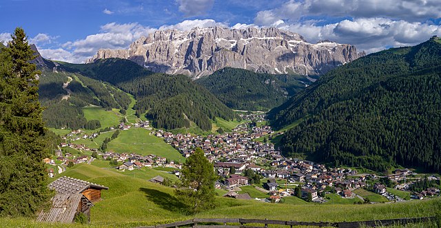
English: View of the town of Sëlva with the Cir and Sella mountain groups
Deutsch: Ansicht von Wolkenstein in Gröden und die Sellagruppe in Südtirol
Italiano: Selva di Val Gardena con i gruppi montani del Cir e Sella e l'Alpe Jac visti dal monte Pic |
||||||
| Deiziad | |||||||
| Mammenn | Labour an-unan | ||||||
| Aozer |
|
||||||
| Aotre (Adimplij ar restr-mañ) |
Own work, attribution required (Multi-license with GFDL and Creative Commons CC-BY 2.5). Capture: Photo by Wolfgang Moroder | ||||||
| Stummoù all |
 |


|
NOTE: This image is a panorama of 2 photos consisting of multiple frames that were merged or stitched in software. As a result, this image necessarily underwent some form of digital manipulation. These manipulations may include blending, blurring, cloning, and colour and perspective adjustments. As a result of these adjustments, the image content may be slightly different from reality at the points where multiple images were combined. This manipulation is often required due to lens, perspective, and parallax distortions.
|
| Lec’h luc’hskeudennerez | | Gwelet al lec’h-se e : OpenStreetMap |
|---|
Aotre-implijout
Evel perc'henn eus ar gwirioù oberour, e embannan an oberenn-mañ dindan an aotre-implijout da-heul :
Emañ ar restr-mañ dindan an aotre-implijout Creative Commons Deroadenn-Kenrannañ 3.0 Unported
- Gallout a rit :
- eskemm – eilañ, skignañ ha treuzkas an oberenn-mañ
- kemmañ – azasaat an oberenn-mañ
- diouzh ma heuilhit kement-mañ :
- deroadenn – Rankout a rit reiñ an titouroù perc'henniezh rekis diwar-benn an aozer, pourchas ul liamm war-zu an aotre-implijout ha merkañ hag-eñ ez eus bet graet kemmoù. Gallout a rit en ober en un doare reizh met hep lakaat da grediñ ez oc'h bet aprouet gantañ pe ez eo aprouet gantañ implij an oberenn-mañ.
- eskemmañ rik-ha-rik – Ma tegasit kemmoù, ma treuzfurmit pe ma savit un dra bennak diwar an oberenn-mañ e rankit skignañ an oberenn krouet ganeoc'h dindan an hevelep aotre-implijout pe un aotre-implijout kar-tost d'an hini orin.
This image has been assessed using the Quality image guidelines and is considered a Quality image.
|
Istor ar restr
Klikañ war un deiziad/eur da welet ar restr evel ma oa da neuze.
| Deiziad/Eur | Munud | Mentoù | Implijer | Notenn | |
|---|---|---|---|---|---|
| red | 16 Mez 2018 da 06:55 | | 11 723 × 6 078 (51,52 Mio) | Moroder | cloned sky |
| 16 Mez 2018 da 06:45 |  | 11 723 × 6 078 (51,4 Mio) | Moroder | =={{int:filedesc}}== {{Information |description= {{en|1=View of the town of {{w|Sëlva}} with the Cir and Sella mountain groups}} {{de|1=Ansicht von Wolkenstein in Gröden und die Sellagruppe in Südtirol}} {{it|1=Selva di Val Gardena con i gruppi montani del Cir e Sella e l'Alpe Jac visti dal monte Pic}} |date=2018-06-15 |source={{own}} |author={{User:Moroder/Template:Credits}} |Permission=Own work, attribution required (Multi-license with GFDL and Creative Commons CC-BY 2.5). Capture: ''Photo ... |
Implij ar restr
Implijout a ra ar bajenn da heul ar restr-mañ :
Implij hollek ar restr
Ober a ra ar wikioù da-heul gant ar restr-mañ :
- Implij war ar.wikipedia.org
- Implij war azb.wikipedia.org
- Implij war be.wikipedia.org
- Implij war bg.wikipedia.org
- Implij war ca.wikipedia.org
- Implij war ceb.wikipedia.org
- Implij war ce.wikipedia.org
- Implij war de.wikipedia.org
- Implij war de.wikivoyage.org
- Implij war el.wikipedia.org
- Implij war en.wikipedia.org
- Implij war eo.wikipedia.org
- Implij war es.wikipedia.org
- Implij war eu.wikipedia.org
- Implij war fr.wikipedia.org
- Implij war hu.wikipedia.org
- Implij war hy.wikipedia.org
- Implij war ia.wikipedia.org
- Implij war it.wikipedia.org
- Implij war it.wikivoyage.org
- Implij war ko.wikipedia.org
- Implij war lld.wikipedia.org
- Implij war lmo.wikipedia.org
- Implij war no.wikipedia.org
- Implij war pl.wikipedia.org
- Implij war ru.wikipedia.org
- Implij war sr.wikipedia.org
- Implij war tl.wikipedia.org
- Implij war tr.wikipedia.org
- Implij war tt.wikipedia.org
- Implij war uk.wikipedia.org
- Implij war uz.wikipedia.org
- Implij war vec.wikipedia.org
Gwelet muioc'h eus implij hollek ar restr-mañ.