
Restr:Rodrigues 76.jpg
N'haller ket gwellaat ar pizhder.
Rodrigues_76.jpg (409 × 405 piksel, ment ar restr : 151 Kio, seurt MIME : image/jpeg)
![]()
| Tennet eo ar restr-mañ eus Wikimedia Commons ha gallout a ra bezañ implijet evit raktresoù all. Diskouezet eo deskrivadur he fajenn zeskrivañ amañ dindan. |
Diverradur
| Deskrivadur |
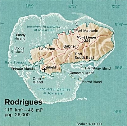
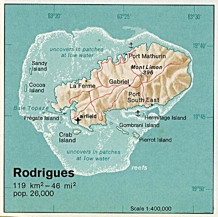
Deutsch: Karte von Rodrigues (Mauritius) im Indischen Ozean
English: Map of Rodrigues Island (Mauritius) in the Indian Ocean |
| Deiziad | |
| Mammenn | The Indian Ocean Atlas, CIA, 1976. Retrieved from: University of Texas Libraries, Perry-Castañeda Library Map Collection: Mauritius Maps |
| Aozer | CIA |
Aotre-implijout
| This image is a work of a Central Intelligence Agency employee, taken or made as part of that person's official duties. As a Work of the United States Government, this image or media is in the public domain in the United States.
|

|
Istor ar restr
Klikañ war un deiziad/eur da welet ar restr evel ma oa da neuze.
| Deiziad/Eur | Munud | Mentoù | Implijer | Notenn | |
|---|---|---|---|---|---|
| red | 1 Du 2008 da 21:15 | | 409 × 405 (151 Kio) | Snowmanradio~commonswiki | Upload a new version with border fully cropped. |
| 1 Du 2008 da 21:11 |  | 411 × 406 (153 Kio) | Snowmanradio~commonswiki | Uploaded a new version with the border cropped. Same copyright as original image. |
Implij ar restr
Implijout a ra ar bajenn da heul ar restr-mañ :
Implij hollek ar restr
Ober a ra ar wikioù da-heul gant ar restr-mañ :
- Implij war ceb.wikipedia.org
- Implij war cs.wikipedia.org
- Implij war da.wikipedia.org
- Implij war el.wikipedia.org
- Implij war en.wikipedia.org
- Implij war eo.wikipedia.org
- Implij war fi.wikipedia.org
- Implij war fr.wikipedia.org
- Implij war gl.wikipedia.org
- Implij war it.wikipedia.org
- Implij war ko.wikipedia.org
- Implij war lt.wikipedia.org
- Implij war pt.wikipedia.org
- Implij war sr.wikipedia.org
- Implij war sv.wikipedia.org
- Implij war tr.wikipedia.org
- Implij war uk.wikipedia.org
- Implij war yo.wikipedia.org
- Implij war zh.wikipedia.org