
Restr:Passchendaele aerial view.jpg
Restr orin (500 × 674 piksel, ment ar restr : 317 Kio, seurt MIME : image/jpeg)
![]()
| Tennet eo ar restr-mañ eus Wikimedia Commons ha gallout a ra bezañ implijet evit raktresoù all. Diskouezet eo deskrivadur he fajenn zeskrivañ amañ dindan. |
|

|
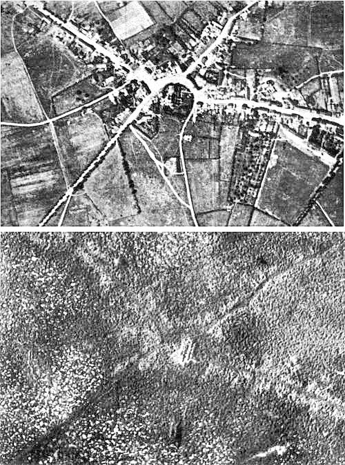
This image has been assessed under the valued image criteria and is considered the most valued image on Commons within the scope: the Battle of Passchendaele. You can see its nomination here. |
| Deskrivadur |
English: Aerial view of the village of Passchendaele (north is to the right of the photo) before and after the Third Battle of Ypres, 1917.
Français : Vue aerienne du village de Passendale, avant et après la troisième bataille d'Ypres, en 1917. Le nord est à droite sur les photos. |
|||
| Deiziad | ||||
| Mammenn |
|
|||
| Aozer | Photographer not identified. "Official photograph". | |||
| Aotre (Adimplij ar restr-mañ) |
|
|||
| Stummoù all |
|


| Lec’h luc’hskeudennerez | | Gwelet al lec’h-se e : OpenStreetMap |
|---|
Istor ar restr
Klikañ war un deiziad/eur da welet ar restr evel ma oa da neuze.
| Deiziad/Eur | Munud | Mentoù | Implijer | Notenn | |
|---|---|---|---|---|---|
| red | 22 Kzu 2011 da 17:33 | | 500 × 674 (317 Kio) | Soerfm | Sharpness |
| 25 Ebr 2005 da 11:23 |  | 500 × 674 (290 Kio) | Gsl~commonswiki | Second version: Lightened and set levels. Sharpened slightly (by w:User:Ian Dunster) | |
| 25 Ebr 2005 da 11:21 |  | 500 × 674 (81 Kio) | Gsl~commonswiki | Original version from en.wikipedia.org |
Implij ar restr
Implijout a ra ar bajenn da heul ar restr-mañ :
Implij hollek ar restr
Ober a ra ar wikioù da-heul gant ar restr-mañ :
- Implij war ar.wikipedia.org
- Implij war ast.wikipedia.org
- Implij war az.wikipedia.org
- Implij war bg.wikipedia.org
- Implij war bn.wikipedia.org
- Implij war ca.wikipedia.org
- Implij war cs.wikipedia.org
- Implij war da.wikipedia.org
- Implij war de.wikipedia.org
- Implij war el.wikipedia.org
- Implij war en.wikipedia.org
- Battle of Passchendaele
- Wikipedia:Featured picture candidates/October-2004
- Wikipedia:Picture of the day/November 2004
- Wikipedia:Picture of the day/November 7, 2004
- Wikipedia:POTD/November 7, 2004
- Alexander Edwards
- Wikipedia:Picture of the day/February 2005
- Wikipedia:POTD/February 21, 2005
- Wikipedia:Picture of the day/February 21, 2005
- Wikipedia:Picture of the day/December 2005
- Wikipedia:Picture of the day/December 21, 2005
- Wikipedia:POTD/December 21, 2005
- User:Cyde/Featured pictures
- Passendale
- Portal:United Kingdom/Featured picture/12
- Portal:United Kingdom/Featured picture
- Second Battle of Passchendaele
- Wikipedia:Featured picture candidates/delist/2008
- Wikipedia:Featured picture candidates/delist/Village of Passchendaele
- User talk:Durova/Archive 61
- Wikipedia:Featured picture candidates/delist/2009
- Wikipedia:Featured picture candidates/delist/File:Passchendaele aerial view.jpg
- User:Durova/FPC survey
- Wikipedia talk:Valued picture candidates/Archive 3
- Wikipedia:Featured picture candidates/delist/2015
- Wikipedia:Featured picture candidates/delist/Passchendaele
- Night action of 1/2 December 1917
- Implij war es.wikipedia.org
- Implij war fi.wikipedia.org
- Implij war fr.wikipedia.org
- Implij war fy.wikipedia.org
- Implij war gl.wikipedia.org
Gwelet muioc'h eus implij hollek ar restr-mañ.