
Restr:New-Map-Francophone World.PNG

Ment ar rakweled-mañ : 800 × 441 piksel. pizhderioù all : 320 × 176 piksel | 640 × 353 piksel | 1 024 × 564 piksel | 1 280 × 705 piksel | 2 664 × 1 468 piksel.
Restr orin (2 664 × 1 468 piksel, ment ar restr : 93 Kio, seurt MIME : image/png)
![]()
| Tennet eo ar restr-mañ eus Wikimedia Commons ha gallout a ra bezañ implijet evit raktresoù all. Diskouezet eo deskrivadur he fajenn zeskrivañ amañ dindan. |
Diverradur
| Deskrivadur |
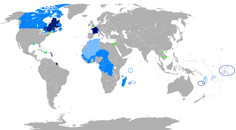
English: The French language and French creoles in the world
Regions where French or a French creole is the main language
Regions where it is an official language
Regions where it is a second language
Regions where it is a minority language
The following things have been changed from the old "Map-Francophone World.PNG":
To be modified :
Français : La langue française dans le monde
Langue maternelle
Langue officielle
Deuxième langue
Minorités francophones
Les choses suivantes ont été modifiées de l'ancien "Map-Frncophone World.PNG":
Proposition de modification : L'usage de la langue française est divers dans les pays d'Afrique subsaharienne. Par exemple, le français n'est pas la langue utilisée par défaut dans les rues sénégalaises. Tout au contraire, prétendre que le français n'est pas la langue maternelle des Gabonais reviendrait à dire que le français n'était rien de plus qu'une langue officielle dans la Bretagne des années cinquante. Ne connaissant pas la situation des autres pays, je laisse le soin à toute personne motivée de corriger cette erreur.
Català: La llengua francesa al món
Llengua materna
Llengua oficial
Segona Llengua
Minories francòfones |
| Deiziad | |
| Mammenn | Labour an-unan |
| Aozer | aaker |

|
File:New-Map-Francophone World.svg is a vector version of this file. It should be used in place of this PNG file when not inferior.
File:New-Map-Francophone World.PNG → File:New-Map-Francophone World.svg
For more information, see Help:SVG. |
 |
Aotre-implijout
| Me, perc'henn war gwirioù an oberenn-mañ, a laka anezhi en domani foran. Talvezout a ra kement-mañ evit ar bed a-bezh. E broioù zo e c'hall kement-mañ bezañ dibosupl ent lezennel; mard emañ kont evel-se : Reiñ a ran aotre d'an holl da implijout an oberenn-mañ evit ober ne vern petra, hep tamm bevenn ebet estreget hini al lezenn. |
Istor ar restr
Klikañ war un deiziad/eur da welet ar restr evel ma oa da neuze.
| Deiziad/Eur | Munud | Mentoù | Implijer | Notenn | |
|---|---|---|---|---|---|
| red | 30 Gou 2023 da 00:15 | | 2 664 × 1 468 (93 Kio) | Riad Salih | Western Sahara is an old Spanish colony, and French is not commonly used there. |
| 30 Gou 2023 da 00:10 |  | 2 664 × 1 468 (93 Kio) | Riad Salih | Since July 2023, French is no longer an official language in Mali, but a language of work. | |
| 30 Ebr 2023 da 06:49 |  | 2 664 × 1 468 (205 Kio) | Moalli | Remove green square in middle of Mediterranean, no country located there | |
| 15 Meu 2023 da 22:50 |  | 2 664 × 1 468 (105 Kio) | Kwamikagami | update some per WP-en article, though this map not used much anymore | |
| 9 Eos 2019 da 10:21 |  | 2 664 × 1 468 (120 Kio) | Benderban01 | Reverted to version as of 15:28, 17 July 2018 (UTC) | |
| 6 Eos 2019 da 09:07 |  | 2 664 × 1 468 (119 Kio) | Benderban01 | Removed the small thing on ontario. | |
| 6 Eos 2019 da 09:01 |  | 2 664 × 1 468 (119 Kio) | Benderban01 | Removed 8 provinces where french is not the official language, there 3 territorries which will spoke minority. | |
| 17 Gou 2018 da 15:28 |  | 2 664 × 1 468 (120 Kio) | Maphobbyist | Reverted to version as of 18:46, 4 January 2018 (UTC) | |
| 27 Mez 2018 da 09:53 |  | 2 664 × 1 468 (100 Kio) | Motiss | ||
| 27 Mez 2018 da 09:50 |  | 2 664 × 1 468 (120 Kio) | Motiss | Reverted to version as of 18:46, 4 January 2018 (UTC) |
Implij ar restr
Pajenn ebet ne implij ar restr-mañ.
Implij hollek ar restr
Ober a ra ar wikioù da-heul gant ar restr-mañ :
- Implij war de.wikipedia.org
- Implij war en.wikipedia.org
- Category:Wikipedians in Luxembourg
- Category:Wikipedians in Switzerland
- Category:WikiProject Luxembourg participants
- Category:WikiProject Switzerland participants
- Category:Swiss Wikipedians
- Talk:English language/Archive 18
- Talk:French language/Archive 3
- Category:Wikipedians interested in Luxembourg
- Category:Wikipedians interested in Switzerland
- Category:Luxembourg Wikipedians
- Template:Portal/doc/all
- Wikipedia:Reference desk/Archives/Humanities/2013 October 5
- User:Matt Fitzpatrick/portal images
- Wikipedia:Userboxes/Location/Luxembourg
- Wikipedia:Userboxes/Location/Switzerland
- Template:User Luxembourg/cat
- Template:User Switzerland/cat
- Template:User Luxembourg/boxes
- Template:User Switzerland/boxes
- Implij war es.wikipedia.org
- Implij war fi.wikipedia.org
- Implij war fr.wikipedia.org
- Discussion:Francophonie
- Discussion utilisateur:Le sotré
- Liste des pays ayant le français pour langue officielle
- Wikipédia:Le Bistro/24 février 2008
- Utilisateur:Brochon99/Bac à sable 5/Documentation
- Wikipédia:Le Bistro/18 décembre 2009
- Utilisateur:Kimdime/stats
- Utilisateur:Ygdrasil/http://Liste langue par nbr locuteur
- Utilisateur:Televido/Récolte
- Wikipédia:Le Bistro/25 juillet 2017
- Wikipédia:Le Bistro/30 juillet 2017
- Implij war fr.wikinews.org
- Implij war fr.wiktionary.org
- Implij war jv.wikipedia.org
- Implij war km.wikipedia.org
- Implij war nl.wikipedia.org
- Implij war so.wikipedia.org
- Implij war tum.wikipedia.org