
Restr:Maricopa County Incorporated and Planning areas Glendale highlighted.svg

Ment rakwel PNG ar restr SVG : 694 × 599 piksel. pizhderioù all : 278 × 240 piksel | 556 × 480 piksel | 889 × 768 piksel | 1 185 × 1 024 piksel | 2 371 × 2 048 piksel | 940 × 812 piksel.
Restr orin (restr SVG file, pizhder 940 × 812 piksel, ment ar restr : 1,05 Mio)
![]()
| Tennet eo ar restr-mañ eus Wikimedia Commons ha gallout a ra bezañ implijet evit raktresoù all. Diskouezet eo deskrivadur he fajenn zeskrivañ amañ dindan. |
Diverradur
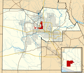
| Deskrivadur | This map shows the incorporated areas and Indian reservation boundaries in Maricopa County, Arizona, along with water bodies and major highways and roads. Glendale is highlighted in red. Other incorporated cities are shown in gray, planning area borders for these cities and Indian reservation borders are shown as solid black lines. Changes from Previous Version: Updated the maps to include water bodies and to make "less boring" than the plain black/white/gray maps. Format was updated to match standards laid out by WikiProject Maps/Conventions. Map data is based on data from the following Webpage: Maricopa County Interactive GIS Map. I created this map in Inkscape. |
| Deiziad | |
| Mammenn | My own work, based on government information |
| Aozer | Ixnayonthetimmay |
| Aotre (Adimplij ar restr-mañ) |
Public Domain |
| Stummoù all | See Category:Maps of Maricopa County for other versions of this image. |
Aotre-implijout
| Me, perc'henn war gwirioù an oberenn-mañ, a laka anezhi en domani foran. Talvezout a ra kement-mañ evit ar bed a-bezh. E broioù zo e c'hall kement-mañ bezañ dibosupl ent lezennel; mard emañ kont evel-se : Reiñ a ran aotre d'an holl da implijout an oberenn-mañ evit ober ne vern petra, hep tamm bevenn ebet estreget hini al lezenn. |
Istor ar restr
Klikañ war un deiziad/eur da welet ar restr evel ma oa da neuze.
| Deiziad/Eur | Munud | Mentoù | Implijer | Notenn | |
|---|---|---|---|---|---|
| red | 20 Mae 2011 da 06:32 | | 940 × 812 (1,05 Mio) | Ixnayonthetimmay | Uploading new version |
| 30 Eos 2008 da 04:10 |  | 900 × 800 (423 Kio) | Ixnayonthetimmay | == Summary == {{Information |Description=This map shows the incorporated areas and unincorporated areas in Maricopa County, Arizona. [[:en:Glendale, Arizona| | |
| 16 Gwe 2007 da 00:16 |  | 900 × 800 (384 Kio) | Ixnayonthetimmay | {{Information |Description= |Source= |Date= |Author= |Permission= |other_versions= }} | |
| 28 Mae 2007 da 10:00 |  | 900 × 780 (329 Kio) | Ixnayonthetimmay | ||
| 22 Mae 2007 da 00:07 |  | 900 × 780 (318 Kio) | Ixnayonthetimmay | ||
| 30 Gen 2007 da 05:05 |  | 904 × 758 (189 Kio) | Ixnayonthetimmay | {{Information |Description=This map shows the incorporated areas in Maricopa County, Arizona, highlighting Glendale in red. It also shows the boundaries for the |
Implij ar restr
Implijout a ra ar bajenn da heul ar restr-mañ :
Implij hollek ar restr
Ober a ra ar wikioù da-heul gant ar restr-mañ :
- Implij war ar.wikipedia.org
- Implij war arz.wikipedia.org
- Implij war ca.wikipedia.org
- Implij war ceb.wikipedia.org
- Implij war de.wikipedia.org
- Implij war el.wikipedia.org
- Implij war eo.wikipedia.org
- Implij war es.wikipedia.org
- Implij war eu.wikipedia.org
- Implij war fa.wikipedia.org
- Implij war fi.wikipedia.org
- Implij war fr.wikipedia.org
- Implij war ga.wikipedia.org
- Implij war gl.wikipedia.org
- Implij war hr.wikipedia.org
- Implij war ht.wikipedia.org
- Implij war hu.wikipedia.org
- Implij war id.wikipedia.org
- Implij war ja.wikipedia.org
- Implij war kw.wikipedia.org
- Implij war mrj.wikipedia.org
- Implij war ms.wikipedia.org
- Implij war pt.wikipedia.org
- Implij war ro.wikipedia.org
- Implij war sco.wikipedia.org
- Implij war sr.wikipedia.org
- Implij war sw.wikipedia.org
- Implij war ta.wikipedia.org
- Implij war tr.wikipedia.org
- Implij war tt.wikipedia.org
- Implij war ur.wikipedia.org
- Implij war vi.wikipedia.org
- Implij war vo.wikipedia.org
- Implij war www.wikidata.org