
Restr:Map of the world by the US Gov as of 2016 no legend.svg

Ment rakwel PNG ar restr SVG : 800 × 405 piksel. pizhderioù all : 320 × 162 piksel | 640 × 324 piksel | 1 024 × 519 piksel | 1 280 × 648 piksel | 2 560 × 1 297 piksel | 3 464 × 1 755 piksel.
Restr orin (restr SVG file, pizhder 3 464 × 1 755 piksel, ment ar restr : 21,61 Mio)
![]()
| Tennet eo ar restr-mañ eus Wikimedia Commons ha gallout a ra bezañ implijet evit raktresoù all. Diskouezet eo deskrivadur he fajenn zeskrivañ amañ dindan. |
Diverradur
| Deskrivadur |
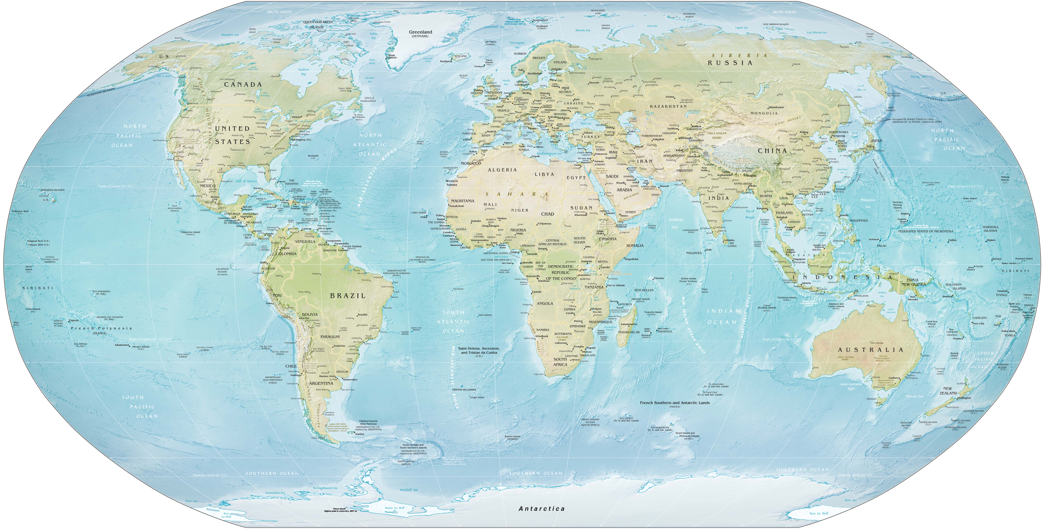
English: Map of the world as of February 2016. Robinson projection, standard parallels 38°N and 38°S. |
||
| Deiziad | |||
| Mammenn | Derivative of Map of the world by the US Gov as of 2016.svg; originally from CIA World Factbook. | ||
| Aozer | US Government, Central Intelligence Agency | ||
| Stummoù all |
|
||
| SVG genesis |
|

|
Aotre-implijout
This work is in the public domain in the United States because it is a work prepared by an officer or employee of the United States Government as part of that person’s official duties under the terms of Title 17, Chapter 1, Section 105 of the US Code.
Note: This only applies to original works of the Federal Government and not to the work of any individual U.S. state, territory, commonwealth, county, municipality, or any other subdivision. This template also does not apply to postage stamp designs published by the United States Postal Service since 1978. (See § 313.6(C)(1) of Compendium of U.S. Copyright Office Practices). It also does not apply to certain US coins; see The US Mint Terms of Use.
|
 | |
| Rummet eo bet ar restr-mañ e-touez ar restroù hep strishadurioù implij anavezet evit ar pezh a sell ouzh ar gwirioù aozer, ha kement-se evit an holl wirioù kar ha stag. | ||
Istor ar restr
Klikañ war un deiziad/eur da welet ar restr evel ma oa da neuze.
| Deiziad/Eur | Munud | Mentoù | Implijer | Notenn | |
|---|---|---|---|---|---|
| red | 28 Gen 2021 da 17:12 | | 3 464 × 1 755 (21,61 Mio) | Ravenpuff | Fix clip |
| 28 Gen 2021 da 16:51 |  | 3 464 × 1 755 (21,61 Mio) | Ravenpuff | Clip out white background from raster image of map | |
| 9 Gou 2019 da 04:19 |  | 3 464 × 1 755 (21,6 Mio) | Kaldari | Fixing label for Rub' al Khali Desert | |
| 8 Gou 2019 da 15:32 |  | 3 464 × 1 755 (21,6 Mio) | Kaldari | Removing random square under Ross Sea label | |
| 8 Gou 2019 da 15:16 |  | 3 464 × 1 755 (21,42 Mio) | Kaldari | User created page with UploadWizard |
Implij ar restr
Implijout a ra ar bajenn da heul ar restr-mañ :
Implij hollek ar restr
Ober a ra ar wikioù da-heul gant ar restr-mañ :
- Implij war ar.wikipedia.org
- Implij war bbc.wikipedia.org
- Implij war bcl.wikipedia.org
- Implij war bn.wikipedia.org
- Implij war bs.wikipedia.org
- Implij war en.wikipedia.org
- Talk:Robinson projection
- Wikipedia:Featured pictures/Diagrams, drawings, and maps/Maps
- Wikipedia:Featured picture candidates/July-2019
- Wikipedia:Featured pictures thumbs/65
- Wikipedia:Featured picture candidates/Map of the world by the US Gov
- User talk:Kaldari/Archive 24
- Wikipedia:Picture of the day/February 2021
- Template:POTD/2021-02-01
- User:Northamerica1000/Topics
- Portal:Geography/Selected picture
- Wikipedia:Main Page history/2021 February 1
- Wikipedia:Main Page history/2021 February 1b
- User:Kuevans/Introduction to Comparative Politics
- Implij war es.wikipedia.org
- Implij war ff.wikipedia.org
- Implij war ha.wikipedia.org
- Implij war hi.wikipedia.org
- Implij war hi.wikibooks.org
- Implij war hy.wikipedia.org
- Implij war id.wiktionary.org
- Implij war incubator.wikimedia.org
- Implij war mk.wikipedia.org
- Implij war ms.wikipedia.org
- Implij war ps.wikipedia.org
- Implij war si.wikipedia.org
- Implij war vec.wikipedia.org
- Implij war za.wikipedia.org
- Implij war zh.wikipedia.org