
Restr:Map Land of Israel.jpg
Restr orin (571 × 800 piksel, ment ar restr : 117 Kio, seurt MIME : image/jpeg)
![]()
| Tennet eo ar restr-mañ eus Wikimedia Commons ha gallout a ra bezañ implijet evit raktresoù all. Diskouezet eo deskrivadur he fajenn zeskrivañ amañ dindan. |
Diverradur
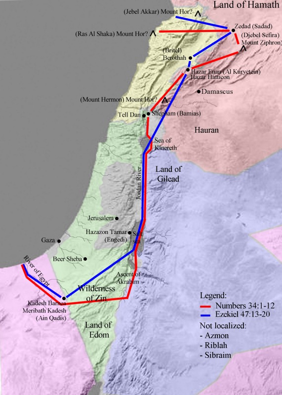
| Deskrivadur | Map of the Land of Israel as defined in Numbers 34 and Ezekiel 47 |
| Deiziad | |
| Mammenn | Labour an-unan |
| Aozer | Emmanuelm |
Sources
Numbers 34:1-12 (KJV) 1 And the LORD spake unto Moses, saying, 2Command the children of Israel, and say unto them, When ye come into the land of Canaan; (this is the land that shall fall unto you for an inheritance, even the land of Canaan with the coasts thereof:) 3Then your south quarter shall be from the wilderness of Zin along by the coast of Edom, and your south border shall be the outmost coast of the salt sea eastward: 4And your border shall turn from the south to the ascent of Akrabbim, and pass on to Zin: and the going forth thereof shall be from the south to Kadeshbarnea, and shall go on to Hazaraddar, and pass on to Azmon: 5And the border shall fetch a compass from Azmon unto the river of Egypt, and the goings out of it shall be at the sea. 6And as for the western border, ye shall even have the great sea for a border: this shall be your west border. 7And this shall be your north border: from the great sea ye shall point out for you mount Hor: 8From mount Hor ye shall point out your border unto the entrance of Hamath; and the goings forth of the border shall be to Zedad: 9And the border shall go on to Ziphron, and the goings out of it shall be at Hazarenan: this shall be your north border. 10And ye shall point out your east border from Hazarenan to Shepham: 11And the coast shall go down from Shepham to Riblah, on the east side of Ain; and the border shall descend, and shall reach unto the side of the sea of Chinnereth eastward: 12And the border shall go down to Jordan, and the goings out of it shall be at the salt sea: this shall be your land with the coasts thereof round about.
Ezekiel 47:13-20 13 Thus saith the Lord GOD; This shall be the border, whereby ye shall inherit the land according to the twelve tribes of Israel: Joseph shall have two portions. 14And ye shall inherit it, one as well as another: concerning the which I lifted up mine hand to give it unto your fathers: and this land shall fall unto you for inheritance. 15And this shall be the border of the land toward the north side, from the great sea, the way of Hethlon, as men go to Zedad; 16Hamath, Berothah, Sibraim, which is between the border of Damascus and the border of Hamath; Hazarhatticon, which is by the coast of Hauran. 17And the border from the sea shall be Hazarenan, the border of Damascus, and the north northward, and the border of Hamath. And this is the north side. 18And the east side ye shall measure from Hauran, and from Damascus, and from Gilead, and from the land of Israel by Jordan, from the border unto the east sea. And this is the east side. 19And the south side southward, from Tamar even to the waters of strife in Kadesh, the river to the great sea. And this is the south side southward. 20 The west side also shall be the great sea from the border, till a man come over against Hamath. This is the west side.
Interpretations
My first reference was The International Standard Bible Encyclopedia Online. I also used the Explanation of the Boundaries of Palestine According to Numbers 34:3, &c. from Jewish-American History on the Web. I also made much use of Bible Wiki archive copy at the Wayback Machine and, of course, Google and Google Images.
According to a bunch of rabbis, the map is all wrong. They do not explain why or offer another map. They probably prefer the first definition of the Promised Land, found in Genesis 15, which defines a much larger territory. I attempted to draw it in another map, Image:Greater Israel map.jpg. Since no one criticized this second map, I understand it is the one they like.
After drawing this map, I found another map in a very detailed article archive copy at the Wayback Machine from The Jewish Theological Seminary. As far as I can see, the differences are minor. After being criticized by rabbis, I am glad to find other rabbis that agree with me. I'll let them argue with each other.
Inevitably, the interpretation of these old texts is controversial. The most important controversy is the location of the Brook of Egypt. Earlier Jewish authors understand it as the Nile, more precisely the Pelusian branch of the Nile Delta. Later authors identify it as the Wadi El-Arish, a small seasonal brook in the Sinai (Kadesh Barnea and Azmon are in the valley of one of its branches [1]). On the current map, I drew the latter as the Southern border.
![[1]](http://www.preceptaustin.org/030.jpg)
Another controversy is the location of the Northern Mount Hor. Some would like to place in at Mount Hermon, in the Golan height between Syria and Lebanon. This would greatly change the tracing of the Northern border defined in Numbers, which would no longer overlap with the Northern border defined in Ezekiel.
- To address the ambiguity in the location of Mount Hor, I updated this map to show three possible locations. The red line still goes to Ras al Shaka, which is near Mount Akkar. However, locating it a Mount Hermon would give a very bizarre map, with the red line crossing itself. Emmanuelm (talk) 12:40, 1 October 2008 (UTC)
Personal comment
This is a scaled down JPEG copy of a 1433 x 2009 pixel Corel PhotoPaint file.
The exact locations of many of these sites is lost forever. This map is therefore the result of speculations by many experts (not me). If you feel strongly about some aspect of it, contact me with references. To preserve the quality of the image, future edits should be done on the original file.
Aotre-implijout
- Gallout a rit :
- eskemm – eilañ, skignañ ha treuzkas an oberenn-mañ
- kemmañ – azasaat an oberenn-mañ
- diouzh ma heuilhit kement-mañ :
- deroadenn – Rankout a rit reiñ an titouroù perc'henniezh rekis diwar-benn an aozer, pourchas ul liamm war-zu an aotre-implijout ha merkañ hag-eñ ez eus bet graet kemmoù. Gallout a rit en ober en un doare reizh met hep lakaat da grediñ ez oc'h bet aprouet gantañ pe ez eo aprouet gantañ implij an oberenn-mañ.
,
Istor ar restr
Klikañ war un deiziad/eur da welet ar restr evel ma oa da neuze.
| Deiziad/Eur | Munud | Mentoù | Implijer | Notenn | |
|---|---|---|---|---|---|
| red | 1 Her 2008 da 12:33 | | 571 × 800 (117 Kio) | Emmanuelm | {{Information |Description=Map of the Land of Israel as defined in Numbers 34 and Ezekiel 47. Version 2 |Source= self-made |Date= October 1st 2008 |Author= Emmanuelm |Permission= see below |other_versions= }} Category:Maps of ancient Israel |
| 21 Her 2007 da 18:57 |  | 571 × 800 (110 Kio) | Emmanuelm | {{Information |Description= Map of the Land of Israel as defined in Numbers 34 and Ezekiel 47 |Source=self-made |Date=October 21 2007 |Author= Emmanuelm }} |
Implij ar restr
Implijout a ra ar bajenn da heul ar restr-mañ :
Implij hollek ar restr
Ober a ra ar wikioù da-heul gant ar restr-mañ :
- Implij war af.wikipedia.org
- Implij war ang.wikipedia.org
- Implij war ar.wikipedia.org
- Implij war az.wikipedia.org
- Implij war bn.wikipedia.org
- Implij war ca.wikipedia.org
- Implij war ckb.wikipedia.org
- Implij war cs.wikipedia.org
- Implij war da.wikipedia.org
- Implij war de.wikipedia.org
- Implij war en.wikipedia.org
- History of Israel
- Israeli Declaration of Independence
- Israeli settlement
- Zionism
- Israeli–Palestinian conflict
- Canaan
- Law of Return
- Promised Land
- Kadesh (biblical)
- Masei
- Demographic history of Palestine (region)
- Israeli-occupied territories
- Portal:Judaism/Featured picture
- Israel
- Sadad, Syria
- User:Emmanuelm/Images I uploaded
- Chronology of Aliyah in modern times
- History of Palestine
- Timeline of the name Palestine
- Template:Zionism and the Land of Israel
- Land of Israel
- Portal:Judaism/Featured picture/11
- Ezekiel 47
- User:প্রলয়স্রোত/sandbox
- User:Falcaorib
- List of journalists killed during the Israeli–Palestinian conflict
- User:Aidanoakes/sandbox
- User:Aidanoakes/sandbox/sandbox
- User:Aidanoakes/sandbox/sandboxx
- Israeli war crimes
- Hamas war crimes
- Implij war es.wikipedia.org
- Implij war fi.wikipedia.org
- Implij war fr.wikipedia.org
- Implij war gl.wikipedia.org
Gwelet muioc'h eus implij hollek ar restr-mañ.