Restr:Klödenplan-Berlin-Kölln-Anfang-13tes-Jahrhundert.jpg

N’eus ket eus endalc’had ar bajenn e yezhoù all.
Eus Wikipedia

Restr orin(908 × 907 piksel, ment ar restr : 334 Kio, seurt MIME : image/jpeg)

Restr Wikimedia Commons

Tennet eo ar restr-mañ eus Wikimedia Commons ha gallout a ra bezañ implijet evit raktresoù all. Diskouezet eo deskrivadur he fajenn zeskrivañ amañ dindan.

Object location

Object location52° 30′ 54,98″ N, 13° 24′ 23,64″ R Kartographer map based on OpenStreetMap.Gwelet al lec’h-se e : OpenStreetMapinfo

Diverradur

Deskrivadur
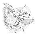
Deutsch: Karl Friedrich Klöden, Karte Berlin und Cölln um 1230 (Wiederherstellungsversuch). Der Fluss Zpriawa ist die heutige Spree. Rechts befindet sich das Spreebecken mit gestautem Wasser. Der Mühlendamm heißt noch Overfahrt. Links der tote Seitenarm der Spree, der spätere Kupfergraben.
English: Karl Friedrich Klöden, map Berlin and Cölln c. 1230
Deiziad ≈ 1840
Mammenn Richard George (Hrsg.) Hie gut Brandenburg alleweg!, Verlag von W. Pauli's Nachfahren, Berlin 1900, page 101
Aozer Karl Friedrich Klöden (1786-1856)
Aotre
(Adimplij ar restr-mañ)
Public domain

This work is in the public domain in its country of origin and other countries and areas where the copyright term is the author's life plus 70 years or fewer.


You must also include a United States public domain tag to indicate why this work is in the public domain in the United States. Note that a few countries have copyright terms longer than 70 years: Mexico has 100 years, Jamaica has 95 years, Colombia has 80 years, and Guatemala and Samoa have 75 years. This image may not be in the public domain in these countries, which moreover do not implement the rule of the shorter term. Honduras has a general copyright term of 75 years, but it does implement the rule of the shorter term. Copyright may extend on works created by French who died for France in World War II (more information), Russians who served in the Eastern Front of World War II (known as the Great Patriotic War in Russia) and posthumously rehabilitated victims of Soviet repressions (more information).

Georeferencing Georeference the map in Wikimaps Warper If inappropriate please set warp_status = skip to hide.

Captions

Add a one-line explanation of what this file represents

Items portrayed in this file

diskouez a ra

52°30'54.976"N, 13°24'23.638"E

Istor ar restr

Klikañ war un deiziad/eur da welet ar restr evel ma oa da neuze.

Deiziad/EurMunudMentoùImplijerNotenn
red15 Kzu 2014 da 16:21Munud eus stumm an 15 Kzu 2014 da 16:21908 × 907 (334 Kio)Messerjokke79more contrast
10 Kzu 2004 da 00:56Munud eus stumm an 10 Kzu 2004 da 00:56908 × 907 (175 Kio)Aquino~commonswikiK.F. Klöden: Berlin und Kölln im Anfang des 13. Jahrhunderts {{PD-Old}}

Implijout a ra ar bajenn da heul ar restr-mañ :

Implij hollek ar restr

Ober a ra ar wikioù da-heul gant ar restr-mañ :