
Restr:Guanahani indicated in Juan de la Cosa map from 1500.png
N'haller ket gwellaat ar pizhder.
Guanahani_indicated_in_Juan_de_la_Cosa_map_from_1500.png (150 × 144 piksel, ment ar restr : 38 Kio, seurt MIME : image/png)
![]()
| Tennet eo ar restr-mañ eus Wikimedia Commons ha gallout a ra bezañ implijet evit raktresoù all. Diskouezet eo deskrivadur he fajenn zeskrivañ amañ dindan. |
Diverradur
| Deskrivadur |
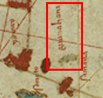
Español: Guanahani (San Salvador - first string of islets discovered by Columbus in 1492) - Label and islets marked within the red box |
| Deiziad | |
| Mammenn | Juan de la Cosa map from 1500 |
| Aozer | Juan de la Cosa |
Part of the full Juan de la Cosa map: http://en.wikipedia.org/wiki/Map_of_Juan_de_la_Cosa
Aotre-implijout
|
This work is in the public domain in its country of origin and other countries and areas where the copyright term is the author's life plus 100 years or fewer. | |
| Rummet eo bet ar restr-mañ e-touez ar restroù hep strishadurioù implij anavezet evit ar pezh a sell ouzh ar gwirioù aozer, ha kement-se evit an holl wirioù kar ha stag. | |
Istor ar restr
Klikañ war un deiziad/eur da welet ar restr evel ma oa da neuze.
| Deiziad/Eur | Munud | Mentoù | Implijer | Notenn | |
|---|---|---|---|---|---|
| red | 17 Ebr 2013 da 00:15 | | 150 × 144 (38 Kio) | MarkMolander | User created page with UploadWizard |
Implij ar restr
Implijout a ra ar bajenn da heul ar restr-mañ :
Implij hollek ar restr
Ober a ra ar wikioù da-heul gant ar restr-mañ :
- Implij war en.wikipedia.org