
Restr:France departments 1791 (1).jpg

Restr orin (1 635 × 1 303 piksel, ment ar restr : 895 Kio, seurt MIME : image/jpeg)
![]()
| Tennet eo ar restr-mañ eus Wikimedia Commons ha gallout a ra bezañ implijet evit raktresoù all. Diskouezet eo deskrivadur he fajenn zeskrivañ amañ dindan. |
.jpg)
| Deskrivadur |
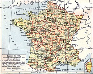
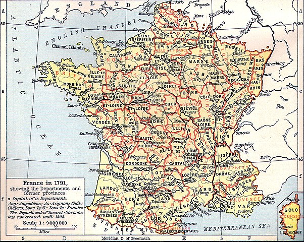
Français : Carte de la France en 1791 (départements et anciennes provinces - en rouge) in The Historical Atlas by William R. Shepherd, 1926
Lëtzebuergesch: Departementer vu Frankräich am Joer 1791. |
| Deiziad | 11 Meurzh 2006 (original upload date) |
| Mammenn | Transferred from fr.wikipedia to Commons by Korrigan using CommonsHelper. |
| Aozer | The original uploader was Tournachon at galleg Wikipedia. |
| Stummoù all | Derivative works of this file: Départements et provinces de France.png |
Aotre-implijout
|
This work is in the public domain in its country of origin and other countries and areas where the copyright term is the author's life plus 70 years or fewer.
| |
| Rummet eo bet ar restr-mañ e-touez ar restroù hep strishadurioù implij anavezet evit ar pezh a sell ouzh ar gwirioù aozer, ha kement-se evit an holl wirioù kar ha stag. | |
Marilh orin ar pellgargadurioù
- 2006-03-11 14:51 Tournachon 741×599×??? (225908 bytes)
Istor ar restr
Klikañ war un deiziad/eur da welet ar restr evel ma oa da neuze.
| Deiziad/Eur | Munud | Mentoù | Implijer | Notenn | |
|---|---|---|---|---|---|
| red | 22 Gou 2022 da 14:31 | | 1 635 × 1 303 (895 Kio) | Hohum | Clearer version |
| 24 Gen 2012 da 22:43 |  | 741 × 599 (634 Kio) | MarcusBritish | Lower red tint. | |
| 24 Gen 2012 da 22:41 |  | 741 × 599 (622 Kio) | MarcusBritish | Improve tones/colour/contrast. | |
| 22 Gwe 2008 da 08:46 |  | 741 × 599 (221 Kio) | File Upload Bot (Magnus Manske) | {{BotMoveToCommons|fr.wikipedia}} {{Information |Description={{fr|Carte de la France en 1791 (départements et anciennes provinces - en rouge) in The Historical Atlas by William R. Shepherd, 1926 == Licence == [[:fr:Catégorie:Cartes Histoire de Fr |
Implij ar restr
Implijout a ra ar bajenn da heul ar restr-mañ :
Implij hollek ar restr
Ober a ra ar wikioù da-heul gant ar restr-mañ :
- Implij war als.wikipedia.org
- Implij war de.wikipedia.org
- Implij war el.wikipedia.org
- Implij war eo.wikipedia.org
- Implij war es.wikipedia.org
- Implij war eu.wikipedia.org
- Implij war fi.wikipedia.org
- Implij war fr.wikipedia.org
- Implij war hu.wikipedia.org
- Implij war lb.wikipedia.org
- Implij war lv.wikipedia.org
- Implij war mt.wikipedia.org
- Implij war nn.wikipedia.org
- Implij war oc.wikipedia.org
- Implij war pl.wikipedia.org
.jpg)