
Restr:Fangataufa.JPG

Ment ar rakweled-mañ : 600 × 600 piksel. pizhderioù all : 240 × 240 piksel | 480 × 480 piksel | 768 × 768 piksel | 1 024 × 1 024 piksel | 2 000 × 2 000 piksel.
Restr orin (2 000 × 2 000 piksel, ment ar restr : 402 Kio, seurt MIME : image/jpeg)
![]()
| Tennet eo ar restr-mañ eus Wikimedia Commons ha gallout a ra bezañ implijet evit raktresoù all. Diskouezet eo deskrivadur he fajenn zeskrivañ amañ dindan. |
Diverradur
| Deskrivadur |
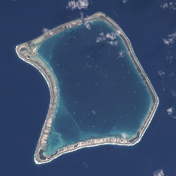
English: NASA Astronaut Image of Fangataufa Atoll (Tuamotu Archipelago, French Polynesia) in the Pacific Ocean
Русский: Космический снимок НАСА атолла Фангатауфа (архипелаг Туамоту, Французская Полинезия) в Тихом океане |
| Deiziad | |
| Mammenn | http://nix.larc.nasa.gov/info;jsessionid=1ci2vn53647eg?id=ISS002-E-7354&orgid=3 |
| Aozer | NASA Johnson Space Center - Earth Sciences and Image Analysis |
| Lec’h luc’hskeudennerez | | Gwelet al lec’h-se e : OpenStreetMap |
|---|
This image or video was catalogued by Johnson Space Center of the United States National Aeronautics and Space Administration (NASA) under Photo ID: ISS002-E-7354. This tag does not indicate the copyright status of the attached work. A normal copyright tag is still required. See Commons:Licensing. Other languages:
|
Aotre-implijout
This file is in the public domain in the United States because it was created by the Image Science & Analysis Laboratory, of the NASA Johnson Space Center. NASA copyright policy states that "NASA material is not protected by copyright unless noted". (NASA media use guidelines or Conditions of Use of Astronaut Photographs).
Photo source: ISS002-E-7354.
|

|
This image has been assessed under the valued image criteria and is considered the most valued image on Commons within the scope: Fangataufa atoll, French Polynesia - satellite view. You can see its nomination here. |
Istor ar restr
Klikañ war un deiziad/eur da welet ar restr evel ma oa da neuze.
| Deiziad/Eur | Munud | Mentoù | Implijer | Notenn | |
|---|---|---|---|---|---|
| red | 29 Mez 2017 da 19:06 | | 2 000 × 2 000 (402 Kio) | Szczureq | full resolution |
| 11 Ebr 2008 da 15:26 |  | 418 × 433 (53 Kio) | Vriullop | cropped and rotated with north on top | |
| 15 Her 2007 da 18:35 |  | 640 × 437 (49 Kio) | Переход Артур | {{Information |Description=TUAMOTU ARCHIPELAGO/FANGATAUFA ATOLL |Source= |Date=06.15.2001 |Author=NASA Johnson Space Center - Earth Sciences and Image Analysis |Permission= |other_versions= }} Category:Tuamotu |
Implij ar restr
Implijout a ra ar bajenn da heul ar restr-mañ :
Implij hollek ar restr
Ober a ra ar wikioù da-heul gant ar restr-mañ :
- Implij war ast.wikipedia.org
- Implij war bg.wikipedia.org
- Implij war ca.wikipedia.org
- Implij war ceb.wikipedia.org
- Implij war cs.wikipedia.org
- Implij war de.wikipedia.org
- Implij war en.wikipedia.org
- Implij war es.wikipedia.org
- Implij war eu.wikipedia.org
- Implij war fi.wikipedia.org
- Implij war frr.wikipedia.org
- Implij war fr.wikipedia.org
- Implij war gl.wikipedia.org
- Implij war id.wikipedia.org
- Implij war it.wikipedia.org
- Implij war ja.wikipedia.org
- Implij war ko.wikipedia.org
- Implij war lt.wikipedia.org
- Implij war nl.wikipedia.org
- Implij war no.wikipedia.org
- Implij war pap.wikipedia.org
- Implij war pl.wikipedia.org
- Implij war pl.wiktionary.org
- Implij war pt.wikipedia.org
- Implij war ru.wikipedia.org
- Implij war simple.wikipedia.org
- Implij war sk.wikipedia.org
- Implij war sv.wikipedia.org
- Implij war sv.wiktionary.org
- Implij war sw.wikipedia.org
- Implij war uk.wikipedia.org
- Implij war www.wikidata.org
- Implij war zh.wikipedia.org