
Restr:DesertStormMap v2.svg

Ment rakwel PNG ar restr SVG : 800 × 563 piksel. pizhderioù all : 320 × 225 piksel | 640 × 451 piksel | 1 024 × 721 piksel | 1 280 × 901 piksel | 2 560 × 1 802 piksel | 1 500 × 1 056 piksel.
Restr orin (restr SVG file, pizhder 1 500 × 1 056 piksel, ment ar restr : 3,13 Mio)
![]()
| Tennet eo ar restr-mañ eus Wikimedia Commons ha gallout a ra bezañ implijet evit raktresoù all. Diskouezet eo deskrivadur he fajenn zeskrivañ amañ dindan. |
|

Diverradur
This W3C-unspecified vector image was created with Inkscape .
| Titl |
Operation Desert Storm |
||||
| Deskrivadur |
العربية: عملية عاصفة الصحراء، ضمن حرب الخليج الثانية، 24-28 شباط/ فبراير 1991.
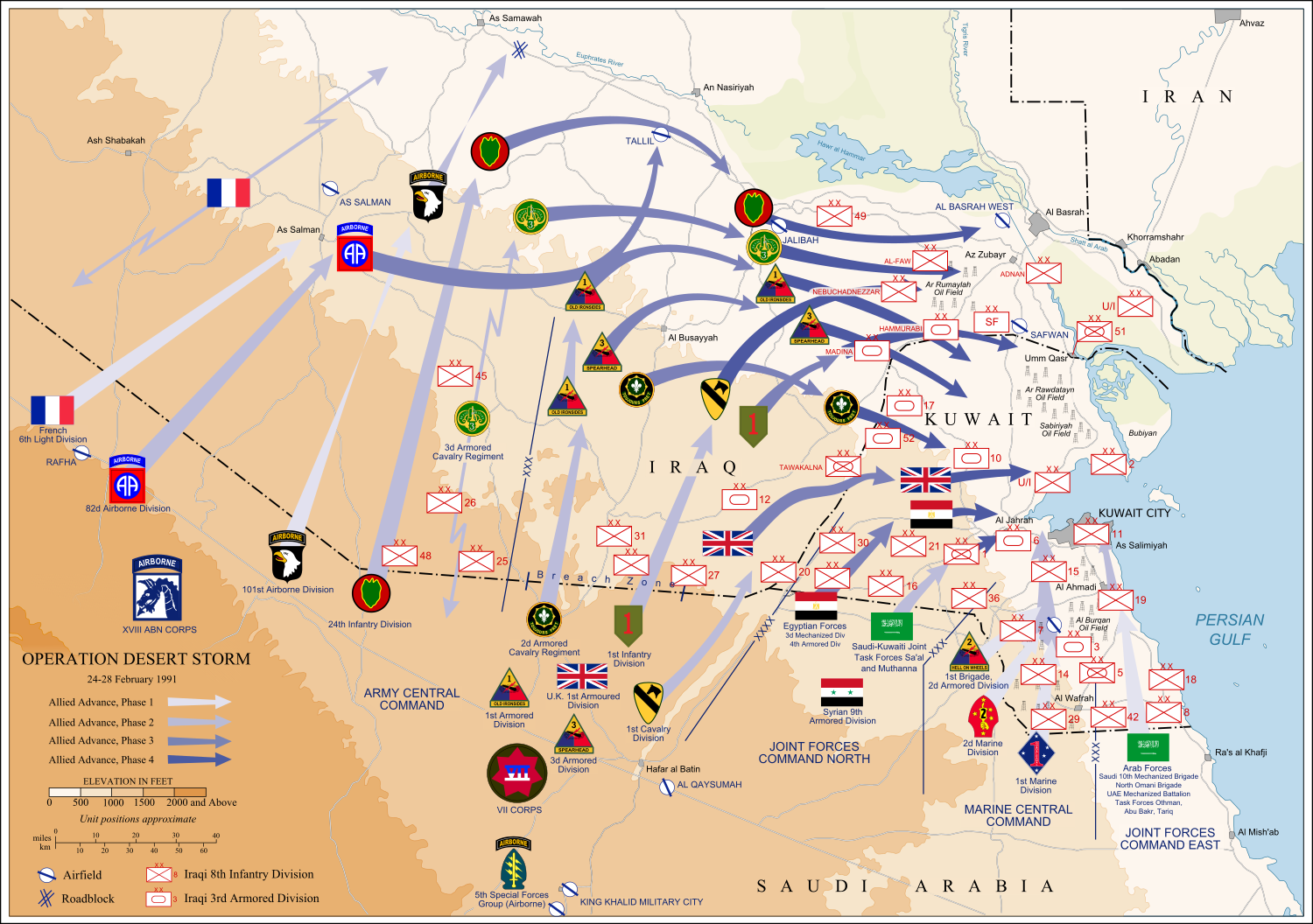
English: Map of ground operations of Operation Desert Storm starting invasion February 24-28th 1991. Shows allied and Iraqi forces. Special arrows indicate the American 101st Airborne division moved by air and where the French 6st light division and American 3rd Armored Cavalry Regiment provided security.
Français : Carte montrant les opérations terrestres menées lors de l'opération Tempête du désert entre le 24 et le 28 février 1991 : les positions tenues par les armées irakienne et alliées, et les mouvements de cette dernière. Des flèches particulières indiquent les manœuvres héliportées pratiquées par la 101e division aéroportée, ainsi que les zones sécurisées par la 6e brigade légère blindée française et par le 3e régiment blindé de cavalerie américain. |
||||
| Deiziad | (UTC) | ||||
| Mammenn | self-vectored from Image:Operation Desert Storm.jpg from this site and this site. | ||||
| Krouet gant |
US Army |
||||
| Geotemporal data | |||||
| Date depicted | |||||
| Map location | Iraq/Kuwait border | ||||
| OpenStreetMap zoom level | 9 | ||||
| Bounding box |
|
||||
| Georeferencing | |||||
| Bibliographic data | |||||
| Yezh | eng | ||||
| Archival data | |||||
| Mod | Inkscape SVG | ||||
| Stummoù all |
 |
||||

Aotre-implijout
This file is a work of a U.S. Army soldier or employee, taken or made as part of that person's official duties. As a work of the U.S. federal government, it is in the public domain in the United States.
|
 |
Evel perc'henn eus ar gwirioù oberour, e embannan an oberenn-mañ dindan an aotreoù-implijout da-heul :

|
Aotre zo da eilañ, skignañ ha kemmañ an teul-mañ dindan termennoù ar GNU Free Documentation License, stumm 1.2 pe stummoù nevesoc'h embannet gant ar Free Software Foundation; hep rannoù digemm, na testenn pajenn golo 1 pe golo 4 ebet. Kavet e vo un eilskrid eus an aotre-implijout er rannbennad anvet GNU Free Documentation License. |
This file is licensed under the Creative Commons Attribution-Share Alike 4.0 International, 3.0 Unported, 2.5 Generic, 2.0 Generic and 1.0 Generic license.
- Gallout a rit :
- eskemm – eilañ, skignañ ha treuzkas an oberenn-mañ
- kemmañ – azasaat an oberenn-mañ
- diouzh ma heuilhit kement-mañ :
- deroadenn – Rankout a rit reiñ an titouroù perc'henniezh rekis diwar-benn an aozer, pourchas ul liamm war-zu an aotre-implijout ha merkañ hag-eñ ez eus bet graet kemmoù. Gallout a rit en ober en un doare reizh met hep lakaat da grediñ ez oc'h bet aprouet gantañ pe ez eo aprouet gantañ implij an oberenn-mañ.
- eskemmañ rik-ha-rik – Ma tegasit kemmoù, ma treuzfurmit pe ma savit un dra bennak diwar an oberenn-mañ e rankit skignañ an oberenn krouet ganeoc'h dindan an hevelep aotre-implijout pe un aotre-implijout kar-tost d'an hini orin.
Gallout a rit diuzañ an aotre-implijout a fell deoc'h.
Istor ar restr
Klikañ war un deiziad/eur da welet ar restr evel ma oa da neuze.
| Deiziad/Eur | Munud | Mentoù | Implijer | Notenn | |
|---|---|---|---|---|---|
| red | 9 Mez 2012 da 13:14 | | 1 500 × 1 056 (3,13 Mio) | Coolland | uploaded with x-external-editor |
| 6 C'hwe 2008 da 04:31 |  | 1 500 × 1 056 (3,13 Mio) | Jeff Dahl | flags/label edits | |
| 4 C'hwe 2008 da 21:00 |  | 1 500 × 1 056 (2,89 Mio) | Jeff Dahl | == Summary == {{Inkscape}} {{Information |Description=Map of ground operations of Operation Desert Storm from February 24-28th 1991. Shows allied and Iraqi forces. |Source=self-made, vectored from Image:Operation Desert Storm.jpg from [http://www.his |
Implij ar restr
Implijout a ra ar bajenn da heul ar restr-mañ :
Implij hollek ar restr
Ober a ra ar wikioù da-heul gant ar restr-mañ :
- Implij war an.wikipedia.org
- Implij war ar.wikipedia.org
- Implij war bg.wikipedia.org
- Implij war ca.wikipedia.org
- Implij war cs.wikipedia.org
- Implij war de.wikipedia.org
- Implij war el.wikipedia.org
- Implij war en.wikipedia.org
- French Foreign Legion
- Kuwait Armed Forces
- Armed Forces of Saudi Arabia
- 101st Airborne Division
- 82nd Airborne Division
- Gulf War
- 1st Cavalry Division (United States)
- 3rd Armored Division (United States)
- VII Corps (United States)
- 24th Infantry Division (United States)
- Norman Schwarzkopf Jr.
- 1st (United Kingdom) Division
- Air assault
- Battle of Khafji
- Royal Green Jackets (Rifles) Museum
- Iraqi invasion of Kuwait
- List of conflicts in Asia
- Opération Daguet
- Portal:Maps/Selected picture
- 1st Foreign Cavalry Regiment
- Wikipedia:WikiProject Iraq
- Wikipedia:Featured pictures thumbs/10
- Wikipedia:Featured picture candidates/February-2008
- Wikipedia:Featured picture candidates/Operation Desert Storm
- Wikipedia:Wikipedia Signpost/2008-02-18/Features and admins
- User talk:Jeff Dahl/Archive 3
- 82nd Sustainment Brigade
- Wikipedia:Featured pictures/Diagrams, drawings, and maps/Maps
- Wikipedia:WikiProject United States Government
- Wikipedia:Picture of the day/July 2008
- Template:POTD/2008-07-27
- User talk:Jeff Dahl/Archive 4
- Wikipedia:Wikipedia Signpost/2008-02-18/SPV
- Portal:Maps/Selected picture/38
- Wikipedia:WikiProject Military history/Showcase
- Wikipedia:WikiProject Military history/Showcase/FP
- 1st Brigade, 24th Infantry Division (United States)
- 2nd Brigade, 24th Infantry Division (United States)
Gwelet muioc'h eus implij hollek ar restr-mañ.