
Restr:Bastille in Medieval Paris Map..png
N'haller ket gwellaat ar pizhder.
Bastille_in_Medieval_Paris_Map..png (422 × 406 piksel, ment ar restr : 98 Kio, seurt MIME : image/png)
![]()
| Tennet eo ar restr-mañ eus Wikimedia Commons ha gallout a ra bezañ implijet evit raktresoù all. Diskouezet eo deskrivadur he fajenn zeskrivañ amañ dindan. |
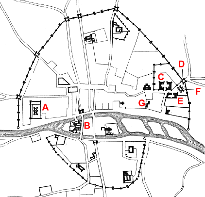
| Deskrivadur | Map of Paris in 14th century |
| Deiziad | (UTC) |
| Mammenn | |
| Aozer |
|
| This is a retouched picture, which means that it has been digitally altered from its original version. Modifications: trimmed and labelled. The original can be viewed here: Plan.Paris.XIVe.siecle.2.png:
|
This work is in the public domain in the United States because it was published (or registered with the U.S. Copyright Office) before January 1, 1929.
|
|
This work is in the public domain in its country of origin and other countries and areas where the copyright term is the author's life plus 100 years or fewer. This work is in the public domain in the United States because it was published (or registered with the U.S. Copyright Office) before January 1, 1929. | |
| Rummet eo bet ar restr-mañ e-touez ar restroù hep strishadurioù implij anavezet evit ar pezh a sell ouzh ar gwirioù aozer, ha kement-se evit an holl wirioù kar ha stag. | |
Marilh orin ar pellgargadurioù
This image is a derivative work of the following images:
- File:Plan.Paris.XIVe.siecle.2.png licensed with Cc-pd-mark-footer, PD-1923, PD-old-100, Viollet-le-Duc
- 2005-08-30T17:26:39Z Buzz 558x712 (53855 Bytes) Plan de Paris au XIVe siècle. Élargissment des fortifications, pendant l'emprisonnement du roi Jean. Issu du Dictionnaire raisonné de l'architecture française du XIe au XVIe siècle, par Eugène Viollet-Le-Duc, 1856. {{. A – the Louvre; B – Palais de Roi; C – Hôtel des Tournelles; D – Porte Saint-Antoine; E – Hôtel St Paul; F – the Bastille.
Uploaded with derivativeFX
Istor ar restr
Klikañ war un deiziad/eur da welet ar restr evel ma oa da neuze.
| Deiziad/Eur | Munud | Mentoù | Implijer | Notenn | |
|---|---|---|---|---|---|
| red | 23 Eos 2011 da 19:29 | | 422 × 406 (98 Kio) | Hchc2009 | Labelling in red |
| 15 Eos 2011 da 16:06 |  | 422 × 406 (98 Kio) | Hchc2009 | {{Information |Description=Map of Paris in 14th century |Source=*File:Plan.Paris.XIVe.siecle.2.png |Date=2011-08-15 16:03 (UTC) |Author=*File:Plan.Paris.XIVe.siecle.2.png: Viiolet le Duc *derivative work: ~~~ |Permission= |other_versions= }} |
Implij ar restr
Implijout a ra ar bajenn da heul ar restr-mañ :
Implij hollek ar restr
Ober a ra ar wikioù da-heul gant ar restr-mañ :