
Restr:1696 Genroku 9 (early Edo) Japanese Map of Kyoto, Japan - Geographicus - Kyoto-genroku9-1696.jpg

Ment ar rakweled-mañ : 437 × 599 piksel. pizhderioù all : 175 × 240 piksel | 350 × 480 piksel | 560 × 768 piksel | 747 × 1 024 piksel | 1 494 × 2 048 piksel | 4 478 × 6 139 piksel.
Restr orin (4 478 × 6 139 piksel, ment ar restr : 6,91 Mio, seurt MIME : image/jpeg)
![]()
| Tennet eo ar restr-mañ eus Wikimedia Commons ha gallout a ra bezañ implijet evit raktresoù all. Diskouezet eo deskrivadur he fajenn zeskrivañ amañ dindan. |
_Japanese_Map_of_Kyoto,_Japan_-_Geographicus_-_Kyoto-genroku9-1696.jpg)
| Kyoto. | ||||||
|---|---|---|---|---|---|---|
| Arzour | ||||||
| Titl |
Kyoto. |
|||||
| Deskrivadur |
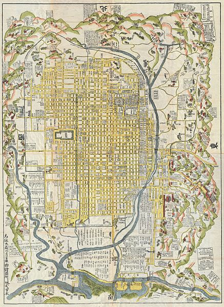
English: A rare 1696 Japanese woodblock map of Kyoto, Japan. Made in the early Edo period during the 9th year of Genroku era. Covers the city of Kyoto and its immediate vicinity. Like most early Japanese maps, this map does not have a firm directional orientation, rather all text radiates out from the center. Labels streets, waterways, mountains and important buildings. Despite 1696 date, it may be a reissue circa 1860, based upon the type of paper used. |
|||||
| Deiziad | 1696 (dated: Genroku 9, early Edo) | |||||
| Mentoù | uhelder: 60 in (152,4 cm); led: 45 in (114,3 cm) | |||||
| Niverenn renabl |
Geographicus link: Kyoto-genroku9-1696 |
|||||
| Mammenn/Luc'hskeudenner |
|
|||||
| Aotre (Adimplij ar restr-mañ) |
|
|||||
Istor ar restr
Klikañ war un deiziad/eur da welet ar restr evel ma oa da neuze.
| Deiziad/Eur | Munud | Mentoù | Implijer | Notenn | |
|---|---|---|---|---|---|
| red | 22 Meu 2011 da 15:25 | | 4 478 × 6 139 (6,91 Mio) | BotMultichillT | {{subst:User:Multichill/Geographicus |link=http://www.geographicus.com/P/AntiqueMap/Kyoto-genroku9-1696 |product_name=1696 Genroku 9 (early Edo) Japanese Map of Kyoto, Japan |map_title=Kyoto. |description=A rare and extraordinary 1696 Japanese woodblock m |
Implij ar restr
Implijout a ra ar bajenn da heul ar restr-mañ :
Implij hollek ar restr
Ober a ra ar wikioù da-heul gant ar restr-mañ :
- Implij war ckb.wikipedia.org
- Implij war de.wikipedia.org
- Implij war en.wikipedia.org
- Implij war es.wikipedia.org
- Implij war fr.wikipedia.org
- Implij war gl.wikipedia.org
- Implij war it.wikipedia.org
- Implij war ja.wikipedia.org
- Implij war ko.wikipedia.org
- Implij war pt.wikipedia.org
- Implij war ru.wikipedia.org
- Implij war simple.wikipedia.org
- Implij war sl.wikipedia.org
- Implij war sr.wikipedia.org
- Implij war sv.wikipedia.org
- Implij war vi.wikipedia.org
- Implij war www.wikidata.org
- Implij war zh.wikipedia.org
_Japanese_Map_of_Kyoto,_Japan_-_Geographicus_-_Kyoto-genroku9-1696.jpg)