
Restr:KangnidoMap.jpg
N'haller ket gwellaat ar pizhder.
KangnidoMap.jpg (600 × 556 piksel, ment ar restr : 81 Kio, seurt MIME : image/jpeg)
![]()
| Tennet eo ar restr-mañ eus Wikimedia Commons ha gallout a ra bezañ implijet evit raktresoù all. Diskouezet eo deskrivadur he fajenn zeskrivañ amañ dindan. |
Diverradur
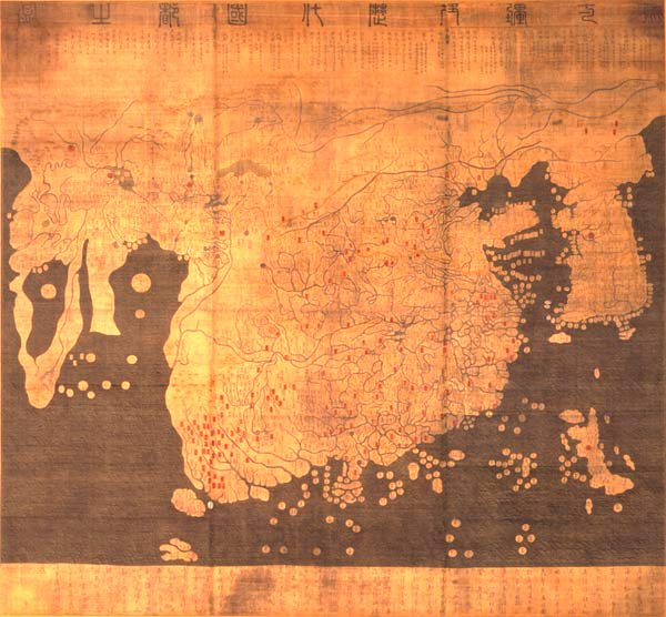
| Titl |
English: Kangnido 한국어: 혼일강리역대국도지도 |
|||||||||
| Deskrivadur |
English: Kangnido map (1402). The later Honkōji version of the map is available here: GeneralMapOfDistancesAndHistoricCapitals.jpg at a higher resolution. 한국어: 혼일강리역대국도지도. |
|||||||||
| Deiziad | ||||||||||
| Mammenn | ... | |||||||||
| Krouet gant |
Kim Sahyung, Lee Moo, Lee Hui |
|||||||||
| Geotemporal data | ||||||||||
| Date depicted | ||||||||||
| Bounding box |
|
|||||||||
| Georeferencing | ||||||||||
| Bibliographic data | ||||||||||
| Yezh | Hanja | |||||||||
Aotre-implijout
|
This is a faithful photographic reproduction of a two-dimensional, public domain work of art. The work of art itself is in the public domain for the following reason:
The official position taken by the Wikimedia Foundation is that "faithful reproductions of two-dimensional public domain works of art are public domain".
This photographic reproduction is therefore also considered to be in the public domain in the United States. In other jurisdictions, re-use of this content may be restricted; see Reuse of PD-Art photographs for details. | ||||
Istor ar restr
Klikañ war un deiziad/eur da welet ar restr evel ma oa da neuze.
| Deiziad/Eur | Munud | Mentoù | Implijer | Notenn | |
|---|---|---|---|---|---|
| red | 22 Meu 2005 da 16:29 | | 600 × 556 (81 Kio) | Julgon~commonswiki | Kangnido map (1402) from en.wikipedia.org |
Implij ar restr
Implijout a ra ar bajenn da heul ar restr-mañ :
Implij hollek ar restr
Ober a ra ar wikioù da-heul gant ar restr-mañ :
- Implij war ar.wikipedia.org
- Implij war azb.wikipedia.org
- Implij war bn.wikipedia.org
- Implij war bs.wikipedia.org
- Implij war ca.wikipedia.org
- Implij war cy.wikipedia.org
- Implij war da.wikipedia.org
- Implij war da.wikibooks.org
- Implij war de.wikipedia.org
- Implij war en.wikipedia.org
- Implij war en.wikiquote.org
- Implij war eo.wikipedia.org
- Implij war es.wikipedia.org
- Implij war et.wikipedia.org
- Implij war eu.wikipedia.org
- Implij war fa.wikipedia.org
- Implij war fa.wikibooks.org
- Implij war fi.wikipedia.org
- Implij war fr.wikipedia.org
- Implij war gl.wikipedia.org
- Implij war hu.wikipedia.org
Gwelet muioc'h eus implij hollek ar restr-mañ.