
Restr:TerreNeuve16e.jpg
TerreNeuve16e.jpg (320 × 514 piksel, ment ar restr : 36 Kio, seurt MIME : image/jpeg)
![]()
| Tennet eo ar restr-mañ eus Wikimedia Commons ha gallout a ra bezañ implijet evit raktresoù all. Diskouezet eo deskrivadur he fajenn zeskrivañ amañ dindan. |
| Deskrivadur |
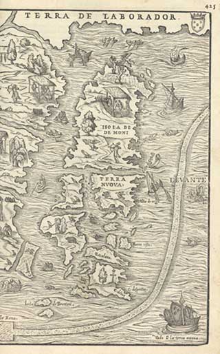
Depiction of Newfoundland and surrounding coasts, by Giacomo Gastaldi, 1565 edition. This is the right half of "La Nuova Francia", a pictorial relief map attributed to Giacomo Gastaldi and first published in 1556, in Giovanni Battista Ramusio, editor, second edition of Terzo volume delle navigationi et viaggi raccolto gia da M. Gio Battista Ramvsio…, Venise, Nella stamperia de Givnti (first 1553 edition of Ramusio's Terzo Volume did not contain map). The original 1556 woodblock was destroyed in a fire and a new block had to be carved for the third 1565 edition, with some slight differences (second block can be identified by weeping willows near New York harbor and Acadian coast)(1556 block version: p.424-25; 1565 block version: p.424-25 ) The Gastaldi map is the earliest printed map showing northeastern North America. It is also the first map to use the term "New France" ("La Nuova Francia") to designate French claims in North America. It also labels the "Terra de Nurumbega" (Abenaki term) on left half, and "Terra de Laborador" (with Portuguese shield) on right half. The Gastaldi map incorporates information from the recent exploration voyages of Giovanni Verrazzano (1524) and Jacques Cartier (1534), as well as earlier explorers like John Cabot (1497) and the Corte-Real brothers (1500-02). The map depicts details of New York harbor ("Angoulesme") and Rhode Island ("Port de Refuge") on the left half, and Cape Breton Island ("C.Breton"), Newfoundland ("Terra Nuova") and Labrador coast ("Terra de Laborador") on right half. It skips over the coastline of New England and Nova Scotia in between. It seems to also show the St. Lawrence River, but does not label it. The right half of the map depicts Newfoundland and the coasts around it. Labels include, from top to bottom, "Terra de Laborador", "Isola de Demoni", "Monte de Trigo", "Terra Nuova", "Bonne viste", "Bacalaos", "C. de Seperanza", "C. de' Ras", "C. Breton", "Isola de Brertoni", "Isola della Rena". It depicts various figures hunting, native canoes, several European fishing boats and fur-traders under canopies. It also depicts birds, turkeys, beavers, bears, codfish, whales and a few winged demons. There is an image of a Portuguese ship at top near Labrador, a wooden cross (possibly left by John Cabot) near Cape Race at bottom, as well as a French ship arriving at bottom right with label "vedo a la terra nuova". |
||||
| Mammenn | Bibliothèque nationale du Canada | ||||
| Aozer | User Catmas on fr.wikipedia | ||||
| Aotre (Adimplij ar restr-mañ) |
|
||||
| Stummoù all |
Originally from fr.wikipedia; description page is (was) here
|
||||
(Uploaded using CommonsHelper or PushForCommons)
Istor ar restr
Klikañ war un deiziad/eur da welet ar restr evel ma oa da neuze.
| Deiziad/Eur | Munud | Mentoù | Implijer | Notenn | |
|---|---|---|---|---|---|
| red | 31 Her 2006 da 19:11 | | 320 × 514 (36 Kio) | Korrigan | {{Information| |Description= Carte du XVIe siècle des régions découvertes par Cabot ''Primo [terzo] volume, & terza editione delle navigationi et viaggi raccolto gia da M. Gio Battista Ramvsio…,'' Giovanni Battista Ramusio, Venise, Nella stamperia d |
Implij ar restr
Implijout a ra ar bajenn da heul ar restr-mañ :
Implij hollek ar restr
Ober a ra ar wikioù da-heul gant ar restr-mañ :
- Implij war ast.wikipedia.org
- Implij war ca.wikipedia.org
- Implij war de.wikipedia.org
- Implij war en.wikipedia.org
- Implij war es.wikipedia.org
- Implij war fr.wikipedia.org
- Implij war oc.wikipedia.org
- Implij war pt.wikipedia.org