
Restr:SpaghettiJunctionGA.jpg

Ment ar rakweled-mañ : 800 × 527 piksel. pizhderioù all : 320 × 211 piksel | 640 × 421 piksel | 992 × 653 piksel.
Restr orin (992 × 653 piksel, ment ar restr : 129 Kio, seurt MIME : image/jpeg)
![]()
| Tennet eo ar restr-mañ eus Wikimedia Commons ha gallout a ra bezañ implijet evit raktresoù all. Diskouezet eo deskrivadur he fajenn zeskrivañ amañ dindan. |
| Lec’h luc’hskeudennerez | | Gwelet al lec’h-se e : OpenStreetMap |
|---|
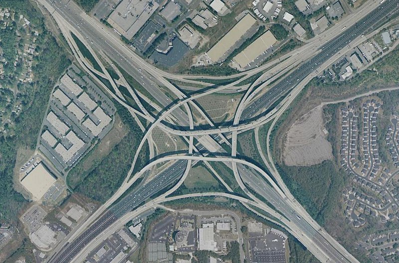
Tom Moreland Interchange, a.k.a. Spaghetti Junction, intersection of Interstate 85 and Interstate 285, just northeast of Atlanta, Georgia, USA. Latitude 33.89221, Longitude -84.25964. Aerial view from USGS "Urban Areas" image database. Composed using NASA World Wind.
This image is in the public domain in the United States because it only contains materials that originally came from the United States Geological Survey, an agency of the United States Department of the Interior. For more information, see the official USGS copyright policy.
|
Istor ar restr
Klikañ war un deiziad/eur da welet ar restr evel ma oa da neuze.
| Deiziad/Eur | Munud | Mentoù | Implijer | Notenn | |
|---|---|---|---|---|---|
| red | 20 Meu 2005 da 09:16 | | 992 × 653 (129 Kio) | Ray Spalding | Spaghetti Junction, GA {{PD-USGov-Interior-USGS}} |
Implij ar restr
Implijout a ra ar bajenn da heul ar restr-mañ :
Implij hollek ar restr
Ober a ra ar wikioù da-heul gant ar restr-mañ :
- Implij war de.wikipedia.org
- Implij war en.wikipedia.org
- Implij war hu.wikipedia.org
- Implij war nl.wikipedia.org
- Implij war sk.wikipedia.org
- Implij war sl.wikipedia.org
- Implij war tr.wikipedia.org
- Implij war zh.wikipedia.org