
Restr:River Nith estuary.jpg

Ment ar rakweled-mañ : 800 × 533 piksel. pizhderioù all : 320 × 213 piksel | 640 × 427 piksel | 1 024 × 683 piksel | 1 280 × 853 piksel | 2 560 × 1 707 piksel | 3 504 × 2 336 piksel.
Restr orin (3 504 × 2 336 piksel, ment ar restr : 8,68 Mio, seurt MIME : image/jpeg)
![]()
| Tennet eo ar restr-mañ eus Wikimedia Commons ha gallout a ra bezañ implijet evit raktresoù all. Diskouezet eo deskrivadur he fajenn zeskrivañ amañ dindan. |
Diverradur
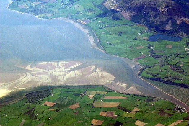
| Deskrivadur | The estuary of the River Nith, Scotland, at low tide; opening into Solway Firth. This is a view of the Nith estuary from the north-east. The group of buildings at bottom right is the village of Glencaple. At bottom left near the wooded area is Caerlaverock Castle. At top right is Loch Kindar and the hill above is called Criffel. Just beyond the top left of photo is the birthplace of John Paul Jones. |
| Deiziad | |
| Mammenn | https://www.flickr.com/photos/52614599@N00/483602946 |
| Aozer | Doc Searls from Santa Barbara, USA |
Aotre-implijout
Emañ ar restr-mañ dindan an aotre-implijout Creative Commons Deroadenn-Kenrannañ 2.0 Hollek
- Gallout a rit :
- eskemm – eilañ, skignañ ha treuzkas an oberenn-mañ
- kemmañ – azasaat an oberenn-mañ
- diouzh ma heuilhit kement-mañ :
- deroadenn – Rankout a rit reiñ an titouroù perc'henniezh rekis diwar-benn an aozer, pourchas ul liamm war-zu an aotre-implijout ha merkañ hag-eñ ez eus bet graet kemmoù. Gallout a rit en ober en un doare reizh met hep lakaat da grediñ ez oc'h bet aprouet gantañ pe ez eo aprouet gantañ implij an oberenn-mañ.
- eskemmañ rik-ha-rik – Ma tegasit kemmoù, ma treuzfurmit pe ma savit un dra bennak diwar an oberenn-mañ e rankit skignañ an oberenn krouet ganeoc'h dindan an hevelep aotre-implijout pe un aotre-implijout kar-tost d'an hini orin.
| This image was originally posted to Flickr by dsearls at https://www.flickr.com/photos/52614599@N00/483602946. It was reviewed on 5 Mae 2007 by FlickreviewR and was confirmed to be licensed under the terms of the cc-by-sa-2.0. |
This is a view of the Nith estuary from the north-east. The group of buildings at bottom right is the village of Glencaple. At bottom left near the wooded area is Caerlaverock Castle. At top right is Loch Kindar and the hill above is called Criffel. Just beyond the top left of photo is the birthplace of John Paul Jones.
Istor ar restr
Klikañ war un deiziad/eur da welet ar restr evel ma oa da neuze.
| Deiziad/Eur | Munud | Mentoù | Implijer | Notenn | |
|---|---|---|---|---|---|
| red | 5 Mae 2007 da 07:14 | | 3 504 × 2 336 (8,68 Mio) | Sandstein | {{Information |Description= The estuary of the River Nith, Scotland, at low tide; opening into Solway Firth. On the near shore, Bowness-on-Solway. On the far, Annan, in Dumfries and Galloway. |Source= http://www.flickr.com/photos/52614599@N00/483602946 |D |
Implij ar restr
Implijout a ra an 2 pajenn da heul ar restr-mañ :
Implij hollek ar restr
Ober a ra ar wikioù da-heul gant ar restr-mañ :
- Implij war ar.wikipedia.org
- Implij war arz.wikipedia.org
- Implij war ast.wikipedia.org
- Implij war bn.wikipedia.org
- Implij war ceb.wikipedia.org
- Implij war cs.wikipedia.org
- Implij war cy.wikipedia.org
- Implij war dag.wikipedia.org
- Implij war de.wikipedia.org
- Implij war en.wikipedia.org
- Implij war en.wikivoyage.org
- Implij war eo.wikipedia.org
- Implij war es.wikipedia.org
- Implij war eu.wikipedia.org
- Implij war fa.wikipedia.org
- Implij war fr.wikipedia.org
- Implij war fy.wikipedia.org
- Implij war ga.wikipedia.org
- Implij war gd.wikipedia.org
- Implij war gv.wikipedia.org
- Implij war hak.wikipedia.org
- Implij war id.wikipedia.org
- Implij war incubator.wikimedia.org
- Implij war it.wikipedia.org
- Implij war it.wikibooks.org
- Implij war it.wikiversity.org
- Implij war ja.wikipedia.org
- Implij war kbd.wikipedia.org
- Implij war lt.wikipedia.org
- Implij war nl.wikipedia.org
- Implij war nn.wikipedia.org
Gwelet muioc'h eus implij hollek ar restr-mañ.