
Restr:Overijssel position.svg

Ment rakwel PNG ar restr SVG : 200 × 236 piksel. pizhderioù all : 203 × 240 piksel | 407 × 480 piksel | 651 × 768 piksel | 868 × 1 024 piksel | 1 736 × 2 048 piksel.
Restr orin (restr SVG file, pizhder 200 × 236 piksel, ment ar restr : 157 Kio)
![]()
| Tennet eo ar restr-mañ eus Wikimedia Commons ha gallout a ra bezañ implijet evit raktresoù all. Diskouezet eo deskrivadur he fajenn zeskrivañ amañ dindan. |
Diverradur
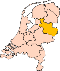
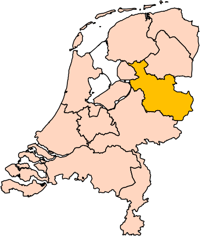
| Deskrivadur | Location of the province of Overijssel in the Netherlands. |
| Mammenn | Labour an-unan |
| Aozer | User:Mtcv |
| Aotre (Adimplij ar restr-mañ) |
Data: attribution required; my work: PD |
| Stummoù all | I attempted to make an svg version of Image:Overijssel-Position.png (with less simplified boundaries) |
Clickable version

Aotre-implijout

|
Reiñ a ra d'an holl, piaouer gwirioù ar restr-mañ, Centraal Bureau voor de Statistiek, an aotre da implijout anezhi evit kement mennad gant ma vo meneget fraezh anv piaouer ar gwirioù. Aotreet eo adskignañ ar restr, sevel oberennoù deveret pe ober un impjij kenwerzhel anezhi, ha kement implij all a c'hall bezañ. |
Deroadenn:
|
| Annotations | This image is annotated: View the annotations at Commons |


Istor ar restr
Klikañ war un deiziad/eur da welet ar restr evel ma oa da neuze.
| Deiziad/Eur | Munud | Mentoù | Implijer | Notenn | |
|---|---|---|---|---|---|
| red | 2 Meu 2019 da 17:20 | | 200 × 236 (157 Kio) | Thayts | update |
| 3 Her 2006 da 00:44 |  | 200 × 236 (158 Kio) | Mtcv | {{Information| |Description=Location of the province of Noord-Holland (North Holland) in the Netherlands. |Source=Own work, based on freely available GIS data |Date=2006-10-03 |Author=User:Mtcv |Permission=Data: attribution required; my work: PD |othe |
Implij ar restr
Pajenn ebet ne implij ar restr-mañ.
Implij hollek ar restr
Ober a ra ar wikioù da-heul gant ar restr-mañ :
- Implij war ar.wikipedia.org
- أفريسل
- زفوله
- ديفينتر
- تفنتة
- قالب:بلديات أوفرآيسل
- هينجيلو
- ألميلو
- هاكسبيرخن
- بورنه (أوفرآيسل)
- أنسخديه
- قالب:مناطق أوفرآيسل
- دالفسن
- صلند
- دينكللاند
- هاردنبيرخ
- هيليندورن
- هوف فان تفنته
- كامبن (هولندا)
- كوب فان أوفرآيسل
- لوسر (هولندا)
- أولدنزال
- أولست- فايه
- أومين (هولندا)
- رالته
- رايسن- هولتن
- ستابهورست
- ستينفايكرلاند
- توبيرخن
- تفنتاراند
- فيردن (هولندا)
- زفارتافاترلاند
- Implij war be-tarask.wikipedia.org
- Implij war cy.wikipedia.org
- Implij war en.wikipedia.org
Gwelet muioc'h eus implij hollek ar restr-mañ.