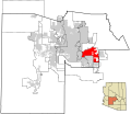
Restr:Maricopa County Incorporated and Planning areas Mesa highlighted.svg

Ment rakwel PNG ar restr SVG : 694 × 599 piksel. pizhderioù all : 278 × 240 piksel | 556 × 480 piksel | 889 × 768 piksel | 1 185 × 1 024 piksel | 2 371 × 2 048 piksel | 940 × 812 piksel.
Restr orin (restr SVG file, pizhder 940 × 812 piksel, ment ar restr : 1,05 Mio)
Istor ar restr
Klikañ war un deiziad/eur da welet ar restr evel ma oa da neuze.
| Deiziad/Eur | Munud | Mentoù | Implijer | Notenn | |
|---|---|---|---|---|---|
| red | 20 Mae 2011 da 06:36 |  | 940 × 812 (1,05 Mio) | Ixnayonthetimmay | Uploading new version |
| 30 Eos 2008 da 04:22 |  | 900 × 800 (413 Kio) | Ixnayonthetimmay | == Summary == {{Information |Description=This map shows the incorporated areas and unincorporated areas in Maricopa County, Arizona. [[:en:Mesa, Arizona|Mesa | |
| 15 Gwe 2007 da 23:58 |  | 900 × 800 (384 Kio) | Ixnayonthetimmay | ||
| 28 Mae 2007 da 10:09 |  | 900 × 780 (329 Kio) | Ixnayonthetimmay | ||
| 22 Mae 2007 da 00:13 |  | 900 × 780 (318 Kio) | Ixnayonthetimmay | ||
| 30 Gen 2007 da 05:17 |  | 904 × 758 (177 Kio) | Ixnayonthetimmay | {{Information |Description=This map shows the incorporated areas in Maricopa County, Arizona, highlighting Mesa in red. It also shows the boundaries for the municip |
Implij ar restr
Implijout a ra ar bajenn da heul ar restr-mañ :
Implij hollek ar restr
Ober a ra ar wikioù da-heul gant ar restr-mañ :
- Implij war bn.wikipedia.org
- Implij war ceb.wikipedia.org
- Implij war cs.wikipedia.org
- Implij war de.wikipedia.org
- Implij war et.wikipedia.org
- Implij war fa.wikipedia.org
- Implij war fi.wikipedia.org
- Implij war he.wikipedia.org
- Implij war hu.wikipedia.org
- Implij war ja.wikipedia.org
- Implij war ko.wikipedia.org
- Implij war kw.wikipedia.org
- Implij war pam.wikipedia.org
- Implij war pt.wikipedia.org
- Implij war ro.wikipedia.org
- Implij war sk.wikipedia.org
- Implij war sl.wikipedia.org
- Implij war sv.wikipedia.org
- Implij war sw.wikipedia.org
- Implij war th.wikipedia.org
- Implij war tr.wikipedia.org
- Implij war ur.wikipedia.org
- Implij war vi.wikipedia.org
- Implij war zh.wikipedia.org
