
Restr:Map of the Territory of the Dobunni.svg

Ment rakwel PNG ar restr SVG : 424 × 600 piksel. pizhderioù all : 170 × 240 piksel | 339 × 480 piksel | 543 × 768 piksel | 724 × 1 024 piksel | 1 448 × 2 048 piksel | 744 × 1 052 piksel.
Restr orin (restr SVG file, pizhder 744 × 1 052 piksel, ment ar restr : 148 Kio)
![]()
| Tennet eo ar restr-mañ eus Wikimedia Commons ha gallout a ra bezañ implijet evit raktresoù all. Diskouezet eo deskrivadur he fajenn zeskrivañ amañ dindan. |
| Deskrivadur |
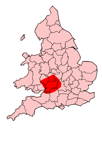
English: A map showing the territory of the Dobunni tribe overlayed in red in the context of the modern county boundaries of England and wales |
| Deiziad | (UTC) |
| Mammenn | |
| Aozer |
|
| Stummoù all | Derivative works of this file: Map of the Territory of the Corieltauvi.svg |
.svg)
.png)
| This is a retouched picture, which means that it has been digitally altered from its original version. Modifications: Now showing Dobunnii territory. The original can be viewed here: Map of the Territory of the Cornovii (Midlands).svg:
|
Evel perc'henn eus ar gwirioù oberour, e embannan an oberenn-mañ dindan an aotreoù-implijout da-heul :
Emañ ar restr-mañ dindan an aotre-implijout Creative Commons Deroadenn-Kenrannañ 3.0 Unported
- Gallout a rit :
- eskemm – eilañ, skignañ ha treuzkas an oberenn-mañ
- kemmañ – azasaat an oberenn-mañ
- diouzh ma heuilhit kement-mañ :
- deroadenn – Rankout a rit reiñ an titouroù perc'henniezh rekis diwar-benn an aozer, pourchas ul liamm war-zu an aotre-implijout ha merkañ hag-eñ ez eus bet graet kemmoù. Gallout a rit en ober en un doare reizh met hep lakaat da grediñ ez oc'h bet aprouet gantañ pe ez eo aprouet gantañ implij an oberenn-mañ.
- eskemmañ rik-ha-rik – Ma tegasit kemmoù, ma treuzfurmit pe ma savit un dra bennak diwar an oberenn-mañ e rankit skignañ an oberenn krouet ganeoc'h dindan an hevelep aotre-implijout pe un aotre-implijout kar-tost d'an hini orin.

|
Aotre zo da eilañ, skignañ ha kemmañ an teul-mañ dindan termennoù ar GNU Free Documentation License, stumm 1.2 pe stummoù nevesoc'h embannet gant ar Free Software Foundation; hep rannoù digemm, na testenn pajenn golo 1 pe golo 4 ebet. Kavet e vo un eilskrid eus an aotre-implijout er rannbennad anvet GNU Free Documentation License. |
Gallout a rit diuzañ an aotre-implijout a fell deoc'h.
Marilh orin ar pellgargadurioù
This image is a derivative work of the following images:
- File:Map_of_the_Territory_of_the_Cornovii_(Midlands).svg licensed with Cc-by-sa-3.0, GFDL
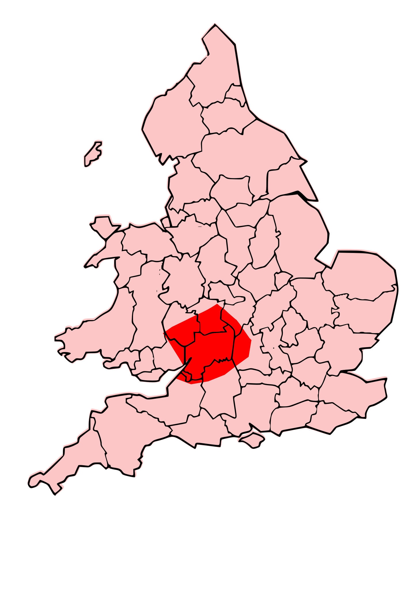
- 2009-09-25T00:09:57Z Jpb1301 744x1052 (153095 Bytes) {{Information |Description={{en|1=A map showing the territory of the Cornovii tribe overlayed in red in the context of the modern county boundaries of England and wales}} |Source=*[[:File:Map_of_the_Territory_of_the_Cornovii_
Uploaded with derivativeFX
Istor ar restr
Klikañ war un deiziad/eur da welet ar restr evel ma oa da neuze.
| Deiziad/Eur | Munud | Mentoù | Implijer | Notenn | |
|---|---|---|---|---|---|
| red | 13 Her 2009 da 19:47 | | 744 × 1 052 (148 Kio) | Jpb1301 | {{Information |Description={{en|1=A map showing the territory of the Dobunni tribe overlayed in red in the context of the modern county boundaries of England and wales}} |Source=*File:Map_of_the_Territory_of_the_Dobunni.svg |Date=2009-10-13 19:46 (U |
| 13 Her 2009 da 17:38 |  | 744 × 1 052 (148 Kio) | Jpb1301 | {{Information |Description={{en|1=A map showing the territory of the Dobunni tribe overlayed in red in the context of the modern county boundaries of England and wales}} |Source=*File:Map_of_the_Territory_of_the_Cornovii_(Midlands).svg |Date=2009-10 |
.svg)
Implij ar restr
Implijout a ra ar bajenn da heul ar restr-mañ :
Implij hollek ar restr
Ober a ra ar wikioù da-heul gant ar restr-mañ :