
Restr:Netherlands during French administration 1810-1814.png

Ment ar rakweled-mañ : 408 × 599 piksel. pizhderioù all : 163 × 240 piksel | 520 × 764 piksel.
Restr orin (520 × 764 piksel, ment ar restr : 889 Kio, seurt MIME : image/png)
![]()
| Tennet eo ar restr-mañ eus Wikimedia Commons ha gallout a ra bezañ implijet evit raktresoù all. Diskouezet eo deskrivadur he fajenn zeskrivañ amañ dindan. |
Diverradur
| Deskrivadur |
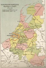
English: Map of Belgium and the Netherlands during the French occupation. Français : Carte de la Belgique et des Pays-Bas pendant l'occupation française. |
||||||||||||||||||||
| Deiziad | before 1910 | ||||||||||||||||||||
| Mammenn | Scan from Atlas de géographie physique, politique et historique à l'usage de l'enseignement primaire et de l'enseignement moyen, Dessain, Liège, 35e éd., s.d., p. 40. | ||||||||||||||||||||
| Aozer |
|
||||||||||||||||||||

Aotre-implijout
|
This work is in the public domain in its country of origin and other countries and areas where the copyright term is the author's life plus 100 years or fewer. This work is in the public domain in the United States because it was published (or registered with the U.S. Copyright Office) before January 1, 1929. | |
| Rummet eo bet ar restr-mañ e-touez ar restroù hep strishadurioù implij anavezet evit ar pezh a sell ouzh ar gwirioù aozer, ha kement-se evit an holl wirioù kar ha stag. | |
Istor ar restr
Klikañ war un deiziad/eur da welet ar restr evel ma oa da neuze.
| Deiziad/Eur | Munud | Mentoù | Implijer | Notenn | |
|---|---|---|---|---|---|
| red | 31 Her 2005 da 11:16 | | 520 × 764 (889 Kio) | BrightRaven | Map of Belgium and the Netherlands during the French occupation. Author : MG Alexis |
Implij ar restr
Implijout a ra an 15 pajenn da heul ar restr-mañ :
Implij hollek ar restr
Ober a ra ar wikioù da-heul gant ar restr-mañ :
- Implij war ar.wikipedia.org
- Implij war ast.wikipedia.org
- Implij war ca.wikipedia.org
- Implij war cs.wikipedia.org
- Implij war en.wikipedia.org
- Implij war eo.wikipedia.org
- Implij war es.wikipedia.org
- Implij war fr.wikipedia.org
- Implij war fy.wikipedia.org
- Implij war gl.wikipedia.org
- Implij war id.wikipedia.org
- Implij war it.wikipedia.org
- Implij war la.wikipedia.org
- Implij war li.wikipedia.org
- Implij war mt.wikipedia.org
- Implij war nl.wikipedia.org
- Implij war vls.wikipedia.org
- Implij war zh.wikipedia.org