
Restr:British isles 802.jpg
Ment ar rakweled-mañ : 572 × 599 piksel. pizhderioù all : 229 × 240 piksel | 458 × 480 piksel | 733 × 768 piksel | 1 076 × 1 127 piksel.
Restr orin (1 076 × 1 127 piksel, ment ar restr : 1,29 Mio, seurt MIME : image/jpeg)
![]()
| Tennet eo ar restr-mañ eus Wikimedia Commons ha gallout a ra bezañ implijet evit raktresoù all. Diskouezet eo deskrivadur he fajenn zeskrivañ amañ dindan. |
Diverradur
| Deskrivadur |
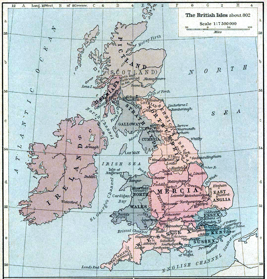
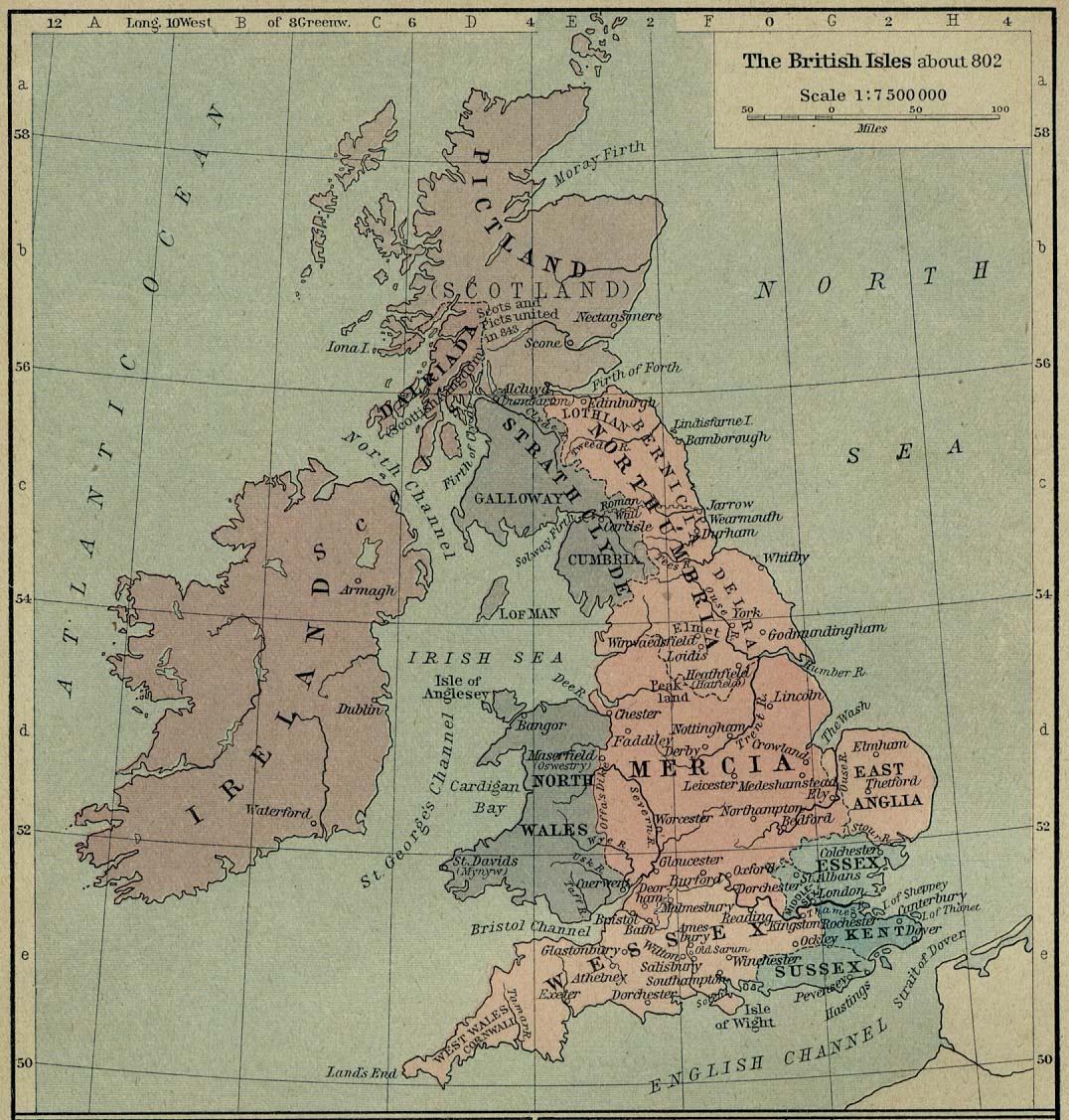
English: Map of the British Isles claiming to represent borders circa 802 AD. |
||||||||||||||||||||||
| Deiziad | |||||||||||||||||||||||
| Mammenn | Shepherd, William R. (1926) Historical Atlas, Category:New York: Henry Holt and Company | ||||||||||||||||||||||
| Aozer |
|
||||||||||||||||||||||
Aotre-implijout
|
The author died in 1934, so this work is in the public domain in its country of origin and other countries and areas where the copyright term is the author's life plus 80 years or fewer. This work is in the public domain in the United States because it was published (or registered with the U.S. Copyright Office) before January 1, 1929. | |
| Rummet eo bet ar restr-mañ e-touez ar restroù hep strishadurioù implij anavezet evit ar pezh a sell ouzh ar gwirioù aozer, ha kement-se evit an holl wirioù kar ha stag. | |
Istor ar restr
Klikañ war un deiziad/eur da welet ar restr evel ma oa da neuze.
| Deiziad/Eur | Munud | Mentoù | Implijer | Notenn | |
|---|---|---|---|---|---|
| red | 12 Eos 2019 da 21:30 | | 1 076 × 1 127 (1,29 Mio) | Alphathon | A few more minor tweaks |
| 12 Eos 2019 da 21:24 |  | 1 076 × 1 127 (1,24 Mio) | Alphathon | re-did cleaning (using original version) | |
| 8 Her 2006 da 18:36 |  | 1 076 × 1 127 (1,19 Mio) | Steinsky | cleaned | |
| 3 Kzu 2005 da 15:47 |  | 1 076 × 1 127 (273 Kio) | Migdejong | Map of the isle Great Brittain in the year 802. Image comes from the University of Texas at Austin: http://geography.about.com/gi/dynamic/offsite.htm?site=http://www.lib.utexas.edu/maps/historical/history%5Feurope.html Map is released into the publi |
Implij ar restr
Implijout a ra an 12 pajenn da heul ar restr-mañ :
Implij hollek ar restr
Ober a ra ar wikioù da-heul gant ar restr-mañ :
- Implij war be-tarask.wikipedia.org
- Implij war be.wikipedia.org
- Implij war de.wikipedia.org
- Implij war el.wikipedia.org
- Implij war en.wikipedia.org
- List of monarchs of East Anglia
- Talk:East Anglia
- List of monarchs of Wessex
- List of monarchs of Northumbria
- List of monarchs of Mercia
- List of monarchs of Kent
- List of monarchs of Sussex
- History of Cornwall
- Constitutional status of Cornwall
- Talk:Regions of England
- Wikipedia:WikiProject Anglo-Saxon Kingdoms
- User:Amitchell125/listofmonarchsofeastanglia
- Template:Anglo-Saxon kings
- Implij war fr.wikipedia.org
- Implij war gd.wikipedia.org
- Implij war got.wikipedia.org
- Implij war he.wikipedia.org
- Implij war hu.wikipedia.org
- Implij war it.wikipedia.org
- Implij war ja.wikipedia.org
- Implij war ka.wikipedia.org
- Implij war lt.wikipedia.org
- Implij war nds.wikipedia.org
- Implij war nl.wikipedia.org
- Implij war pl.wikipedia.org
Gwelet muioc'h eus implij hollek ar restr-mañ.