
Restr:Baro river Gambela.jpg

N'haller ket gwellaat ar pizhder.
Baro_river_Gambela.jpg (500 × 500 piksel, ment ar restr : 61 Kio, seurt MIME : image/jpeg)
![]()
| Tennet eo ar restr-mañ eus Wikimedia Commons ha gallout a ra bezañ implijet evit raktresoù all. Diskouezet eo deskrivadur he fajenn zeskrivañ amañ dindan. |
Diverradur
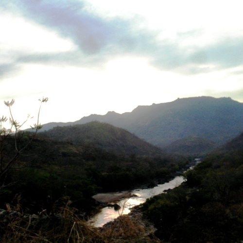
| Deskrivadur |
Baro River in Gambella region, Ethiopia. Original description by uploader: "taking pictures of bridges is strictly forbidden" [][?] Baro River flows to Sudan (cf. this picture). It is also the heart of the Gambella region and Gambella city. People use to go to the river to wash, refresh, chat or just take some time. People belong to many different groups: indigenous Nuer, Anuak, Majangir... or settled Highlanders (for the Abyssinian highlands regardless Amhara, Tigray or Oromo) or Sudanese refugees. The situation of demographic, ethnic and cultural diversity leads to situations of complexity. Inducing tensions, conflicts or violences. At least it is what is written in the books... So far, it looks like a paradise. |
| Deiziad | |
| Mammenn | [1] |
| Aozer | T U R K A I R O |
| Lec’h luc’hskeudennerez | | Gwelet al lec’h-se e : OpenStreetMap |
|---|
Aotre-implijout
Emañ ar restr-mañ dindan an aotre-implijout Creative Commons Deroadenn 2.0 Hollek
- Gallout a rit :
- eskemm – eilañ, skignañ ha treuzkas an oberenn-mañ
- kemmañ – azasaat an oberenn-mañ
- diouzh ma heuilhit kement-mañ :
- deroadenn – Rankout a rit reiñ an titouroù perc'henniezh rekis diwar-benn an aozer, pourchas ul liamm war-zu an aotre-implijout ha merkañ hag-eñ ez eus bet graet kemmoù. Gallout a rit en ober en un doare reizh met hep lakaat da grediñ ez oc'h bet aprouet gantañ pe ez eo aprouet gantañ implij an oberenn-mañ.
| This image was originally posted to Flickr by T U R K A I R O at https://www.flickr.com/photos/7838055@N05/2459587146. It was reviewed on 26 Ebrel 2009 by FlickreviewR and was confirmed to be licensed under the terms of the cc-by-2.0. |
Istor ar restr
Klikañ war un deiziad/eur da welet ar restr evel ma oa da neuze.
| Deiziad/Eur | Munud | Mentoù | Implijer | Notenn | |
|---|---|---|---|---|---|
| red | 26 Ebr 2009 da 12:16 | | 500 × 500 (61 Kio) | Béka~commonswiki | {{Information |Description=Baro River in Gambella region, Ethiopia. Original description by uploader: [http://loc.alize.us/#/flickr:2459587146 "taking pictures of bridges is strictly forbidden"] [][?] [http://bighugelabs.com/flickr/onblack.php?id=245958 |
Implij ar restr
Implijout a ra ar bajenn da heul ar restr-mañ :
Implij hollek ar restr
Ober a ra ar wikioù da-heul gant ar restr-mañ :
- Implij war af.wikipedia.org
- Implij war ar.wikipedia.org
- Implij war arz.wikipedia.org
- Implij war ca.wikipedia.org
- Implij war ceb.wikipedia.org
- Implij war cs.wikipedia.org
- Implij war da.wikipedia.org
- Implij war de.wikipedia.org
- Implij war de.wikivoyage.org
- Implij war el.wikipedia.org
- Implij war en.wikipedia.org
- Implij war en.wikivoyage.org
- Implij war eo.wikipedia.org
- Implij war es.wikipedia.org
- Implij war fa.wikipedia.org
- Implij war fi.wikipedia.org
- Implij war fr.wikipedia.org
- Implij war fr.wikivoyage.org
- Implij war gl.wikipedia.org
- Implij war ha.wikipedia.org
- Implij war he.wikipedia.org
- Implij war hi.wikipedia.org
- Implij war hr.wikipedia.org
- Implij war ig.wikipedia.org
- Implij war it.wikipedia.org
- Implij war it.wikivoyage.org
- Implij war ja.wikipedia.org
- Implij war ka.wikipedia.org
- Implij war ko.wikipedia.org
- Implij war mt.wikipedia.org
- Implij war no.wikipedia.org
Gwelet muioc'h eus implij hollek ar restr-mañ.