
Restr:Aquitani tribes map-fr.svg

Ment rakwel PNG ar restr SVG : 702 × 600 piksel. pizhderioù all : 281 × 240 piksel | 562 × 480 piksel | 899 × 768 piksel | 1 199 × 1 024 piksel | 2 398 × 2 048 piksel | 878 × 750 piksel.
Restr orin (restr SVG file, pizhder 878 × 750 piksel, ment ar restr : 1,26 Mio)
![]()
| Tennet eo ar restr-mañ eus Wikimedia Commons ha gallout a ra bezañ implijet evit raktresoù all. Diskouezet eo deskrivadur he fajenn zeskrivañ amañ dindan. |

Diverradur
| Deskrivadur |
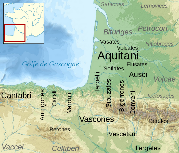
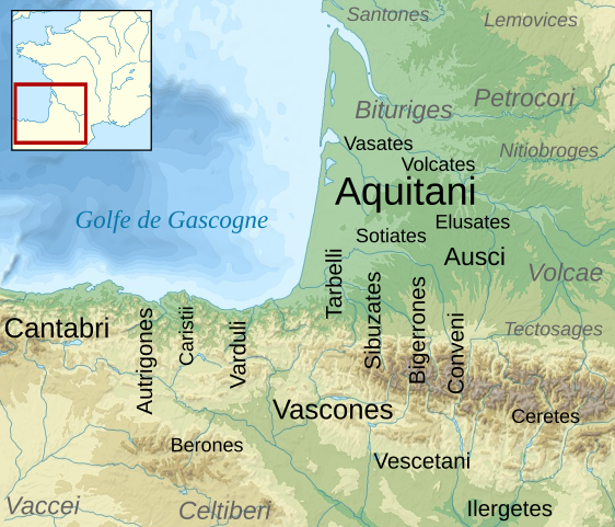
English: Map of the Aquitani and surrounding tribes in early Roman times.
Français : Carte des peuples de la Gaule Aquitaine au début de l'époque romaine.
|
||
| Deiziad | |||
| Mammenn |
|
||
| Aozer | Sémhur | ||
| Stummoù all | |||
| Deroadenn (required by the license) | © Sémhur / Wikimedia Commons / | ||
| SVG | W3C-validity not checked.
|
||
| Graphic Lab |

| Lec’h luc’hskeudennerez | | Gwelet al lec’h-se e : OpenStreetMap |
|---|
Aotre-implijout
Evel perc'henn eus ar gwirioù oberour, e embannan an oberenn-mañ dindan an aotreoù-implijout da-heul :
| Copyleft : Frank eo an oberenn-mañ ; gallout a rit addasparzhañ pe/ha kemmañ anezhi hervez an Aotre-implijout Arz Frank. Kavout a reot ur skouerenn eus an aotre-implijout-mañ e lec'hienn Copyleft Attitude hag e lec'hiennoù all ivez. |
This file is licensed under the Creative Commons Attribution-Share Alike 4.0 International, 3.0 Unported, 2.5 Generic, 2.0 Generic and 1.0 Generic license.
- Gallout a rit :
- eskemm – eilañ, skignañ ha treuzkas an oberenn-mañ
- kemmañ – azasaat an oberenn-mañ
- diouzh ma heuilhit kement-mañ :
- deroadenn – Rankout a rit reiñ an titouroù perc'henniezh rekis diwar-benn an aozer, pourchas ul liamm war-zu an aotre-implijout ha merkañ hag-eñ ez eus bet graet kemmoù. Gallout a rit en ober en un doare reizh met hep lakaat da grediñ ez oc'h bet aprouet gantañ pe ez eo aprouet gantañ implij an oberenn-mañ.
- eskemmañ rik-ha-rik – Ma tegasit kemmoù, ma treuzfurmit pe ma savit un dra bennak diwar an oberenn-mañ e rankit skignañ an oberenn krouet ganeoc'h dindan an hevelep aotre-implijout pe un aotre-implijout kar-tost d'an hini orin.
Gallout a rit diuzañ an aotre-implijout a fell deoc'h.
Marilh orin ar pellgargadurioù
This image is a derivative work of the following images:
- File:France_map_Lambert-93_topographic-blank.svg licensed with Cc-by-sa-3.0,2.5,2.0,1.0, GFDL
- 2008-11-13T17:24:53Z Sting 2000x1898 (1639447 Bytes) + boundary for Channel Islands ; - canals
- 2008-10-01T04:59:44Z Sting 2000x1898 (1682809 Bytes) == Summary == {{Location|46|15|00|N|02|06|00|E|scale:10000000}} {{Information |Description={{en|Blank topographic map of [[:en:France|France]] in the official Lambert-93 projection.}} {{fr|Carte topographique vierge de la [[
- File:Aquitani.gif licensed with PD-self
- 2007-01-25T14:16:29Z Michel BUZE 481x393 (10166 Bytes) {{Information |Description= *Author: [[:en:User:Sugaar|Sugaar]] *Sources: various (ultimately [[:en:Strabo]] and [[:en:Pliny]]) *Based on [[:en::Image:Basque tribes.gif]] (the only diference is that it tags the Aquitani confe
- File:Blank_map_of_Gaul_1st_century_BC.svg licensed with Cc-by-sa-2.5,2.0,1.0, GFDL
- 2007-07-07T19:30:39Z Historicair 755x784 (45078 Bytes) {{Information |Description={{fr}}Carte vierge de la Gaule au Ier siècle avant JC {{en}}Blank map of Gaul 1st century BC. |Source=[[:Image:Caesar's Campaigns in Gaul, 1st century BC.gif]] |Date=07/07/2007 |Author=~~~~ |Permis
Uploaded with derivativeFX
Istor ar restr
Klikañ war un deiziad/eur da welet ar restr evel ma oa da neuze.
| Deiziad/Eur | Munud | Mentoù | Implijer | Notenn | |
|---|---|---|---|---|---|
| red | 17 C'hwe 2009 da 15:46 | | 878 × 750 (1,26 Mio) | Sémhur | {{Information |Description= {{en|Map of the Aquitani and surrounding tribes in early Roman times. * Black: pre-Indoeuropean tribes. * Grey: Celtic tribes. ''Note: the macro-ethnicity of some of the tribes is disputed.''}} {{fr|Carte des peuples de la Ga |
Implij ar restr
Implijout a ra an 2 pajenn da heul ar restr-mañ :
Implij hollek ar restr
Ober a ra ar wikioù da-heul gant ar restr-mañ :
- Implij war an.wikipedia.org
- Implij war azb.wikipedia.org
- Implij war az.wikipedia.org
- Implij war bg.wikipedia.org
- Implij war ca.wikipedia.org
- Implij war de.wikipedia.org
- Implij war el.wikipedia.org
- Implij war en.wikipedia.org
- Implij war en.wiktionary.org
- Implij war eo.wikipedia.org
- Implij war eu.wikipedia.org
- Implij war fi.wikipedia.org
- Implij war fr.wikipedia.org
Gwelet muioc'h eus implij hollek ar restr-mañ.